
Ride to Jiri
The Gateway to Everest • Motorcycle Ride Report
Nepal Moto Tours
Ride Report by Prabhash Thakur
Overview
| Field | Details |
|---|---|
| Ride Dates | Weekend — Saturday & Sunday (suggested: any clear weekend) |
| Duration | 2 days / 1 night |
| Start / End Point | Kathmandu (loop) |
| Total Distance | ~380 km (outbound via Charikot; return via Dhulikhel) |
| Daily Riding Time | 5–6 hours / day |
| Riding Style | Road / Hill Adventure |
| Difficulty | ★★☆☆☆ — Easy to Moderate |
| Overall Rating | ★★★★★ |
Some roads carry more history than others. The route from Kathmandu to Jiri follows the exact path that Edmund Hillary and Tenzing Norgay travelled on their way to Everest in 1953 — a road that was, at the time, a footpath through forest and hill villages. Today it is a paved two-lane road through some of the most beautiful middle-hill country in Nepal, dropping into river valleys and climbing through rhododendron forest to a quiet Sherpa and Jirel town that the rest of the trekking world largely abandoned when Lukla airport opened. Jiri's loss is the motorcycle rider's gain.
The Route
At a Glance
| Day | Segment | Distance | Accommodation |
|---|---|---|---|
| Day 1 | Kathmandu → Bhaktapur → Dhulikhel → Dolalghat → Lamosangu → Charikot → Jiri | ~190 km | Hotel Sherpa / Jiri Lodge, Jiri |
| Day 2 | Jiri → Charikot → Tama Koshi Bridge → Lamosangu → Dolalghat → Dhulikhel → Kathmandu | ~190 km | Kathmandu Suite Homes |
The Jiri loop uses the same road in both directions but offers a fundamentally different experience each way — morning and afternoon light transform the river valleys and the mountain views, and the return direction makes Dhulikhel a proper lunch stop rather than an early transit. Total distance is approximately 380 km over two days of easy-to-moderate riding.
Day 1 — Kathmandu to Jiri (~190 km | 5–6 hrs)
The ride begins on the Araniko Highway, Nepal's eastern artery. Leave Kathmandu before 7am if possible: the road through Bhaktapur and Banepa builds with truck traffic after 8am and the early window is significantly more pleasant. Bhaktapur's brick lanes edge up to the highway and the smell of morning incense drifts across the road — even at speed, this ancient city asserts itself. Banepa is a lively market junction; Sanga above it has a massive white statue of Shiva visible from the road. The ridge climbs steadily.
Dhulikhel at 1,550m is the first proper stop: a ridge-top town with an extraordinary mountain panorama on clear days. The lineup runs from Langtang through Dorje Lakpa, Choba Bamare, Gaurishankar, Numbur and across to the eastern Himalaya — a sweep of white peaks above the terraced hill country below. The old Dhulikhel bazaar is a short detour and worth five minutes of exploration even at a stop-and-go pace. Then the descent begins.
The road drops from Dhulikhel in long, confident curves through terraced farmland to Dolalghat at 634m — the lowest point of the entire route and one of the most visually dramatic. This is where the Indravati and Bhote Koshi rivers join to form the Sun Koshi: a wide, green, muscular river that has earned its name ('River of Gold') honestly. The fish from these confluences is famously good; the dhabas at Dolalghat bridge serve grilled mahaseer and sahar that arriving kayakers and rafters rave about. Stop, order fish with rice, eat with the river in front of you. This is one of the finest simple meal stops near Kathmandu.
From Dolalghat the road runs east along the Sun Koshi, joined briefly by the Bhote Koshi thundering down from Tibet. At Khadichaur — where the Tama Koshi (the Copper River) meets the Sun Koshi from the south — the Araniko Highway continues north toward Tibet and your road turns east. Note the colour of the water at the junction: the Tama Koshi runs visibly different from the Sun Koshi for a stretch downstream of the confluence, the two mixing gradually. This is one of those small river details that the road puts directly in front of you and that stays in the memory.
The climb from Khadichaur to Charikot is approximately 40 km of sustained ascent from ~500m to 1,370m. The tarmac is good and the road is well-engineered — a series of switchbacks and long traverses through increasingly forested terrain, villages appearing at intervals on the hillsides, prayer flags marking the ridgeline temples above. Gaurishankar (7,134m) first appears above the eastern ridgeline approximately 15 km before Charikot and it is a startling sight: a huge double-headed summit completely unexpected in what has been a middle-hill landscape until that moment. It gets more dramatic as you climb.
Charikot is the district headquarters of Dolakha — a proper hill town with a bazaar, fuel stations, several dhabas and the finest roadside Gaurishankar view on the route. This is the natural lunch stop and the place to make decisions about continuing: the 38 km to Jiri from here goes via the Tama Koshi gorge and a long forest climb, and you want to arrive in Jiri with daylight remaining. Fuel up here regardless.
The descent from Charikot to the Tama Koshi bridge is one of the most spectacular sections of road in eastern Nepal: a tight, switchbacking descent into a deep gorge with the copper-green river visible far below and Gaurishankar's summit occasionally framed in the gaps between ridges. The bridge at the bottom is a photographic stop that rewards. Then the road climbs again, entering the pine and rhododendron forest belt that surrounds Jiri. In spring, the rhododendron bloom on this section is extraordinary: dense red and pink above the road and across the valley walls. The final approach to Jiri through the forest on a narrow paved road, with the temperature dropping and the air becoming genuinely alpine, is the finest riding of the day.
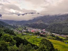
Jiri at 1,905m: a small market town at the end of a long road and the beginning of a legendary walk. The bazaar is compact, the guesthouses are simple and friendly, the evening is quiet in the way that only towns at the end of roads can be. Walk to Hanumante Hill above the bazaar for the last of the daylight and the mountain views. The Gaurishankar–Numbur–Jugal Himal panorama from here, with the valley below and the forest all around, is the payoff for the day's riding.
Day 2 — Jiri to Kathmandu via Charikot and Dhulikhel (~190 km | 5–6 hrs)
Early morning in Jiri rewards the early riser. Walk up to Hanumante Hill before breakfast for the sunrise over Gaurishankar and Numbur — the hills are completely quiet at this hour and the light on the peaks is extraordinary. The Swiss Cheese Factory opens at 9am; buy a wheel of local hard cheese for the road before departing. It is excellent and it travels well.
The return descent to the Tama Koshi is as good going down as up — different light, different views in every corner. Stop at the bridge again: the morning river is different from the afternoon river, the gorge shadows not yet lifted. From Khadichaur the road rejoins the Sun Koshi valley and runs west through Dolalghat and up to Dhulikhel.
Dhulikhel is the lunch stop on the return. The town has several proper terrace restaurants and cafes that cater to day-trippers from Kathmandu — a different universe from the Jiri guesthouses, but well-positioned for a final rest before the capital. The Himalayan panorama from the Dhulikhel ridge on the return is often better than the morning view on Day 1: afternoon light on the peaks in autumn and spring has a particular quality. Sit on a terrace, order something proper, and take your time.
The return through Bhaktapur and into Kathmandu will encounter traffic. Budget an extra 45 minutes beyond the riding time for the city approach. Back in Kathmandu by late afternoon. Tour complete.
The Bike
| Field | Details |
|---|---|
| Motorcycle | Royal Enfield Himalayan 450 |
| Engine | 450cc |
| Loaded Weight | ~195 kg |
| Tyre Setup | Stock |
| Modifications | Luggage rack |
Bike Performance Notes
The Jiri route is a road rider's route. The Himalayan 450 is substantially more machine than the road demands — a 200cc would manage the loop without difficulty. What the Himalayan brings is the comfort of long-distance highway ergonomics on the Araniko section, effortless pull on the sustained Charikot and Jiri climbs, and the assurance of a bike that treats the occasional rough patch with complete indifference. No mechanical issues; the bike performed without any note-worthy event throughout.
One observation: the descent from Charikot to the Tama Koshi bridge involves prolonged braking on tight switchbacks. Monitor brake temperature on loaded descents in hot weather; take the descent patiently rather than quickly. The road rewards controlled descent with extraordinary views, not hurried ones.
Road & Trail Conditions
| Section | Surface | Notes |
|---|---|---|
| Kathmandu → Bhaktapur → Banepa | Paved — busy | The Araniko Highway begins here. Bhaktapur is slow and congested; clear it before 8am. Banepa onwards the road narrows and thins pleasantly |
| Banepa → Dhulikhel | Paved — good | A beautiful ridge road climbing to 1,550m. Himalayan views on clear days; popular photo stop. The Old Dhulikhel loop adds 5 minutes and is worth it |
| Dhulikhel → Dolalghat | Paved — winding descent | The road drops ~900m to the Sun Koshi confluence at Dolalghat (634m). Long sweeping bends, terraced fields, excellent visibility |
| Dolalghat → Lamosangu → Khadichaur | Paved — river road | Fast, flat road along the Sun Koshi then Bhote Koshi / Tama Koshi confluence at Khadichaur. The rivers are spectacular throughout |
| Khadichaur → Charikot | Paved — uphill climb | Turn east at Khadichaur. A sustained, winding climb of ~40 km to Charikot (1,370m). Good tarmac, beautiful hill scenery, Gaurishankar emerging above the ridgeline |
| Charikot → Tama Koshi Bridge → Jiri | Paved / narrow — winding | Descent to the Tama Koshi river, then a steady climb through pine and rhododendron forest to Jiri (1,905m). The final 38 km from the bridge is the finest riding of the route |
The Kathmandu–Jiri route is entirely paved throughout. This is one of the few routes in the Nepal Moto Tours programme with no mandatory off-road sections — the challenge is entirely in the sustained climbing, the winding sections and the occasional blind corner on the forest road above the Tama Koshi. Road maintenance is generally good, though minor pothole sections appear on the Khadichaur–Charikot climb and on the forest road approaching Jiri. Nothing that requires significant caution; standard road awareness is sufficient.
Weather & Conditions
| Factor | Details |
|---|---|
| Best Season | Spring (Mar–May) and Autumn (Sep–Nov). Both seasons deliver clear skies and comfortable riding |
| Spring | Rhododendron bloom between Charikot and Jiri (March–April). Forest sections are vibrant pink and red; mountain views sharp. Recommended window |
| Autumn | Post-monsoon clarity; Gaurishankar exceptionally defined from Charikot. Harvest season adds golden terraced-field colour |
| Summer/Monsoon | Possible but road surfaces can be wet and slippery on the forest climbs. Gaurishankar usually cloud-covered. Not recommended |
| Winter (Dec–Feb) | Cold evenings in Jiri (can drop to 0°C overnight); clear mountain views frequent. Gear up well for the Charikot–Jiri section |
| Altitude | Dhulikhel: 1,550m | Charikot: 1,370m | Jiri: 1,905m | Highest point en route: ~2,000m in the forest above Jiri |
The Jiri route is highly weather-dependent for its best experience: Gaurishankar is the visual centrepiece of the ride and it requires a clear day to reveal itself. Spring mornings (March–May) and autumn days (September–November) are the most reliable windows. The rhododendron bloom between Charikot and Jiri in March and April is a specific seasonal highlight that justifies the timing. Avoid riding this route in the afternoon if you want the mountain view at Charikot — morning clarity is almost always better.
Permits Required
| Item | Details |
|---|---|
| Permits | No permits required for Jiri or Dolakha district. No conservation area or restricted zone entry |
| Entry Fees | No national park or heritage site entry fees on this route |
| Documents | Motorcycle registration papers as standard. No checkpoints or special documentation beyond Lamosangu |
Fuel & Logistics
| Location | Fuel Available | Notes |
|---|---|---|
| Kathmandu | ✅ Yes | Fill up before departing |
| Banepa | ✅ Yes | Top up option on the Araniko Highway |
| Dolalghat | ✅ Yes | Junction town; fuel available |
| Lamosangu | ✅ Yes | Reliable fuel stop before the Khadichaur turn-off |
| Charikot | ✅ Yes | Fill up here before the Jiri climb; fuel available in the bazaar |
| Jiri | ✅ Yes | Basic fuel available in the bazaar. Confirm before arriving in the evening |
Fuel logistics are the simplest of any Nepal Moto Tours route. Petrol is available in every major town on the Araniko Highway and at Charikot and Jiri. The only practical fuel discipline: fill up in Charikot before the Jiri descent, and confirm Jiri availability on arrival in the evening if planning an early departure on Day 2.
Highlights
The Jiri route rewards in a way distinct from Nepal's high-altitude rides: the pleasure is cumulative, layered, and built from river confluences, mountain views, forest roads and the quiet satisfaction of arriving somewhere that most Nepal visitors never reach by road.
| Stop | Why It Matters |
|---|---|
| Bhaktapur (Kathmandu exit) | The Araniko Highway passes through the edge of this UNESCO World Heritage city. A pre-dawn or early morning transit avoids traffic and offers atmospheric brick-lane views |
| Dhulikhel Viewpoint (1,550m) | The ridge above Dhulikhel gives one of the most accessible Himalayan panoramas near Kathmandu: Langtang, Dorje Lakpa, Gaurishankar, Numbur and more. A mandatory early-morning stop on clear days |
| Dolalghat (634m) | The lowest point of the route and one of the most dramatic: the Indravati and Bhote Koshi meet to form the Sun Koshi here, a wide, green confluence at the bottom of a deep valley. The fish from these rivers is famous — stop for tea and grilled fish if time allows |
| Khadichaur junction | The Araniko Highway turns north to Tibet here; your road turns east to Jiri. The Tama Koshi joins the Sun Koshi just above this point, its copper-coloured water meeting the green Sun Koshi in a visible confluence from the bridge |
| Charikot (1,370m) | District headquarters of Dolakha and the finest roadside view of Gaurishankar (7,134m) on the entire route. A proper lunch stop; the bazaar has good dhabas and the mountain appears from the main street on clear days |
| Dolakha Bhimsen Temple | 5 km from Charikot, the ancient Bhimsen Temple is one of the most important Hindu temples in eastern Nepal. The resident deity is believed to bleed when national calamity approaches — a deeply held local belief going back centuries |
| Tama Koshi Bridge (below Charikot) | The descent from Charikot to the Tama Koshi river is spectacular — a deep gorge with the copper-green river below and Gaurishankar disappearing behind the ridgeline above. The bridge is a natural stop and photograph |
| Jiri Bazaar (1,905m) | The original Everest Base Camp trek gateway, unchanged in essential character since Hillary and Tenzing passed through in 1953. A genuine Sherpa and Jirel hill town with a weekly bazaar, Swiss-built agricultural projects and a refreshing calm |
| Jiri Swiss Projects | The Swiss Development Corporation established a cheese factory, yak farm and agricultural development centre in Jiri in the 1970s – 80s. The cheese factory still operates and produces Nepal's best-regarded hard cheese. Buy some |
| Hanumante Hill viewpoint | A short hike above Jiri bazaar gives a panorama of the valley, the surrounding Mahabharat Range and — on clear days — Gaurishankar, Numbur and Jugal Himal. Excellent at dawn on Day 2 before departure |
- The first sight of Gaurishankar above the Dolakha ridgeline — a double-headed 7,134m summit appearing with no warning above what has been hill country for hours. This is the defining visual moment of the route and it arrives entirely unexpectedly
- The Tama Koshi gorge between Charikot and Jiri: deep, copper-green river below, switchbacking descent, rhododendrons overhead in spring. The finest riding section of the route and one of the most beautiful middle-hill roads in Nepal
- Arriving in Jiri in the evening with the valley below and the forest quiet. This town has been the gateway to Everest for 70 years and it carries that history without drama, going about its business with the same calm it always has
- Dolalghat fish stop at the Sun Koshi confluence. Grilled river fish, the river in front of you, and the knowledge that you are at the lowest and the most geologically raw point of a route that started 900m above in Kathmandu
- Dhulikhel viewpoint at dawn or in the clear afternoon: a mountain panorama accessible within 90 minutes of Kathmandu that includes peaks across five separate Himalayan ranges
Lowlights & Challenges
- The Bhaktapur and Banepa traffic on departure can be genuinely frustrating. Leave Kathmandu by 6:30–7:00am to stay ahead of the trucks; the reward is a clear run all the way to Dolalghat
- The road from Khadichaur to Charikot is a sustained climb with multiple blind hairpin bends and occasional gravel on the exit of corners. Not technically difficult but requires sustained concentration — there is no cruise-control section on this road
- Gaurishankar can be cloud-covered by midday in spring; the view from Charikot is better in the morning. If arriving at Charikot after 11am, the mountain may already be obscured. Plan your Day 1 timing accordingly
- Jiri is a small town with limited evening entertainment and basic accommodation. This is a feature, not a fault — but riders expecting a Pokhara Lakeside experience will be disappointed. Expect simple food, early evenings and genuine quiet
- The return from Jiri on Day 2 is the same road in reverse — slightly faster but not dramatically different in character. The route does not offer a meaningfully different return option the way the Nuwakot or Mustang loops do
- Jiri ATMs can be unreliable on weekends. Carry sufficient cash from Charikot
Notable Stops Along the Way
| Stop | Why It Matters |
|---|---|
| Bhaktapur (Kathmandu exit) | The Araniko Highway passes through the edge of this UNESCO World Heritage city. A pre-dawn or early morning transit avoids traffic and offers atmospheric brick-lane views |
| Dhulikhel Viewpoint (1,550m) | The ridge above Dhulikhel gives one of the most accessible Himalayan panoramas near Kathmandu: Langtang, Dorje Lakpa, Gaurishankar, Numbur and more. A mandatory early-morning stop on clear days |
| Dolalghat (634m) | The lowest point of the route and one of the most dramatic: the Indravati and Bhote Koshi meet to form the Sun Koshi here, a wide, green confluence at the bottom of a deep valley. The fish from these rivers is famous — stop for tea and grilled fish if time allows |
| Khadichaur junction | The Araniko Highway turns north to Tibet here; your road turns east to Jiri. The Tama Koshi joins the Sun Koshi just above this point, its copper-coloured water meeting the green Sun Koshi in a visible confluence from the bridge |
| Charikot (1,370m) | District headquarters of Dolakha and the finest roadside view of Gaurishankar (7,134m) on the entire route. A proper lunch stop; the bazaar has good dhabas and the mountain appears from the main street on clear days |
| Dolakha Bhimsen Temple | 5 km from Charikot, the ancient Bhimsen Temple is one of the most important Hindu temples in eastern Nepal. The resident deity is believed to bleed when national calamity approaches — a deeply held local belief going back centuries |
| Tama Koshi Bridge (below Charikot) | The descent from Charikot to the Tama Koshi river is spectacular — a deep gorge with the copper-green river below and Gaurishankar disappearing behind the ridgeline above. The bridge is a natural stop and photograph |
| Jiri Bazaar (1,905m) | The original Everest Base Camp trek gateway, unchanged in essential character since Hillary and Tenzing passed through in 1953. A genuine Sherpa and Jirel hill town with a weekly bazaar, Swiss-built agricultural projects and a refreshing calm |
| Jiri Swiss Projects | The Swiss Development Corporation established a cheese factory, yak farm and agricultural development centre in Jiri in the 1970s – 80s. The cheese factory still operates and produces Nepal's best-regarded hard cheese. Buy some |
| Hanumante Hill viewpoint | A short hike above Jiri bazaar gives a panorama of the valley, the surrounding Mahabharat Range and — on clear days — Gaurishankar, Numbur and Jugal Himal. Excellent at dawn on Day 2 before departure |
Food & Tea Houses
The Jiri route passes through some of the most food-culturally diverse districts in eastern Nepal: Newar towns on the Araniko Highway, Tamang villages in the Bhote Koshi valley, Chhetri and Brahmin hill settlements above Khadichaur, and Sherpa and Jirel communities in Jiri itself. Each has its own culinary character and the road puts them all in front of you.
| Stop | What to Eat / Experience |
|---|---|
| Bhaktapur (early transit) | Juju dhau — the famous Bhaktapur king curd in clay pots — is available from early morning at roadside shops near the old city. A classic Kathmandu Valley exit ritual |
| Dhulikhel tea stop | Roadside canteens on the ridge serve strong milk tea and sel roti (sweet fried bread) in the mornings. The mountain view from these tea shop benches is the best in the eastern valley |
| Dolalghat fish stop | The confluence town is well-known for fresh river fish (mahaseer, sahar). Several small restaurants by the bridge serve fried fish with rice and dal. Order it; it is excellent |
| Charikot dhabas | The best lunch stop on the route. A row of local dhabas along the bazaar main street serve dal bhat tarkari of genuinely high quality. Charikot also has a few Newari-style tea houses serving beaten rice snacks |
| Jiri lodges / guesthouses | Dal bhat is the dominant offering and it is very good here. Hotel Sherpa is known for reliable food. The local millet raksi (grain spirit) is available in the evening and is not to be underestimated |
| Jiri Cheese Factory | Not exactly a food stop but a unique experience: locally produced hard cheese, apple products and yak butter from the Swiss-legacy farm operation. Buy cheese for the road |
| Dhulikhel on return | Dhulikhel has a small collection of good restaurants and cafes catering to day-trippers from Kathmandu. A final proper lunch stop before the city. Try Cafe de Peacock or similar terrace cafe for mountain views with food |
One specific note on Jiri: the Dal Bhat in the guesthouses here is made with locally grown rice, seasonal vegetables from the farm terraces and lentils that have come up the road on the same bus as the trekkers. It is wholesome in the truest sense. Eat it here; it is better than the same dish in Kathmandu by a considerable margin.
Accommodation
| Location | Where We Stayed |
|---|---|
| Jiri (Night 1) | Hotel Sherpa or Jiri Lodge, Jiri Bazaar — both clean, well-regarded, and within walking distance of the bazaar and Hanumante Hill trailhead |
| Kathmandu (return night) | Kathmandu Suite Homes |
Hotel Sherpa in Jiri is consistently recommended by riders and trekkers using the old Everest route — clean rooms, reliable kitchen and a location in the upper bazaar area with good valley views. Jiri Lodge is a slightly smaller alternative with a similarly good reputation. Book ahead on weekends and during the spring/autumn trekking windows; Jiri receives more visitors than its size suggests. Both guesthouses are walking distance from Hanumante Hill and the bazaar market.
Tips for Riders Planning This Route
- Leave Kathmandu by 6:30–7:00am to clear Bhaktapur and Banepa before heavy truck traffic builds. The Araniko Highway's first 30 km is dramatically better before 8am
- Stop at Dhulikhel on the way out for the mountain view — even 10 minutes. The ridge panorama is the best accessible viewpoint on the eastern highway and it sets the tone for a day that ends at Gaurishankar country
- Do not skip Dolalghat fish. The mahaseer from the Sun Koshi confluence is genuinely special. Budget 30 minutes at the bridge
- Fill fuel at Charikot without fail before the Jiri descent. Confirm Jiri availability on arrival if planning an early Day 2 start
- Aim to reach Charikot before 11am for the best Gaurishankar view. The mountain typically clouds by midday in spring
- Take the Charikot–Tama Koshi descent slowly. The views are best when you are not focused entirely on the road. Use the wider bends to look, and keep concentration on the tighter ones
- Book Jiri accommodation ahead for weekend stays. Hotel Sherpa and Jiri Lodge both fill on Friday–Saturday nights in season
- Visit the Swiss Cheese Factory on Day 2 morning before departure. It opens at 9am and the local hard cheese is worth buying — genuinely good, unique to Jiri and something that cannot be found in Kathmandu
- Walk Hanumante Hill on both mornings if you can manage one before dinner on Day 1 and one at dawn on Day 2. The views are meaningfully different at different times and neither is worse than the other
- Respect the Dolakha Bhimsen Temple protocol: remove riding boots, no photography inside the inner sanctum without permission, allow devotees priority in the space
Emergency & Practical Information
| Item | Details |
|---|---|
| Mobile Signal | Good throughout on Araniko Highway and in all towns. NTC and Ncell both reliable in Charikot and Jiri. Some patchy sections in the Tama Koshi gorge |
| ATM | ATMs available at Banepa, Dhulikhel, Charikot and Jiri bazaar. Carry sufficient cash; Jiri ATMs can occasionally be unreliable on weekends |
| Medical | District hospital in Charikot (Dolakha); health post in Jiri. Kathmandu is 5–6 hours from Jiri. Carry a standard first-aid kit and any personal medications |
| Fuel | Fuel available at all major towns. No concerns on this route; see Fuel section for details |
| Road Hazards | The Charikot–Jiri forest section has tight bends, occasional loose gravel on corners and some cliff-edge sections above the Tama Koshi. Blind corners throughout the entire route require sustained attention and correct road positioning |
Final Verdict
Would we recommend this ride? Fully and without qualification.
The Jiri route is Nepal motorcycle tour at its most historically resonant. You are following the only road to Everest that existed before Lukla airport was built — the same route that Hillary and Tenzing used, that every Everest expedition used for the first thirty years of the climbing era. The road is paved now and the journey is two days rather than two weeks, but the landscape is essentially unchanged: the same river valleys, the same forest climbs, the same sudden emergence of Gaurishankar above the Dolakha ridge that would have stopped every expedition party in its tracks.
What the Jiri route offers that Nepal's high-altitude circuits cannot is middle-hill riding at its finest. This is not about altitude or physical endurance — it is about the quality of a road, the character of the towns it passes through, and the particular satisfaction of arriving somewhere genuinely off the tourist trail. Jiri is Nepal undisturbed: a small bazaar town at the end of a good road, with a cheese factory built by the Swiss, a weekly market, a view of Gaurishankar from the tea shop, and the knowledge that this was once the gateway to the highest point on earth.
Ride it on a clear spring morning. Stop at Dolalghat for fish. Arrive in Charikot before Gaurishankar clouds. Descend to the Tama Koshi when the rhododendrons are out. Push through the forest to Jiri as the air cools. Walk Hanumante Hill at sunset. There are better-known Nepal motorcycle routes. There are none with more history under the wheels.
★★★★★
Ride Report by Prabhash Thakur | Nepal Moto Tours