
Overview
| Field | Details |
|---|---|
| Ride Dates | April 4–11, 2025 |
| Duration | 8 days |
| Start / End Point | Kathmandu (full loop) |
| Total Distance | ~1,100 km |
| Daily Riding Time | Approx. 5–7 hours / day |
| Riding Style | Adventure / Off-road |
| Difficulty | ★★★☆☆ — Moderate to Challenging |
| Overall Rating | ★★★★★ |
Lower Mustang and Muktinath in April is one of great motorcycle routes in Nepal. The gorge is at its most lush, the apple trees in Marpha are in full blossom, and the mountain clarity on the upper plateau is extraordinary. No restricted area permit required. Just the open road, the world's deepest gorge, and a sacred 3,800-metre shrine that stops you in your tracks.
The Route
| Day | Date | Segment | Accommodation |
|---|---|---|---|
| Day 1 | Apr 4 | Kathmandu → Pokhara | Hotel City Inn, Pokhara |
| Day 2 | Apr 5 | Pokhara → Tatopani (via Beni, Ghasa) | Local Guesthouse, Tatopani |
| Day 3 | Apr 6 | Tatopani → Kalopani (via Rupse Falls, Lete) | Kalopani Guesthouse |
| Day 4 | Apr 7 | Kalopani → Muktinath (via Jomsom, Kagbeni) | The Face Resort, Muktinath |
| Day 5 | Apr 8 | Exploration Day — Muktinath & Kagbeni | The Face Resort, Muktinath |
| Day 6 | Apr 9 | Muktinath → Tatopani (via Marpha, Jomsom) | Local Guesthouse, Tatopani |
| Day 7 | Apr 10 | Tatopani → Pokhara | Hotel City Inn, Pokhara |
| Day 8 | Apr 11 | Pokhara → Kathmandu | Kathmandu Suite Homes |
Day 1 — Kathmandu to Pokhara (~200 km | ~6 hrs)
Departure from Kathmandu early morning — the Prithvi Highway is at its best before the trucks wake up. The road descends from the valley rim at Nagdhunga and unfolds in a series of long river-valley swoops that track the Trisuli for much of the first half. April hillsides are green and alive; rhododendron forests on the upper slopes are still burning red and pink above Naubise. Stop at Malekhu for a cup of milk tea and watch the rafters pushing off into the Trisuli below. The junction town of Mugling is a classic lunch stop — dal bhat at a Thakali canteen, the way it should be done. The road flattens after Mugling, the Marsyangdi joins from the north, and Pokhara announces itself with the first glimpse of Machapuchare's impossible fish-tail peak. Check in, walk the lakeside, rest. The real riding starts tomorrow.
Day 2 — Pokhara to Tatopani via Beni (~120 km | ~5 hrs)
Leave Lakeside by 7am. The road south-west to Beni is good tarmac following the Modi Khola, and the Annapurna range rides the skyline on your left for most of it. Kusma's dramatic suspension bridge is worth a slow pass. Beni is the last town with reliable fuel — fill the tank completely, without exception. From here the transformation is instant: tarmac ends, the Kali Gandaki takes over, and the Mustang corridor begins.
The 45 km of mountain track from Beni to Tatopani is the hardest riding of the entire route. The road hugs cliff faces above the river, squeezes through rockfall debris, crosses gravel fans and cuts through narrow mud-walled sections where only one vehicle fits. April brings the occasional muddy stretch from overnight showers, but generally this is a good-condition window. By the time Tatopani's hot spring steam appears ahead, the arms are tired and the grin is wide. Check in, then head straight to the springs. The sulphur pools at Tatopani on a cool April evening, with the gorge walls rising above you, are not something you forget.
Day 3 — Tatopani to Kalopani via Rupse Falls, Ghasa, Lete (~65 km | ~5 hrs)
Depart Tatopani early and the morning light is extraordinary — long shadows in the gorge, cool air, and the road climbing steadily. Rupse Waterfall appears around a bend near Ghasa: a powerful single-drop cascade tumbling directly to the road. Stop, stand under it briefly if you want, and continue. The road surface improves slightly through Ghasa and Lete but remains off-road in character — loose rock sections, gravel on blind bends, and the constant presence of the Kali Gandaki to the right. The gorge walls close in spectacularly between Ghasa and Lete — this is the narrowest and most dramatic section of the Kali Gandaki canyon.
Kalopani at 2,530m is a revelation: suddenly the gorge opens, the valley widens, and two of the world's 8,000m peaks appear directly in front of you. Dhaulagiri (8,167m) dead ahead; Nilgiri (7,061m) to the right. The village viewpoint is one of the finest roadside mountain panoramas in Asia. Overnight in Kalopani — allow time to acclimatise before the push to Muktinath tomorrow.
Day 4 — Kalopani to Muktinath via Jomsom & Kagbeni (~85 km | ~5 hrs)
An early start is critical today — the Kali Gandaki afternoon wind is ferocious above Jomsom, and you want to be off the exposed plateau before it arrives. Through Tukuche and into Marpha the landscape transforms: the gorge widens into a broad desert plateau, the trees thin out, and the road becomes a fast gravel track through increasingly arid terrain. Marpha deserves a proper stop: wander the flagstone alleys, step into the Samteling Monastery at the top of the village, and eat something — the apple pie here is genuinely exceptional. The apple trees are in full blossom in April, white flowers against pale blue sky and brown rock. One of those scenes.
Jomsom is 7 km north: the district capital of Mustang, with a tiny airstrip, ATMs, fuel, cafes, a police post and the Jomsom viewpoint tower. Fuel up and draw cash — these are your last chances before Muktinath. Then ride north 12 km to Kagbeni. The town emerges at a river confluence like something from a different era entirely: ochre-walled monastery perched on a bluff, dark medieval alleys, prayer wheels and yaks. Allow thirty minutes to walk the village before climbing to Muktinath.
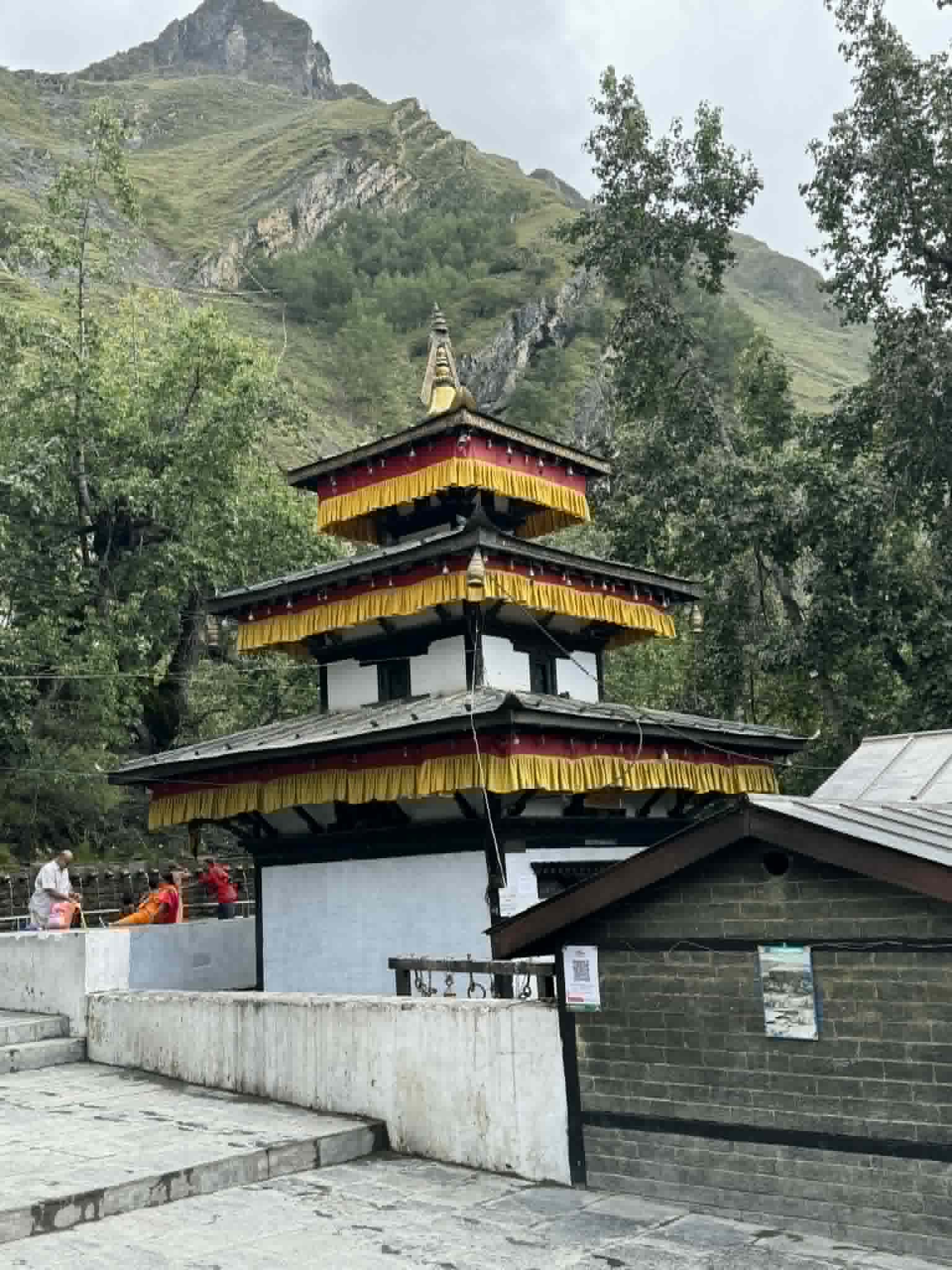
The 22 km from Kagbeni to Muktinath is the most striking stretch of the entire tour — the road zigzags steeply up the western face of the valley through a landscape that is pure Himalayan high desert. By the time the Ranipauwa plateau appears and the temple complex comes into view, you are at 3,800m and every breath feels earned. Visit the temple before sunset if possible.
Day 5 — Exploration Day: Muktinath & Kagbeni
A full, unhurried day at altitude. Muktinath Temple rewards slow attention: the 108 stone water spouts of Mukti Dhara emerge from the cliff face and cascade into the courtyard — Hindus believe bathing under all 108 brings liberation, and even if you do not complete the full circuit, standing among pilgrims filling vessels, monks lighting butter lamps at the adjacent Buddhist gompa, and the total silence of the high plateau beyond — it is one of the more quietly powerful experiences Nepal offers. The eternal flame of Jwala Mai burns from a natural underground gas vent, remarkable for its altitude and what it means to the thousands who come here.
Afternoon: ride or walk back to Kagbeni for a deeper exploration of its medieval quarter. The Red Monastery (Kag Chode Thupten Samphel Ling Gompa) holds religious festivals and art worth seeing. The Kali Gandaki riverbed running north into Upper Mustang territory is visible from the edge of town — a provocative horizon for those who have already done Upper Mustang motorbike tour, or a preview for those yet to go. Return to Muktinath for the night.
Day 6 — Muktinath to Tatopani via Marpha & Jomsom (~107 km | ~5-6 hrs)
The descent is a different ride entirely — different light, different vantage points, different air. The Muktinath plateau in the early morning is breathtakingly still before the wind arrives. Drop back through Kagbeni quickly and stop again in Marpha — this time for the brandy. The local distillery has been producing apple-based spirits since the 1960s horticultural farm was established, and a small bottle makes for an excellent souvenir that fits in a jacket pocket. The descent south from Marpha through Tukuche, Kobang and Lete offers different views of Dhaulagiri's south face and the upper gorge before it tightens again past Ghasa. Reach Tatopani by late afternoon for a final soak in the hot springs.
Day 7 — Tatopani to Pokhara (~120 km | ~5 hrs)
The return through the gorge is faster going south — familiar territory, lighter load. The road from Beni back to Pokhara is a relief: good tarmac, easy bends, the Annapurnas appearing then disappearing as the road curves through the lower hills. Pokhara by early afternoon. Walk Lakeside, eat well, sleep in a proper bed. It has been earned.
Day 8 — Pokhara to Kathmandu (~200 km | ~6 hrs)
The return leg on the Prithvi Highway has a different rhythm — you are watching the hills instead of looking ahead, reflecting on the gorge and the altitude and the temple. Stop at Mugling again for dal bhat. Back into Kathmandu traffic by evening. Tour complete.
The Bike
| Field | Details |
|---|---|
| Motorcycle | Royal Enfield Himalayan 450 |
| Engine | 450cc |
| Loaded Weight | ~200 kg |
| Tyre Setup | Stock |
| Modifications | Luggage rack, bash plate |
Bike Performance Notes
The Royal Enfield Himalayan 450 handled everything this route threw at it without complaint. The Beni-to-Tatopani section is arguably the hardest riding of the Lower Mustang route — sustained vibration, loose rock, narrow shelf roads and the occasional blind bend — and the Himalayan absorbed it with the confidence that has made this machine the default choice for serious Nepal adventure riding. The extra fitment of a bash plate on this trip proved its worth once on a deep rocky section south of Ghasa. No mechanical failures; the bike ran cleanly to altitude and back. The Himalayan 450 is the right machine for this route.
Road & Trail Conditions
| Section | Surface | Notes |
|---|---|---|
| Kathmandu → Pokhara (Prithvi Hwy) | Paved — good | Fast, busy highway; stick to the left. Trisuli River views from Naubise onwards |
| Pokhara → Beni | Mostly paved | Smooth start; enjoy it while it lasts |
| Beni → Tatopani | Gravel / rocky track | Rough begins at Beni. Narrow cliff-hugging sections. Muddy after rain. 45–50 km of genuine off-road |
| Tatopani → Kalopani | Mixed: rock, gravel, mud | Waterfalls visible from road; sections of deep gravel in Kali Gandaki riverbed |
| Kalopani → Jomsom | Gravel / riverbed | Wide open but dusty; stunning views of Dhaulagiri and Nilgiri on the right |
| Jomsom → Kagbeni | Gravel | 12 km, fast and easy; headwind likely in the afternoon |
| Kagbeni → Muktinath | Paved / compact gravel | Final 22 km is largely paved and well-maintained. The road zigzags steeply up to 3,800m |
April is generally a favourable window for this route. The pre-monsoon period brings occasional overnight showers that can leave mud on the lower gorge track, but conditions dry quickly by mid-morning. The Beni to Tatopani section remains the most demanding section regardless of season — plan time, not distance, for this stretch. Above Jomsom, the road to Muktinath is the best-maintained section of the entire route and the easiest riding.
Weather & Conditions
| Factor | Details |
|---|---|
| Season Ridden | Spring (April) |
| Pokhara / Beni | Warm and green; 22–30°C. April brings rhododendron bloom on the hillsides |
| Muktinath at Altitude | Cool to cold; daytime 5–12°C, night can drop below 0°C — pack layers |
| Wind | Famous afternoon gales in the Kali Gandaki gorge; start every riding day before 8am |
| Dust | April is drier; dust picks up significantly above Jomsom |
| Visibility | Excellent spring clarity; Annapurna, Dhaulagiri, Nilgiri all in sharp focus |
| Best Time to Ride | March–May and October–November |
April is one of the two ideal months for this tour. The spring window (March–May) delivers clear mountain visibility, moderate temperatures in the lower valley and bearable cold at altitude. The Mustang plateau is emerging from its winter stillness: apple trees in blossom, the first trekkers on the trail, and the enormous peaks in their sharpest pre-monsoon definition. The afternoon wind in the Kali Gandaki gorge is the one constant hazard — without exception, start every day early.
Permits Required
Lower Mustang — including Jomsom, Kagbeni and Muktinath — does NOT require the Upper Mustang Restricted Area Permit (RAP). The two standard conservation and trekking permits below cover the entire route.
| Permit | Cost (approx.) | Where to Obtain |
|---|---|---|
| ACAP (Annapurna Conservation Area Permit) | NPR 3,000 | TIMS Counter, Pokhara or Kathmandu |
| TIMS Card | NPR 2,000 | TIMS Counter, Pokhara or Kathmandu |
- Carry original permit documents at all checkpoints: Beni, Tatopani, Jomsom and Kagbeni all operate active permit checks
- Motorcycle registration papers must be carried at all times
- Arrange permits in Pokhara (TIMS/ACAP office, Lakeside) the morning before departure on Day 2 — it takes under an hour
Fuel & Logistics
| Location | Fuel Available | Notes |
|---|---|---|
| Pokhara | ✅ Yes | Fill tank completely before departing |
| Beni | ✅ Yes | Last guaranteed fuel before the mountains — top up here without fail |
| Tatopani | ⚠️ Limited | Occasionally available; do not rely on it |
| Jomsom | ✅ Yes | Fill up fully — last source before Muktinath |
| Muktinath | ❌ No | None available; plan fuel from Jomsom |
Carry a minimum of 2–3 litres of spare fuel in a small metal can beyond Jomsom. A 450cc Himalayan consumes approximately 3–3.5L/100km in off-road conditions; from Jomsom to Muktinath and back is roughly 44 km return, well within comfortable range from a full tank. Carry more if you plan any extended riding on Day 5.
Highlights
This route rewards in layers. The gorge hits you with raw geology and physical riding. The villages offer culture and warmth. The altitude delivers silence and perspective. Standout moments from this trip:
| Stop | Why It Matters |
|---|---|
| Manakamana Temple (en route Day 1) | Accessible by cable car near Mugling; an optional but atmospheric detour on the highway leg |
| Tatopani Hot Springs | Natural sulphur springs on the Kali Gandaki bank. After a long day of off-road, this is genuinely restorative |
| Rupse Waterfall (near Ghasa) | Thundering cascade visible from the road. A photogenic stop that signals you are entering the gorge proper |
| Kalopani Viewpoint | One of the finest roadside mountain panoramas in Nepal — Dhaulagiri, Tukuche and Nilgiri filling the frame |
| Marpha Village | Apple capital of Nepal. White-walled stone alleys, ancient monastery, apple pie, cider and the local brandy — a mandatory lunch stop |
| Jomsom | District HQ, last ATM, last fuel, and viewpoint tower over the Kali Gandaki valley. Stock everything here |
| Kagbeni | Medieval walled village; narrow flagstone alleys, ancient chortens, an imposing ochre monastery and the gateway to Upper Mustang |
| Muktinath Temple | Sacred to Hindus and Buddhists; 108 holy water spouts (Mukti Dhara), eternal natural gas flame (Jwala Mai), and towering Himalayan backdrop |
| Dhumba Lake (Jomsom) | Glacial lake 2 km from Jomsom; best visited in the late afternoon when the Nilgiri reflection is at its most vivid |
- Arriving at Muktinath at dusk on Day 4 — the white temple complex glowing against the darkening plateau, prayer flags snapping, and the peaks above completely still. This is why you came
- The morning light in the Kali Gandaki gorge between Tatopani and Ghasa — shafts of sun hitting the cliff faces while the road is still in shadow. Riding into it feels cinematic
- Marpha in April blossom — the apple trees line the approach road and the village lanes smell of flowers. It is one of the most photogenic villages in Nepal and it is completely genuine
- Standing at the Kalopani viewpoint with Dhaulagiri directly in front of you at 8,167m. No zoom required
- The hot spring at Tatopani after Day 2's tough gorge riding. The combination of exhausted arms, sulphur water and gorge-wall starscape is one of Nepal's great simple pleasures
Lowlights & Challenges
- The Beni to Tatopani section is relentless. Forty-five kilometres of cliff track, deep gravel and narrow switchbacks take significantly longer than the distance suggests. Do not underestimate it
- The Kali Gandaki afternoon wind is not a guidebook exaggeration — it is a genuine force. We saw a jeep pushed sideways on the exposed stretch north of Jomsom at 2pm. Start early, every day
- Altitude at Muktinath (3,800m) is real. We had one rider with a mild headache on Day 4. Diamox, hydration and the Kalopani overnight acclimatisation stop both helped. Do not ride straight from Jomsom to Muktinath without the intermediate stop
- Dust above Jomsom is significant in April — a buff/gaiter and sealed goggles are non-negotiable
- Food choices narrow significantly above Tatopani. Embrace dal bhat, thukpa and tea. The altitude and effort make everything taste better than it has any right to
- The return ride from Tatopani through the gorge is still rough in both directions. The gorge does not get easier — it just becomes familiar
Notable Stops Along the Way
| Stop | Why It Matters |
|---|---|
| Manakamana Temple (en route Day 1) | Accessible by cable car near Mugling; an optional but atmospheric detour on the highway leg |
| Tatopani Hot Springs | Natural sulphur springs on the Kali Gandaki bank. After a long day of off-road, this is genuinely restorative |
| Rupse Waterfall (near Ghasa) | Thundering cascade visible from the road. A photogenic stop that signals you are entering the gorge proper |
| Kalopani Viewpoint | One of the finest roadside mountain panoramas in Nepal — Dhaulagiri, Tukuche and Nilgiri filling the frame |
| Marpha Village | Apple capital of Nepal. White-walled stone alleys, ancient monastery, apple pie, cider and the local brandy — a mandatory lunch stop |
| Jomsom | District HQ, last ATM, last fuel, and viewpoint tower over the Kali Gandaki valley. Stock everything here |
| Kagbeni | Medieval walled village; narrow flagstone alleys, ancient chortens, an imposing ochre monastery and the gateway to Upper Mustang |
| Muktinath Temple | Sacred to Hindus and Buddhists; 108 holy water spouts (Mukti Dhara), eternal natural gas flame (Jwala Mai), and towering Himalayan backdrop |
| Dhumba Lake (Jomsom) | Glacial lake 2 km from Jomsom; best visited in the late afternoon when the Nilgiri reflection is at its most vivid |
Food & Tea Houses
The Mustang corridor tea houses are among the warmest and most authentic in Nepal. Run primarily by Thakali families whose culture and cuisine developed along the ancient salt trade route, the mountain lodges here have been feeding travellers for centuries. April brings a pleasant mix of spring trekkers and pilgrims, meaning the tea houses are staffed and stocked without the peak-season crowds of October.
| Location | What to Eat / Experience |
|---|---|
| Mugling (highway stop) | Dal bhat and mustard greens at a roadside Thakali canteen — a classic highway ritual |
| Tatopani guesthouses | Trekker-oriented menus: dal bhat, thukpa (Tibetan noodle soup), momos, and eggs. Sit on the terrace with gorge views |
| Kalopani tea houses | Simple but excellent vantage point hotels; order the lentil soup and warm up before the altitude push |
| Marpha bakeries & lodges | Famous apple pie, apple crumble, fresh cider, apple brandy and locally-made dried fruit. Do not skip this |
| Jomsom cafes | Surprisingly good espresso and proper meals. The best-provisioned stop before Muktinath |
| Muktinath guesthouses | Basic but comfortable high-altitude fare: hot vegetable soup, tsampa porridge, butter tea, rice and dal |
| Kagbeni tea houses | Tibetan-influenced menus; try yak cheese omelette and the local butter tea if you are feeling adventurous |
One specific recommendation: the Annapurna tea house at the bottom of the Muktinath ascent in Ranipauwa village, run by an elderly Thakali woman, serves the best butter tea and lentil soup on the route. No sign. Red door. Worth the brief search.
General rule for the entire route: eat where the locals eat. Order dal bhat everywhere that offers it. Never skip Marpha.
Accommodation
| Location | Where We Stayed |
|---|---|
| Pokhara (Day 1 & Day 7) | Hotel City Inn, Pokhara |
| Tatopani (Day 2 & Day 6) | Local Guesthouse, Tatopani |
| Kalopani (Day 3) | Kalopani Guesthouse |
| Muktinath (Days 4 & 5) | The Face Resort, Muktinath |
| Kathmandu (final night) | Kathmandu Suite Homes |
The Face Resort at Muktinath is comfortably the best accommodation on the upper section — heated rooms, attached bathrooms, a good kitchen and a terrace with direct Himalayan views. Book ahead in April if possible; the resort fills with both trekkers and pilgrimage groups. Tatopani guesthouses are simple but comfortable; specify a room above ground floor for slightly more warmth and better views. Hotel City Inn in Pokhara and Kathmandu Suite Homes are consistent, reliable and well-placed.
Tips for Riders Planning This Route
- Start every riding day by 7–8am. The Kali Gandaki gorge afternoon wind is the single biggest operational constraint on this route and the one most riders regret ignoring
- Buy ACAP and TIMS permits in Pokhara the morning of Day 2 before departing. The office opens at 9am; you can be on the road by 9:30am
- Fit a bash plate before departure. The Beni–Ghasa section will find any unprotected sump
- Carry cash from Pokhara or the Jomsom ATM. Nothing is card-accessible above Jomsom and very little in Tatopani
- Download OsmAnd or Maps.me offline maps for the Mustang valley before leaving Pokhara. Signal above Jomsom is unreliable
- Spend the night at Kalopani (Day 3) rather than pushing straight to Jomsom. The acclimatisation rest makes the Muktinath ascent dramatically more comfortable
- April dust above Jomsom requires a proper seal around the eyes and nose. Standard open-face helmets + dust buff + riding goggles. Dust infiltrates everything in the off-road sections
- Carry a basic repair kit: tyre plugs, mini compressor, cable ties, duct tape, spare levers. Basic tools are far away above Tatopani
- Respect the ritual space at Muktinath: remove boots before entering the temple courtyard, speak quietly, and ask permission before photographing pilgrims
- A reusable warm water bottle is extremely useful at altitude. Fill from boiled water at guesthouses every morning
Emergency & Practical Information
| Item | Details |
|---|---|
| Mobile Signal | Good on Prithvi Highway and Pokhara; NTC / Ncell available in Jomsom. Patchy to absent above Jomsom and at Muktinath |
| ATM | Pokhara (main Lakeside ATMs) and Jomsom. Carry sufficient cash for Days 4–6 in full |
| Medical | Basic health post in Jomsom; nearest hospital is Pokhara. Carry a first-aid kit and diamox for altitude |
| Altitude | Kalopani: ~2,530m | Jomsom: ~2,720m | Kagbeni: ~2,800m | Muktinath: ~3,800m |
| Rescue | Helicopter evacuation possible from Jomsom airstrip in emergency; get adequate travel insurance |
Final Verdict
Would we recommend this ride? Without a single hesitation.
The Muktinath & Lower Mustang motorcycle adventure in April is arguably the finest accessible adventure motorcycle route in Nepal — and one of the finest in Asia. It requires no special permit, demands genuine off-road competence, and returns experiences so varied and vivid that the eight days feel simultaneously too short and completely sufficient.
You leave Kathmandu on a busy highway and arrive, four days later, at a 3,800-metre sacred temple where Hindu priests and Buddhist nuns manage the same shrine, where water springs from 108 stone spouts and a flame burns from the ground with no visible source, and where the Annapurna Himalaya fills the horizon from edge to edge. The road there is tough. The gorge is relentless. The dust is real. And none of it matters once you are standing in that courtyard at dawn.
April adds something extra: blossom on the Marpha apple trees, rhododendrons on the lower hillsides, spring light on the peaks, and a warmth in the valley that does not yet exist in March. This is a ride that changes you slightly — in the way that all the best rides do.
★★★★★
Ride Report by Prabhash Thakur | Nepal Moto Tours | Published April 2025
Tags: Lower Mustang • Muktinath • Kali Gandaki • Kagbeni • Marpha • Nepal Motorcycle Tour • Adventure Riding