
Every rider heading to Upper Mustang has heard about Lo Manthang. The ancient walled city. The ochre cliffs. The sky caves. The feeling of riding somewhere genuinely untouched.
What they haven't heard — at least not in useful detail — is what happens in the kilometres between Kagbeni and getting there.
The Kagbeni to Upper Mustang section is where the trip either clicks or cracks. It is where foreign riders discover, sometimes uncomfortably, that what they were doing before Kagbeni and what they're doing after are two different activities that happen to involve the same motorcycle.
This guide is written for foreign riders who want to know what actually happens — not a promotional summary, but a stage-by-stage account of how the terrain, the psychology, and the riding demands evolve from the moment you pass the restricted zone checkpoint heading north.
Why Kagbeni Is Not Just a Village
Most route descriptions mention Kagbeni as a waypoint — a fuel stop, a permit check, a photo opportunity. That framing undersells what it actually is.
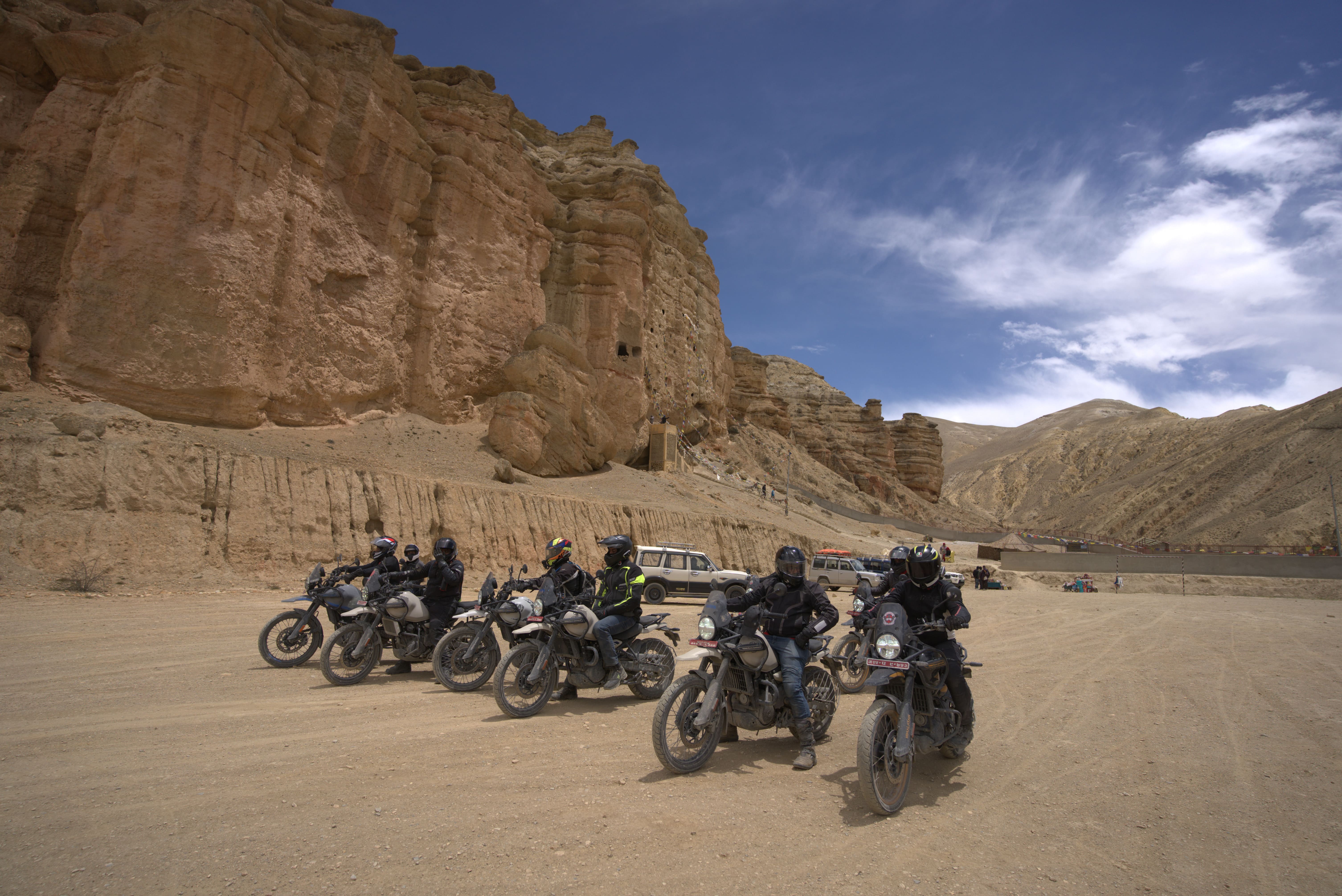
Kagbeni is a system boundary. On either side of its checkpoint, you are in genuinely different environments.
South of Kagbeni, you are riding a shared Himalayan adventure route. Trekkers, jeeps, local traffic, and tourism infrastructure all coexist. There are backup options — mechanics in Jomsom, lodges with reliable food, mobile signal, roads that have seen enough traffic to be somewhat predictable.
North of Kagbeni, the Restricted Area Permit zone begins. Traffic effectively disappears. Settlements become sparse. There is no backup comfort system in the conventional sense. Your guide, your preparation, and your riding judgment are the only resources you have consistent access to.
The permit checkpoint itself is straightforward when your documentation is properly arranged. Your guide presents the Restricted Area Permit, rider details are cross-checked, entry is logged. The process takes 15–30 minutes for a compliant group. The formality is low. The finality is high.
Once you're through, the ride changes character immediately and doesn't change back.
The First Five Kilometres: When It Hits You
There's a specific phenomenon that foreign riders consistently describe in the first kilometres after the Kagbeni checkpoint, and it's worth naming directly: the landscape doesn't just look different, it feels structurally different.
The noise of Himalayan tourism — the shared road energy of other riders, trekking groups, honking jeeps — disappears. Sometimes within minutes of the checkpoint, you can ride for 20 minutes without seeing another vehicle.
The valley opens. The terrain becomes drier and wider. Dust becomes finer and more persistent. The visual scale changes in a way that's difficult to describe until you're in it: distances that look short take longer than expected, and reference points that help you judge speed and progress on normal roads are simply absent.
Riders who have done Lower Mustang before often report that this transition still surprises them. Upper Mustang is not an extension of Lower Mustang — it is a different environment entirely. Lower Mustang prepares you for Himalayan riding conditions. It does not prepare you for the isolation, terrain variability, and mental adjustment that begin immediately after Kagbeni.
The first five kilometres are your recalibration window. Most experienced guides will tell you: if you're going to adjust your riding mindset, do it here, before the terrain demands it from you rather than invites it.
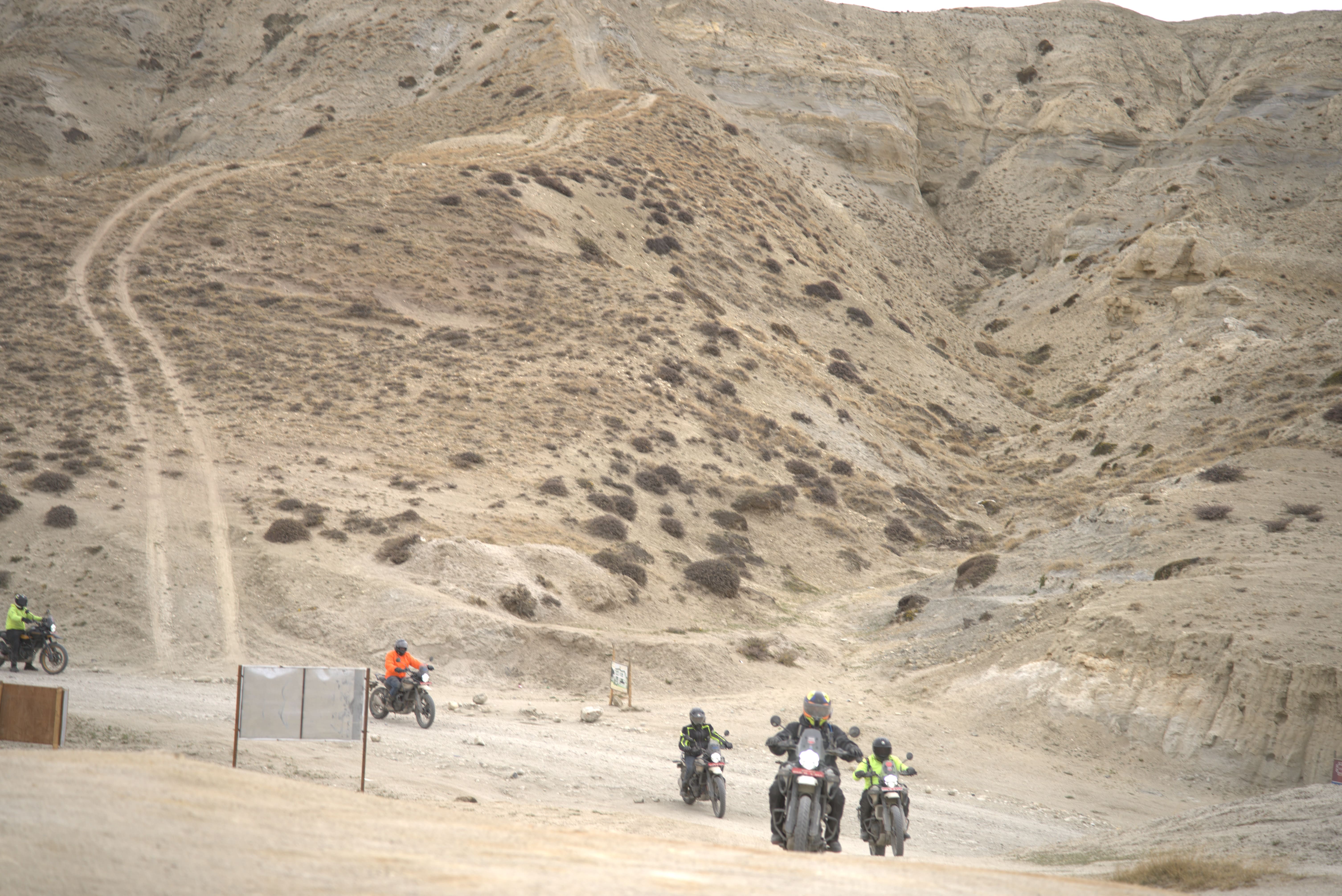
Road Conditions: What "No Road" Actually Means
From Kagbeni northward, the surface stops behaving like a road and starts behaving like a terrain corridor — a designated direction of travel across whatever the landscape provides.
What you will encounter, often within the same kilometre:
- Loose gravel layered over sand, where your front wheel feels light and the rear tracks unpredictably
- Dry riverbeds with irregular rock distribution that requires constant micro-adjustments
- Hard-packed dirt sections that offer deceptive stability before transitioning abruptly
- Washed-out segments where the original track has been redistributed by rain or jeep pressure
- Wind-scoured plateaus where the visual boundary between track and surrounding terrain is genuinely unclear
The critical insight that experienced riders learn quickly: there is no consistent traction profile. The surface that worked for the last ten minutes gives no guarantee about the next ten. Riding on continuous expectation of what the surface will do — rather than reading what it is doing — is the most common technical mistake on this section.
For riders coming from predominantly tarmac or managed gravel backgrounds, this demands a specific adjustment: shorter focus distance, lighter grip, and a willingness to reduce speed well before a problem appears rather than reacting after it does.
Jeep Traffic: The Hidden Priority System
Upper Mustang feels remote. It is also a functioning logistics corridor for local supply and tourism transport toward Lo Manthang.
You will share the track with local jeeps, supply vehicles, and tourism 4WDs — and the dynamic is different from what most foreign riders expect.
Jeeps in this corridor are operated by drivers who know every metre of the track. They move with confidence and at speeds that can seem aggressive given the surface conditions. They do not always slow down early for approaching motorbikes on narrow sections.
The practical rule: you are not the primary user of this route. Jeeps carry supplies to villages that have limited access windows. Your expedition timeline is leisure. Theirs is logistics. The right approach is to treat every narrow section as a potential jeep encounter and position accordingly — hugging the inside line, reducing speed, and giving width.
Riders who approach narrow cliffside sections assuming priority will have unpleasant corrections. Riders who treat the jeep traffic as the dominant system adapt quickly and have fewer problems.
Stage by Stage: How the Route Actually Progresses
Kagbeni to Chhusang — The First True Isolation Zone
This early section is where riders most commonly underestimate what's coming. The terrain is valley-based and relatively navigable, which can create a false sense that Upper Mustang is more forgiving than described.
What actually happens: the dryness intensifies, the vegetation disappears, and river crossings appear depending on the season. More importantly, this is where the resource-aware mindset needs to kick in.
Before Kagbeni, you ride thinking about timing and distance. After Kagbeni, and particularly through this first section, experienced riders start thinking about fuel levels, energy, hydration, and weather — because the next town with anything resembling support is not just around the corner, and the afternoon wind is already building somewhere ahead.
Fuel note: carry more than you think you need after Jomsom. Availability beyond Kagbeni is limited to specific stops and not guaranteed. A fuel miscalculation here is a serious problem, not a minor inconvenience.
Chhusang to Samar — The Vertical Transition
The terrain rises and narrows through this section. Switchback climbs begin on loose surfaces. Valley walls close in. Drop-offs appear on exposed sections without barriers.
This is where riding style must formally shift. Standing on the pegs becomes necessary — not occasionally, but as the default position for rough terrain. Riders who haven't practiced extended standing before this trip start feeling it in their lower back and hip flexors. If you haven't conditioned those muscle groups in preparation, this is where you'll be reminded.
The climbs in this section are also where altitude becomes a noticeable factor for the first time. You're approaching and exceeding 3,500m. Engine power is measurably reduced. Riders who push hard on climbs — instead of reading the throttle relative to available power — labour their engines unnecessarily. Let the bike work at its altitude-adjusted pace, not the pace it would do this climb at sea level.
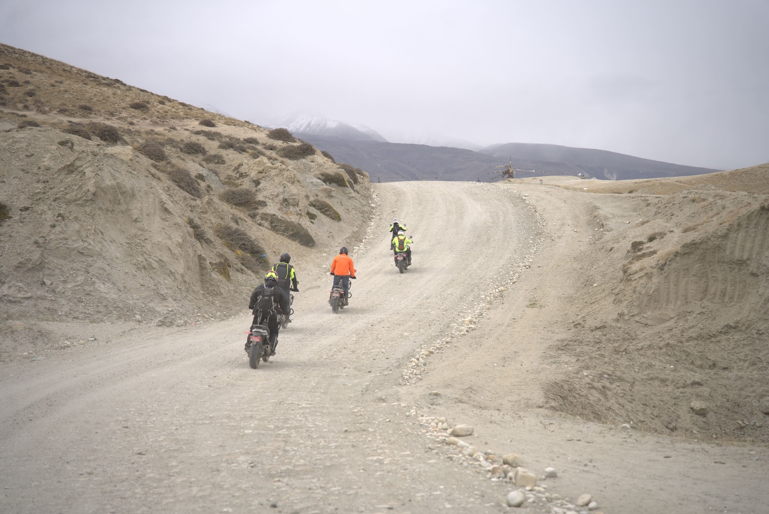
Samar to Ghami — Open Desert Begins
After Samar, the visual identity of Upper Mustang asserts itself fully. Layered rock formations in red, ochre, and grey tones. Deep canyon systems. A landscape that looks geologically ancient because it is.
This visual transformation affects riding in a specific and somewhat counterintuitive way: open terrain creates speed illusion. Without close reference points — buildings, tree lines, roadside markers — riders frequently misjudge both their actual speed and the distance to obstacles ahead. Speeds that feel moderate are higher than perceived. Obstacles that look distant arrive sooner than expected.
The corrective habit: use your speedometer more than your instincts through open plateau sections, and extend your hazard-recognition distance further than you would in enclosed terrain.
Wind builds significantly through this section. It is not constant — it operates in corridor patterns, building through open valleys and easing in sheltered sections. This makes it difficult to judge in advance. The practical rule that experienced guides enforce: ride mornings. Most Upper Mustang wind builds from noon onwards. Riders who push through afternoon plateau sections against full crosswind consistently report it as the most physically draining part of the entire journey — more than any technical climb.
For more on seasonal wind patterns and how they affect the full Upper Mustang route, Nepal Moto Tours' When to Visit guide covers the timing considerations across all their Nepal expeditions in practical detail.
Ghami to Tsarang — Deep Upper Mustang Identity
At Ghami, the remoteness becomes absolute in a way that is distinct from simply being far from a city. Vehicle frequency drops to near zero for long stretches. Settlements are sparse. Long empty riding sections — sometimes 30–40 minutes without visual evidence of another person — become the norm.
Experienced riders describe a specific cognitive effect at this stage: time perception becomes unreliable. Without the normal reference points of traffic, buildings, and human activity, the mental anchors that usually signal progress disappear. Riders can feel simultaneously like they've been riding forever and like they've barely moved.
This is also where cognitive fatigue accumulates differently from physical fatigue. Your body may be managing fine. Your brain — which has been doing continuous surface reading, wind management, altitude compensation, and navigation for hours — is working at a sustained high level with no meaningful rest. Small errors begin appearing: late reactions to surface changes, minor line-choice mistakes, brief lapses in speed judgement.
This is not failure. It is the expected human response to sustained high-demand riding in an austere environment. It is also why experienced riders take deliberate short breaks — 5–10 minutes every 90 minutes or so — not because the legs need it, but because the mind does.
Tsarang to Lo Manthang — The Final Plateau Approach
The last section into Lo Manthang combines peak altitude fatigue with genuinely beautiful riding conditions on the final plateau approach. At around 3,800–4,000m, engine output is reduced, breathing requires slightly more conscious effort, and the temptation to push the pace "because you're nearly there" is the last mistake the route offers you.
Riders who have maintained consistent pace and rest discipline through the preceding stages arrive at Lo Manthang tired but functional. Riders who pushed — trying to make up time, battling wind rather than working with it, skipping rest stops — arrive depleted in ways that affect their Lo Manthang experience.
The walled city appears across the plateau with an impact that is genuinely difficult to prepare for. Every difficult kilometre from Kagbeni is immediately, completely contextualised by that view. This is, without any exaggeration, one of the most rewarding arrivals in motorcycle travel anywhere on earth.
The Riding Style Adaptations That Actually Matter
Foreign riders who do well on the Kagbeni to Lo Manthang section share a set of style adaptations that experienced guides see consistently:
Lower average speed. Not crawling — but 30–40% below what the surface seems to allow. The surface is always less predictable than it looks.
Active surface reading. Eyes scanning 20–30 metres ahead at all times, not just following the track immediately in front of the wheel.
Standing position as default on rough terrain. Seated riding on rocky and riverbed sections transfers shock to your spine and reduces bike control. Standing isolates the bike's movement from your body and improves both comfort and control.
Micro-breaks over forced endurance. 5–10 minute stops at view points or sheltered sections maintain cognitive performance better than grinding through fatigue.
Morning riding discipline. The riders who fight the afternoon wind do so once. After that, they adapt.
If you want to see how these adaptations are coached in practice on a guided ride, Our Upper Mustang Motorbike Tour with experienced local guides who manage exactly these daily rhythm decisions — timing, pacing, rest stops, and weather windows — as part of their standard operation.
What Foreign Riders Get Wrong Most Often
"I did Lower Mustang — I know this terrain." Lower Mustang and Upper Mustang are not on the same difficulty continuum. Lower Mustang is a preparation for Himalayan riding conditions. Upper Mustang is a different operational environment. Overconfidence from the lower section is one of the most consistent predictors of early difficulty in the upper zone.
"It's scenic, so it must be relaxed." The landscape is extraordinary. The riding is continuously demanding. Those two things coexist and are unrelated.
"Distance equals progress." On standard roads, covering 60 km in two hours is normal. On Kagbeni-to-Lo Manthang terrain, covering 60 km in six hours is normal. Riders who map distance to time expectations from other riding contexts will be frustrated and, more dangerously, will rush.
Ignoring the guide's timing advice. When an experienced Upper Mustang guide says leave at 7am, they're managing weather, surface conditions, and checkpoint logistics based on pattern knowledge that GPS apps don't carry. The riders who override timing recommendations to sleep in almost always regret it by mid-afternoon.
Why This Section Defines the Whole Tour
Kagbeni is where the Upper Mustang motorbike tour stops being a holiday and becomes an expedition.
That's not a marketing phrase — it's a functional description of what changes at the checkpoint. The support infrastructure thins, the terrain complexity rises, the isolation becomes structural, and the riding demands shift from endurance to continuous adaptation.
Riders who adjust their expectations at Kagbeni — who drop the highway mindset and enter the terrain on its own terms — consistently describe the Kagbeni to Lo Manthang section as the most absorbing riding they've ever done. Not the hardest. The most absorbing. The kind of riding where three hours pass and it feels like thirty minutes because every minute has required your full attention.
That quality of presence is rare in modern travel. Upper Mustang delivers it, reliably, to every rider willing to meet it correctly.
Thinking about the Upper Mustang ride? Nepal Moto Tours runs guided expeditions with experienced local knowledge built into every stage — from permit processing to daily route timing. See their full tour range or explore the Lower Mustang Motorcycle Tour as a first step into Mustang terrain before committing to the full upper expedition.