Kathmandu to Nagarkot Motorcycle Ride | Nepal Moto Tours

Kathmandu to Nagarkot Motorcycle Ride | Nepal Moto Tours

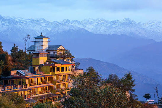
8 Himalayan Ranges from One Ridge • Motorcycle Ride Report Nepal Moto Tours • April 3–4, 2026 Ride Report by Prabhash Thakur Overview Field Details Ride Dates April 3–4, 2026 Duration 2 days / 1 night Start / End Point Kathmandu (loop) Total Distance ~130 km (outbound via Bhaktapur / Sankhu; return via Changunarayan descent to Bhaktapur) Daily Riding Time Day 1: ~2–3 hrs | Day 2: ~2 hrs riding + optional hike Riding Style Road / Valley Rim Difficulty ★☆☆☆☆ — Easy Max Altitude Nagarkot View Tower: 2,175m Overall Rating ★★★★★ Some rides are about the destination. Some are about the journey. The Ride to Nagarkot is emphatically about what happens at 5:48am on the morning of April 4th, when the sun clears the eastern ridgeline 175 kilometres behind Everest and the Himalayan range ignites from west to east in a sequence of pink, then gold, then brilliant white. Eight ranges simultaneously visible. A 360-degree panorama from the closest point accessible by motorcycle from Kathmandu. Two days, 130 kilometres, one sunrise. The Ride to Nagarkot is the shortest ride in the Nepal Moto Tours programme with the most specific purpose. Everything else is in service of that moment. The Route At a Glance Day Date Segment Accommodation Day 1 Apr 3 Kathmandu → Bhaktapur (Durbar Square) → Nagarkot (via Sanga or Sankhu road) Hotel at Nagarkot (view-room essential) Day 2 Apr 4 Pre-dawn sunrise at View Tower → Changunarayan descent hike (optional) → Bhaktapur → Kathmandu Kathmandu Suite Homes The route is a loop: outbound via Bhaktapur and the Sanga road, return via the Changunarayan descent and Bhaktapur again. The two legs are different in character and give Bhaktapur the double attention it deserves. Total riding time is under six hours across both days — the rest of the tour is for standing on a ridge, hiking through forest, eating juju dhau in a Newari courtyard, and watching the sun move across the highest mountain faces on earth. Day 1 — Kathmandu to Nagarkot via Bhaktapur (~65 km | 2–3 hrs) Depart Kathmandu mid-morning on Day 1 — there is no reason to rush on the outbound leg. The goal is to be on the Nagarkot ridge by late afternoon, with time for a walk, the sunset, and an early night in preparation for the 5am alarm. Leave around 9–10am after the worst of Kathmandu's morning traffic has dispersed. The Araniko Highway east is the obvious artery: straight out through Koteshwor, along the wide highway past the Thimi pottery settlements and into the approaches to Bhaktapur. The ancient city announces itself before you arrive: the brick pagoda rooflines visible above the highway road level, the air changing slightly as the modern highway strip gives way to something older. Stop in Bhaktapur. Bhaktapur Durbar Square deserves an unhurried hour. The finest example of Newari urban planning in Nepal — a medieval brick city that has survived earthquake, time and the relentless proximity of Kathmandu with its character intact. The 55-Window Palace of King Bhupatindra Malla, the Vatsala Temple, the Nyatapola five-storey pagoda — all in the same compact square, morning light on the brick facades, the rhythm of the city already at work around it. This is not a photo-stop. Give it the time it requires. From Bhaktapur the road continues east to Sanga, where the enormous white Shiva statue of the Sanga Ganesh Mandir stands on a hilltop above the junction. Turn left here for Nagarkot; the road begins climbing immediately. From ~1,400m at Sanga to 2,175m at the summit is 18 km of well-surfaced pine-forest switchbacks — one of the most enjoyable short mountain roads accessible from Kathmandu. In April the rhododendrons are in full bloom on the forested slopes alongside: red and deep pink against the pine green and the pale sky. There is no traffic to speak of once past the first 2 km from the junction. Ride it at whatever pace feels right and stop wherever the views demand. Nagarkot village and the ridge hotels appear at the top of the final climb. Check in. Confirm your room is north-facing — if it is not, ask to be moved. This is the non-negotiable accommodation requirement of this tour. A north-facing room means waking up on Day 2, opening the curtains before the 5am alarm, and seeing the Himalayan range already in pre-dawn silhouette above the valley. This single moment is worth the room change. Walk to the View Tower or the ridge north of it for the sunset. April 3 sunset is approximately 6:20pm. The western ranges — Ganesh Himal, Langtang — catch alpenglow in the 15 minutes after the sun drops: a diffuse pinkish-orange on the snow fields that shifts to mauve and then fades. Watch it in full. Dinner back at the hotel, early to bed. The alarm is set for 4:50am. Day 2 — Sunrise at the View Tower • Changunarayan hike • Bhaktapur return (~65 km riding + optional 3–4 hr hike) The alarm goes off at 4:50am. The View Tower is a five-minute walk from most ridge hotels. Do not miss this window. Nagarkot at 5am in April is cold — 6–8°C on the exposed ridge, with a northwest wind. Dress in every layer available: thermals, fleece, riding jacket zipped fully, gloves and neck gaiter. Carry the thermos of black tea. Walk to the View Tower and find a position on the north-facing side. The pre-dawn sky above the Himalayan horizon is already active: a deep violet-blue that is visibly brighter to the east, with the first ridge of the Mahalangur range appearing as a dark, jagged line where sky meets mountain. The lower peaks — Langtang Lirung, Ganesh Himal — are already visible as black silhouettes. Mount Everest is not yet identifiable; it is somewhere in the eastern darkness, 175 kilometres away. The light sequence at Nagarkot is predictable in its structure and impossible to anticipate in its effect. At approximately 5:30am the eastern horizon brightens from dark blue to grey-blue. The silhouettes of the near peaks sharpen. At 5:40am the first pink appears on the highest snow fields — Langtang Lirung's summit, then the near-western peaks. The pink deepens to orange as it moves east along the range. At approximately 5:48am the sun clears the eastern ridge and the full sequence fires: the central and eastern peaks ignite in gold — Gaurishankar, Dorje Lakpa, the Jugal Himal — and then the far eastern peaks emerge from darkness. Everest, on a clear April morning, is identifiable: a dark triangle above and to the left of the Mahalangur range, the highest point visible, standing alone above its neighbours. Not guaranteed on every April morning. When it is there, it is unmistakable. This sequence lasts approximately 15 minutes of maximum intensity. Then the light normalises, the colours become daylight colours, and the mountains settle into their daytime definition. The full panorama — 8 ranges, 300+ km of Himalayan ridgeline, in light — remains visible for several more hours on a clear April day. But the first 15 minutes after sunrise are why you came. Return to the hotel for breakfast. Eat well. The morning is still young and there are options for the rest of Day 2 before the return to Kathmandu. Day 2 continued — Changunarayan hike (optional, 3–4 hrs) The hike from Nagarkot to Changunarayan is one of the finest half-day walks accessible from a road-reachable overnight destination near Kathmandu. The trail descends from the View Tower through pine and rhododendron forest, emerges onto ridge terraces with Bhaktapur valley views below, passes through Tamang and Brahmin villages at intervals and reaches the ancient temple after approximately 3–4 hours of walking. The descent is gradual, the trail clear, and the cultural texture of the Tamang settlements along the way is worth more attention than the walking pace usually permits. Changunarayan temple itself — the oldest surviving Hindu temple in the Kathmandu Valley, its 464 AD Lichhavi stone inscription making it among the oldest dated inscriptions in South Asia — is dramatically undervisited compared to its significance. The carved wooden struts supporting the double-roofed pagoda are some of the finest Lichhavi-period woodwork in Nepal. The Vishnu images in the courtyard span several centuries of distinct artistic periods. Allow a full unhurried hour here. From Changunarayan, return to the bike at Nagarkot by taxi or local jeep (20–30 min), ride down to Bhaktapur for a final Durbar Square pass and juju dhau stop, then return to Kathmandu via the Araniko Highway. Back in Kathmandu by mid-afternoon. Tour complete. Riders who prefer not to hike: a leisurely morning on the ridge, a walk to the Kattike viewpoint, lunch at a Nagarkot cafe, then the direct descent to Bhaktapur and Kathmandu by midday. Both versions are entirely valid. The View Tower sunrise is the common centrepiece of both. The Bike Field Details Motorcycle Royal Enfield Himalayan 450 Engine 450cc Loaded Weight ~185 kg (minimal overnight kit) Tyre Setup Stock Modifications Luggage rack Bike Performance Notes The Himalayan 450 is excellent for this ride: the suspension and comfort suit the 18 km pine-forest climb perfectly, and the engine pulls smoothly on the sustained gradient without complaint. The descent from Nagarkot to Bhaktapur via Changunarayan involves a short section of unpaved track; the bike handled it effortlessly. No mechanical notes from this tour. The Nagarkot loop requires nothing that a competent rider on any motorcycle above 125cc cannot manage — this is the programme's most accessible route for newer riders who still want a genuinely memorable Nepal motorcycle experience. Road & Trail Conditions Section Surface Notes Kathmandu → Bhaktapur (Araniko Highway) Paved — busy ~15 km. Congested through Koteshwor and Thimi in the morning; clear by 8am. Once past Bhaktapur the traffic drops dramatically Bhaktapur → Sanga junction Paved — good The Sanga Ganesh Mandir hilltop with its massive white Shiva statue is visible from the road. Turn left at Sanga junction for the Nagarkot climb Sanga junction → Nagarkot Paved — winding uphill ~18 km of sustained but well-surfaced climb through pine forest from ~1,400m to 2,175m. Classic motorcycle ascending road: consistent grade, sweeping curves, good visibility. The road narrows slightly near the summit Sankhu alternative route Paved — longer, quieter Via Bouddha and Sankhu: adds ~10 km but avoids Bhaktapur traffic entirely. Quieter road through the northern valley; passes Sankhu Vajrayogini Temple. Excellent outbound option for those who prefer uncrowded riding Nagarkot → Changunarayan (hike) Foot trail — 3–4 hrs Descending hike from the View Tower through Tamang villages, forest, and terraced farmland to Changunarayan UNESCO temple. Pick up the bike in Nagarkot for the return; walk one way, ride back Changunarayan → Bhaktapur (by bike, Day 2 return) Paved / narrow track Changunarayan sits above Bhaktapur at ~1,550m; a short 8 km descent returns to Bhaktapur for the Durbar Square visit and Kathmandu return Bhaktapur → Kathmandu Paved — busy Return via Araniko Highway; manageable mid-morning The Sanga–Nagarkot climb is one of the best-maintained mountain approach roads in the Kathmandu Valley. April conditions are reliable: dry surface, minimal gravel debris, clear road edges. The only caution is traffic on the climb between 9am and noon when tourist buses and jeeps are ascending — departing Bhaktapur before 9am avoids the main vehicle window. The descent via Changunarayan involves one optional trail section that mountain bikers rate as technical; on a motorcycle, use the road descent from the temple to Bhaktapur (signposted). The Himalayan Panorama from Nagarkot The View Tower at Nagarkot (2,175m) is positioned on an isolated ridge separating the Kathmandu Valley from the Indrawati Valley to the north, with an unobstructed northward sightline to the high Himalaya. Eight of Nepal's thirteen Himalayan ranges are visible on a clear morning — the widest accessible panorama within one hour's motorcycle ride of the capital. Peak Altitude Direction from Nagarkot Annapurna I 8,091m West — distant but unmistakable on clear April mornings Manaslu 8,163m West-northwest Ganesh Himal 7,422m Northwest — dominates the near horizon on the western side Langtang Lirung 7,234m North — closest major peak, prominent and near Dorje Lakpa 6,966m Northeast Gaurishankar 7,134m East — the double-headed peak visible in clear April air Numbur Himal 6,957m East-southeast Mount Everest 8,848m East-northeast, ~175 km distant — visible on very clear April mornings as a dark triangle above the Mahalangur range. Not guaranteed but genuinely possible from the View Tower April 4 sunrise note: sunrise at approximately 5:48am. Arrive at the View Tower by 5:15–5:20am to secure a good north-facing position and experience the full pre-dawn colour build. The most intense colour sequence lasts 10–15 minutes after the sun clears the eastern ridge. Cloud on the western ranges (Annapurna, Manaslu) can form by 8–9am in April — the early window is the reliable one. Weather & Conditions Factor Details Season Spring (early April) — one of the two optimal windows for Nagarkot Temperature Kathmandu: 22–28°C daytime. Nagarkot summit: 12–20°C daytime; 5–10°C overnight; pre-dawn at the View Tower: 6–8°C Mountain visibility April delivers clear pre-monsoon skies most mornings. Visibility typically excellent at dawn; afternoon haze builds as temperatures rise. Arrive at the View Tower by 5:30am for the best window Rhododendron bloom April is peak rhododendron season on the ridges and forest trails around Nagarkot — red and pink above the road on the climb, visible on the Changunarayan descent trail Wind Cool ridge wind at the View Tower at dawn. Bring a windproof layer for the pre-sunrise wait Rain risk April is generally dry in the Kathmandu Valley; occasional pre-monsoon afternoon thunderstorm possible but rare. Morning weather is reliably clear Sunrise time April 3–4: sunrise at approximately 5:48–5:50am. Arrive at the View Tower by 5:15–5:20am for the full pre-dawn colour sequence April 3–4 sits at the sweet spot of the spring riding window — warm enough for comfortable riding, clear enough for mountain views, rhododendrons still in bloom on the ridge. The one variable that cannot be controlled is morning cloud cover at the View Tower: April mornings are reliably clear in most years but not in all. If cloud is present at dawn, wait. April cloud at Nagarkot often burns off within 30–45 minutes of sunrise. If it persists, the walk to Changunarayan and the Bhaktapur visit remain excellent independent of the mountain view. Highlights This is the most focused ride in the Nepal Moto Tours programme. The highlights accumulate quickly: Stop Why It Matters Bhaktapur Durbar Square Nepal's finest medieval city centre — a UNESCO World Heritage Site of brick temples, carved courtyards and the 55-Window Palace of the Malla kings. Morning light on the Durbar Square before the day-trippers arrive is exceptional. The motorcycle ride from Kathmandu to Bhaktapur along the Araniko Highway is the approach road the city deserves Sanga Ganesh Mandir The enormous white Shiva statue on a hilltop above Sanga is visible from the Araniko Highway below. A quick stop at the temple complex with its giant sculpture offers Kathmandu valley views and a vivid cultural landmark The Nagarkot climb From Sanga to the summit: ~18 km of sustained pine-forest switchbacks on a well-surfaced road. This section is the motorcycle highlight of the tour — each successive hairpin reveals a wider view of the valley below and the first glimpses of mountain ridgelines ahead. The road is empty enough in April morning to ride at your own pace Nagarkot View Tower (2,175m) The summit observation tower with a 360-degree platform. At dawn on a clear April morning, eight Himalayan ranges are simultaneously visible: Annapurna, Manaslu, Ganesh Himal, Langtang, Jugal, Rolwaling, Everest range, Numbur range. Everest is visible as a dark triangle on exceptionally clear mornings. This is the stated purpose of the entire tour Sunset from the hotel terrace April 3 sunset: approximately 6:20–6:25pm. The western ranges — Ganesh Himal and Langtang — catch alpenglow (pinkish-orange light on snow) in the 15 minutes after the sun drops below the Kathmandu Valley rim. Watch it from the hotel terrace with tea or something stronger Changunarayan Temple (Day 2 hike) The oldest Hindu temple in the Kathmandu Valley, dedicated to Vishnu, dating from the 4th–5th century AD (464 AD Lichhavi inscription — the oldest stone inscription in Nepal). A UNESCO World Heritage Site perched on a wooded hilltop above Bhaktapur. The 3–4 hour hike from Nagarkot passes Tamang villages, terraced farmland in spring and rhododendron forest before arriving at the ancient carved courtyard Bhaktapur Durbar Square (Day 2 return) A second pass through Bhaktapur on the return — this time in the afternoon light, which illuminates the brick temple facades differently from the morning visit. Stop for Bhaktapur's famous juju dhau (king curd) in clay pots at a courtyard shop before riding back to Kathmandu Nagarkot ridge trail (optional) A 45-minute walk along the ridge north of the View Tower leads to the Kattike viewpoint, with the same Himalayan panorama and fewer visitors. Excellent for early-morning photography before the sunrise crowds arrive at the main tower The dawn light sequence at the View Tower: dark violet sky → grey-blue silhouettes → first pink on Langtang → orange sweeping east → full gold ignition across the range. Fifteen minutes that justify the overnight stay The Sanga–Nagarkot pine-forest climb: 18 km of empty April road with rhododendrons in bloom alongside and the Kathmandu Valley gradually revealed below on the switchbacks Bhaktapur Durbar Square without the afternoon crowds — morning light on the brick pagodas, the city already at work, the medieval architecture in full morning shadow and shine The Changunarayan descent hike: Tamang villages, terraced fields, ancient carvings at the end, and the specific quality of walking through forested Nepal in spring that no road can deliver Juju dhau twice in two days: this is correct behaviour in Bhaktapur and should not be apologised for Lowlights & Challenges The Bhaktapur traffic approach on the outbound can be slow if departing Kathmandu after 9am. Leave earlier or accept 20–30 minutes of stop-start riding before the highway clears Mountain view is not guaranteed. April is excellent but not infallible — cloud can obscure the panorama on any given morning. There is no refund available from the weather. The alternative — Bhaktapur, Changunarayan, the climb road in rhododendron bloom — is not a consolation prize, but the sunrise is the reason for the overnight and its absence is felt Nagarkot is one of the most popular overnight destinations from Kathmandu and its hotels reflect that in pricing. Budget options are limited to basic rooms without views — which defeats the purpose. Mid-range hotels with north-facing rooms are the minimum for this tour. Book early for April weekends The cold at the View Tower at 5am is genuine: 6–8°C on the exposed ridge with wind. Riders who did not bring warm layers will be uncomfortable enough to shorten the experience. A fleece mid-layer, gloves and a neck gaiter are not optional The Changunarayan hike cannot be completed and the bike ridden down simultaneously without transport logistics. Either hike down and arrange a local jeep back to Nagarkot for the bike, or ride down directly and miss the trail. Both are valid; the logistics need a decision before departing the View Tower Food & Tea Houses Stop What to Eat / Experience Bhaktapur (Day 1 morning) Juju dhau — the famous Bhaktapur 'king curd' served in fired clay pots, available from early morning at shops near the Durbar Square. Thicker and richer than Kathmandu curd; genuinely excellent. A pre-ride ritual that Bhaktapur insists upon Sanga junction canteen Basic tea and sel roti at the junction before the climb. Nothing special but the right fuel before 18 km of uphill riding Nagarkot cafes / lodges Nagarkot has a good selection of restaurants ranging from hotel dining rooms to small cafes along the ridge road. Dal bhat is excellent at the mid-range lodge dining rooms; the local bread (roti) with honey and curd makes a good light dinner if the evening is being saved for the sunset. Ask wherever you eat for tea with mountain views — most ridge restaurants have terraces facing north Pre-sunrise nothing Do not eat a full meal before the 5am View Tower walk. Bring a thermos of black tea or coffee, a muesli bar if needed. The cold and the altitude and the darkness make a heavy meal counterproductive. Breakfast properly after the sunrise, back at the hotel Post-sunrise breakfast Return to the hotel for a full breakfast after the View Tower. April mornings at Nagarkot are beautiful for 2–3 hours after sunrise — the light on the mountains, the rhododendrons on the slopes, the valley below gradually emerging from haze. Eat slowly. There is time Tamang village tea houses (hike) The Changunarayan descent trail passes through Tamang settlements where small tea houses serve chiya (sweet tea), chiura (beaten rice), and eggs. These are informal stops with no menus — simple, warm, and perfectly calibrated for a mid-hike rest Changunarayan lunch Small restaurants below the Changunarayan temple serve dal bhat and noodle dishes. Eat here before riding down to Bhaktapur Bhaktapur juju dhau (Day 2) A second juju dhau before the return to Kathmandu. Different shop, same clay pot, same quality. Bhaktapur earns two visits Accommodation Location Where We Stayed / Recommendation Nagarkot (Night 1) Any hotel on the north-facing ridge with a mountain-view room. Specific recommendations: Nagarkot Shangrila Resort (mid-range, good views), Club Himalaya Nagarkot (comfortable, reliable, view rooms), or simply any guesthouse that can confirm a north-facing window. The room view is the non-negotiable: wake up, open the curtains, see the Himalayan range from bed. This is the point of the overnight stay and a south-facing room negates it entirely. Book well ahead in April — Nagarkot fills on weekends and during the spring season Kathmandu (return night) Kathmandu Suite Homes The one non-negotiable accommodation rule for this tour: the room must face north. A south-facing room at Nagarkot means a hotel room in a hill town. A north-facing room means a window onto the Himalayan range from bed. When booking, confirm this explicitly and request the specific room. If the hotel cannot confirm a mountain-view north-facing room, choose a different hotel. Permits & Entry Fees Bhaktapur Durbar Square entry: NPR 1,500 per foreign national (NPR 300 for SAARC nationals). Pay at the main entrance gate. The fee includes access to the full square complex Changunarayan Temple: small entry fee (NPR 100–300) Nagarkot View Tower: free No motorcycle permits required for this route. No conservation area or restricted zone Motorcycle registration papers as standard Tips for Riders Planning This Route Book a north-facing mountain-view room at least two weeks ahead for April weekends. Nagarkot fills and the best rooms go first Set the alarm for 4:50am without negotiation. The View Tower walk takes 5 minutes; the colour sequence starts before 5:30am. Missing the pre-dawn is missing the point Bring every warm layer you have for the View Tower. The ridge wind at 5am is not the same as the valley temperature you packed for. A fleece, a riding jacket, a neck gaiter and riding gloves are the minimum Carry a thermos of hot tea or coffee for the pre-dawn wait. The View Tower has no catering at 5am and the cold makes a hot drink feel genuinely important Depart Kathmandu before 9am on Day 1. The Araniko Highway approach to Bhaktapur clears considerably by 8–8:30am; traffic after 9am adds 20–30 minutes to a straightforward journey Take the Sanga road outbound and the Changunarayan–Bhaktapur road on return for maximum variety. The two directions of the loop are genuinely different experiences Budget NPR 6,000–8,000 for the 2-day loop: mid-range hotel ~NPR 3,000–4,500, meals ~NPR 1,500, entry fees ~NPR 1,800, incidentals The Kattike viewpoint (45-minute ridge walk north from the View Tower) offers the same Himalayan panorama with fewer visitors. If the main tower is crowded on the morning of April 4, walk to Kattike instead for the sunrise If cloud obscures the View Tower at dawn, wait 30–45 minutes before abandoning the spot. April cloud at Nagarkot regularly clears within an hour of sunrise Do not rush through Bhaktapur on the outbound. It is one of the finest ancient cities in Asia and the motorcycle provides the exactly right way to arrive there: through the approaches on the Araniko Highway, past the rice paddies, into the old city at street level. Give it the hour it earns Emergency & Practical Information Item Details Mobile Signal Excellent throughout. Kathmandu, Bhaktapur, the Nagarkot climb and the ridge all have strong NTC and Ncell coverage. No signal gaps on this route ATM Bhaktapur (multiple), Kathmandu before departure. Nagarkot has some ATMs in the village but carry sufficient cash from Kathmandu. NPR 5,000–6,000 covers 1 night accommodation, all meals, entry fees and incidentals comfortably Entry Fees Bhaktapur Durbar Square charges foreigners NPR 1,500 (SAARC NPR 300). Changunarayan Temple charges a small entry fee. Nagarkot View Tower is free. Budget accordingly Medical Nagarkot has no hospital; nearest facility is in Bhaktapur or Kathmandu. This is a low-risk, low-altitude route. A standard first-aid kit is sufficient Altitude 2,175m at the View Tower — negligible altitude sickness risk for most riders. A mild headache and thirst in the pre-dawn cold are possible; water and warm clothing are the mitigation Road hazards The Nagarkot climb above Sanga has occasional large vehicles (tourist buses) in peak season. Stay left and use your horn on blind corners. The descent to Changunarayan by bike (if not hiking) is winding; standard downhill caution applies Sunrise guarantee Clear visibility at dawn is not guaranteed. April is excellent but not infallible. If the View Tower is in cloud on Day 2 morning, wait 30–45 minutes — April cloud often clears. If it does not clear by 7am, the hike to Changunarayan and the Bhaktapur visit remain excellent independent of the mountain view Final Verdict Would we recommend this ride? Without any reservation whatsoever. The Ride to Nagarkot is the programme's most accessible and most laser-focused tour. Two days. One hundred and thirty kilometres. Three stops worth deep attention: Bhaktapur, the View Tower, Changunarayan. One sunrise that is the documented reason for the overnight stay. Everything else is logistics, road, and the enjoyment of the Sanga–Nagarkot climb in rhododendron season. April is the right month for this ride. The spring air is clear enough for eight Himalayan ranges, warm enough for comfortable riding, and the forest on the approach is pink-and-red with bloom. The View Tower at 5:48am on April 4th delivers what it promises: Ganesh Himal, Langtang, Gaurishankar, Dorje Lakpa, the Jugal range, the Rolwaling peaks, and — on a clear morning, which April usually provides — the unmistakable dark triangle of Everest standing above everything else in the eastern distance. The entire morning sequence at Nagarkot — from the pre-dawn violet sky to the first pink on Langtang to the full gold ignition across the range — takes fifteen minutes. It requires one overnight stay, one pre-dawn alarm, and one properly booked north-facing room. The Nepal Moto Tours programme includes rides of ten days to Lo Manthang, five days to Manang, four days to Pattale. The Ride to Nagarkot is two days. All of those tours are worth doing. So is this one. ★★★★★ Ride Report by Prabhash Thakur | Nepal Moto Tours | Published April 2026 Tags: Nagarkot • Sunrise • Himalayan Panorama • Bhaktapur • Changunarayan • Kathmandu Valley • Nepal Weekend Ride • View Tower
Pokhara to Ghandruk Motorcycle Ride Report | Nepal Moto Tours

Pokhara to Ghandruk Motorcycle Ride Report | Nepal Moto Tours

Into the Annapurna Foothills in Rhododendron Season • Motorcycle Ride Report Nepal Moto Tours • March 4–5, 2026 Ride Report by Prabhash Thakur Overview Field Details Ride Dates March 4–5, 2026 Duration 2 days / 1 night Start / End Point Pokhara (loop) Total Distance ~120 km return (via Nayapul / Kimche road) Daily Riding Time Day 1: ~3–4 hrs | Day 2: ~2–3 hrs (after morning village exploration) Riding Style Road / Off-road Mountain Track Difficulty ★★★☆☆ — Moderate to Challenging (Birethanti–Ghandruk section) Max Altitude Ghandruk village: 2,012m Overall Rating ★★★★★ The Pokhara to Ghandruk ride is the only tour in the Nepal Moto Tours programme that starts from Pokhara — and that distinction matters. It does not begin with a highway transit; it begins at the edge of the Annapurna Conservation Area, ten kilometres from the Pokhara lakeside, and climbs into the Himalayan foothills through one of the richest concentrations of Gurung culture remaining in Nepal. By the time the pavement ends at Birethanti, the ride has already changed character. By the time the bike is parked at Ghandruk's entrance and the stone lanes of the village open ahead, it has become something else entirely: not a motorcycle route, but an approach into a living Gurung community at 2,012 metres, with Annapurna South filling the northern sky and Machapuchare's sacred double summit to the east. March is the right month for this. The rhododendrons are at peak bloom on the Birethanti–Ghandruk track — crimson and deep pink through the forest that lines the jeep road above the Modi Khola. The mountains are in sharp pre-monsoon definition. The nights are cold enough to appreciate a warm lodge kitchen. And there are fewer trekkers on the track in early March than the spring peak weeks that follow. The Route At a Glance Day Date Segment Accommodation Day 1 Mar 4 Pokhara → Baglung Highway → Nayapul → Birethanti → Kimche → Ghandruk Ghandruk Lodge / Annapurna Guest House Day 2 Mar 5 Sunrise viewpoint • Gurung Museum • Village walk → Kimche descent → Nayapul → Pokhara Pokhara accommodation The route is an out-and-back loop from Pokhara: outbound via the Baglung Highway to Nayapul, then off-road through Birethanti and Kimche to Ghandruk; return via the same track. No alternative return route exists — the Ghandruk approach track is the only motorcycle-accessible road to the village, and it is the same road in both directions. The two-directional ride is different in experience: the climb focuses attention on the track itself; the descent opens up the valley views and gives the rider more time to look around. Day 1 — Pokhara to Ghandruk (~60 km | 3–4 hrs) Collect permits from the ACAP/TIMS office in Pokhara Lakeside before departure. The office opens at 9am; the ride can begin by 9:30–10:00am and still reach Ghandruk with several hours of daylight remaining. Do not skip this step: the Birethanti ACAP checkpoint is active, the permit check is real, and missing the permit means a return to Pokhara. The Baglung Highway leaves Pokhara's western suburbs and immediately becomes a different road from the city traffic: a well-surfaced highway tracking the Modi Khola valley southwest through terraced farmland and Gurung-Magar village country. Phewa Tal is briefly visible behind on the departure. Machapuchare sits on the northern horizon for the entire early section — the Fishtail's double summit, clean and sharp in March morning air, appears to follow the road as the valley curves. This is the easiest and most enjoyable 42 km of the tour. Nayapul is the end of the comfortable highway section: a small junction town where the Baglung Highway crosses the Modi Khola and the Annapurna trekking world begins in earnest. The first trekkers are visible here, loading up at tea houses, checking permit papers at the ACAP gate. From Nayapul, 3 km of rougher track leads to Birethanti at the Modi Khola bridge — the classic trailhead that has dispatched tens of thousands of ABC and Poon Hill trekkers over the decades. Stop at Birethanti: present permits at the ACAP checkpoint, fill the water bottle, assess the track ahead. The jeep road to Ghandruk begins beyond the bridge. The pavement is already gone by the first bend. The track climbs immediately and steeply: loose rock, tight corners, the Modi Khola valley opening below to the right. In March the rhododendron forest begins almost at once — the red and pink bloom overhead through the trees, the track intermittently shadowed and then opening onto exposed sections with valley views. This is not the track for distracted riding. The surface changes constantly: packed dirt, then loose rock, then a stream crossing, then a brief improved section, then back to rock. Maintain forward momentum on the steeper sections and choose your line carefully on loose corners. Kimche at approximately 1,640m is the natural mid-point rest stop: a small cluster of tea houses where the track briefly levels. Take water, assess conditions, and confirm you have enough fuel for the final Ghandruk push. The section from Kimche to the Ghandruk parking area is the most technically demanding of the ride: a sustained steep climb on rocky track with the tightest switchbacks of the route. On a Himalayan 450 in March dry-season conditions, it is manageable with confidence and patience. Take it at the bike's pace, not at the speed ego suggests. The parking area at Ghandruk's entrance appears after the final steep section: a flat clearing where jeeps disgorge trekkers and locals. Park the bike, switch off the engine, and walk into the village. The stone-paved stairway descends into the old Gurung settlement, and what appears in front of you — the terraced stone houses, the prayer flags across every roof, the narrow lanes between slate-roofed buildings that have stood for generations, and above all of it, filling the northern sky with a scale that requires a conscious recalibration, the white wall of Annapurna South — is one of the finest first sights of any two-day ride in Nepal. Check in before 3pm. The afternoon terrace is the right place to spend the remaining daylight: tea, the peaks, the valley below, the village sounds. In March the light on Annapurna South from 4pm onwards transitions through gold, amber, orange and pink before the summit loses the sun and the sky behind it deepens to clear violet. This is not a guidebook description. It is what actually happens, and it is worth watching in full. Day 2 — Sunrise • Village Exploration • Return to Pokhara The alarm at 5:30am. The walk to the sunrise viewpoint above the upper lodges takes 10–15 minutes on the stone path. The air at this hour in March is cold — 3–4°C with a light upvalley breeze. Dress fully: thermals, fleece, jacket. Carry the thermos of tea that the lodge prepared at your request the previous evening. The viewpoint above Ghandruk at pre-dawn in March is one of the most concentrated mountain experiences in the Nepal Moto Tours programme. The three peaks are already silhouetted in the pre-dawn: Annapurna South enormous and direct ahead to the north, Hiunchuli's sharp point to the west, and Machapuchare's double-summit distinctive against the eastern sky. The alpenglow begins before the sun rises: Annapurna South's summit snowfields catch the first light at approximately 5:50am — a faint pink that deepens quickly to orange, then gold, as the sun rises behind the eastern ridge. The sequence on Machapuchare is different: the Fishtail catches colour from its eastern face while the western side remains in shadow, and for several minutes the mountain glows on one side only. The lower slopes of the village, still dark, frame the illuminated peaks in a composition that the photographers who come here specifically for this shoot know and return for. By 6:30am the light has normalised and breakfast is appropriate. The lodge kitchen will be ready. Eat well, then spend the morning in the village. The Gurung Cultural Museum is the essential Day 2 stop: a modest building but a genuine cultural document. The displays cover Gurung traditional dress (the distinctive patuka belt and cholo), farming implements, household tools, Gurkha regiment weapons and photographs of Ghandruk men who served in the British and Indian armies, and explanations of the Gurung social and ritual calendar. The Gurung people are the dominant community of this region and many of the men visible in the village today are ex-soldiers — retired Gurkha veterans living their post-service years in the same stone-house community their grandparents inhabited. The museum contextualises this continuity. Allow 30–40 minutes. After the museum, walk the village lanes without agenda. The stone paths connect the terraced house levels with steps that have been worn smooth by generations of use. Old women in traditional dress weave on doorstep looms. Monastery bells sound from the gompa above the main lane. Children pass in school uniform. Prayer wheels line the wall above the main water source. The village operates at its own rhythm and that rhythm is not adjusted for visitors. Walk within it, not through it. Depart Ghandruk for Pokhara by 11am at the latest. The return descent to Birethanti takes 1.5–2 hours; the highway return from Nayapul to Pokhara another hour. Back in Pokhara by early afternoon. The Bike Field Details Motorcycle Royal Enfield Himalayan 450 Engine 450cc Loaded Weight ~190 kg (light kit for 2-day ride) Tyre Setup Stock Modifications Bash plate, luggage rack Bike Performance Notes The Birethanti–Ghandruk track is the most technically demanding riding section in this tour and the one that genuinely tests the Himalayan 450's off-road capability. The engine's low-end torque is the critical asset on the steep sustained sections above Kimche — the bike pulls cleanly through the rocky sections in first and second gear without the strain that would affect a smaller machine. The bash plate absorbed rock strikes on the lower track. Ground clearance was tested once on a deep cross-track rut near Kimche; the bike cleared it without grounding. The return descent required sustained brake use — no fade noted, but this section warrants attention on a heavily loaded bike or in warm afternoon conditions. Rider note: the Ghandruk track is recommended for riders with genuine off-road experience. It is not a technical extreme; it is sustained, steep, loose and unforgiving of inattention. Riders who are not comfortable with low-speed rocky climbs and tight switchbacks should arrange a local jeep from Birethanti and ride the Baglung Highway section only. Road & Trail Conditions Section Surface Notes Pokhara → Nayapul (Baglung Highway) Paved — good ~42 km. A pleasant river-valley highway running southwest from Pokhara. Follows the Seti Gandaki / Modi Khola valley. Light traffic beyond the Pokhara outskirts. Phewa Tal visible to the right briefly on departure Nayapul → Birethanti Paved / compact track A brief 3 km section crossing the Modi Khola suspension bridge at Birethanti. This is the classic trekkers' trailhead; expect foot traffic around the ACAP checkpoint Birethanti → Kimche Rough jeep track — off-road The road character changes completely at Birethanti. A rocky, narrow jeep track climbs steeply through forest with tight switchbacks, occasional stream crossings and loose rock sections. In March (dry season) it is manageable on a competent machine; in monsoon it becomes significantly more challenging. 18–22 km/h average speed Kimche → Ghandruk parking Rough track — steep Final 5–8 km section beyond Kimche is the most technically demanding of the route. Steep incline, rocky surface, tight hairpins. 4WD jeeps use this section; a motorcycle requires confident off-road technique. Park at the upper lot near the village entrance Ghandruk upper village — on foot Stone-paved paths The village itself is connected by steep stone stairways. No motorcycle access into the old village lanes. Park at the entrance and walk Return (Ghandruk → Pokhara) Same route in reverse The descent from Ghandruk to Birethanti is faster but requires disciplined braking on the steep switchbacks. Brake fade is possible on a loaded bike if descending too quickly; take your time March is the best season for the Ghandruk track: dry conditions, no monsoon mud, no post-rain loose surface on the steep sections. The track is at its most stable and predictable in the March–May window. Check with local jeep operators in Pokhara about current upper-section conditions before departing — occasional rockfall from the cliffs above the track can create temporary blockages that clear within hours, but are worth knowing about before you commit to the off-road section. The Annapurna View from Ghandruk Ghandruk's position on a south-facing ridge spur above the Modi Khola valley gives it a direct northward sightline to the inner Annapurna sanctuary peaks. The view from the village is not a panoramic sweep of the Himalayas — it is an intimate, face-to-face encounter with three specific peaks at close range. Annapurna South fills the sky to the north. Hiunchuli stands to the west. Machapuchare, sacred and untouched, rises to the east. The distance between the village and the peaks is much shorter than most Himalayan viewpoints, which gives Ghandruk its particular quality: these mountains do not look distant. They look immediate. Peak Altitude Notes Annapurna South 7,219m The dominant presence above Ghandruk — fills the northern sky directly above the village. In March, its south face is in snow Hiunchuli 6,441m West of Annapurna South; the sharply pointed peak visible to the left of the main Annapurna massif from the village Machapuchare (Fishtail) 6,993m The sacred, never-climbed double-summit peak to the north-east. The most iconic silhouette in the Pokhara / Ghandruk skyline. The Nepalese government has never permitted an ascent; it remains a protected spiritual summit Gangapurna 7,455m Visible to the north, above the Modi Khola valley Annapurna III 7,555m Northern horizon Annapurna I (distant) 8,091m On exceptionally clear March mornings, the main Annapurna summit is visible further north above the range The Machapuchare note deserves its own paragraph. The mountain's Nepal Tourism Board listing as 'not permitted for climbing' is the functional description, but the reason is deeper: Machapuchare is sacred to Shiva and the local Gurung and Magar communities have long regarded it as a dwelling of the gods. A single British expedition reached the lower summit in 1957; the summit itself was not reached and the government subsequently closed the peak entirely. Standing in Ghandruk in March and looking at that double summit — immaculate, human footprint-free, the light catching its east face at dawn while its west is still dark — the prohibition makes a different kind of sense. Weather & Conditions Factor Details Season Early spring (March) — one of the two optimal windows for Ghandruk Pokhara / Nayapul Warm and clear; 20–27°C daytime. March mornings in Pokhara are reliably clear with excellent mountain views from the lakeside Ghandruk (2,012m) Pleasantly cool; 10–18°C daytime, 2–6°C overnight. Warm riding jacket at night is essential Rhododendron bloom March is prime rhododendron season in the Annapurna foothills. The forest between Birethanti and Ghandruk carries crimson and pink bloom on the hillsides — one of the most vivid spring landscapes in Nepal Mountain visibility March delivers excellent pre-monsoon clarity. Annapurna South, Hiunchuli and Machapuchare are in sharp definition. The Modi Khola valley framing below and the snow fields above create the signature Ghandruk composition Wind Light and manageable. March is not the windy season in the Annapurna foothills — unlike the Kali Gandaki corridor, Ghandruk sits in a more sheltered Modi Khola valley position Sunrise time March 5: sunrise approximately 6:10–6:15am. At Ghandruk, sunrise on the peaks occurs before the sun itself appears — the first alpenglow on Annapurna South begins around 5:50am. Be at the viewpoint by 5:40am March 4–5 sits at the beginning of the spring climbing and trekking season. The Annapurna conservation area is at its most visually spectacular: clear mountain skies, rhododendron forests in bloom, and the valley below still green from the winter rains. Temperature management across the two days spans 27°C in Pokhara on departure and 3°C at the Ghandruk viewpoint at 5:30am the following morning. Pack for both. Permits Required The Ghandruk ride enters the Annapurna Conservation Area. Both permits below are mandatory and checked at the Birethanti ACAP checkpoint. Arrange them in Pokhara before departure. Permit Cost (2026) Where to Obtain ACAP (Annapurna Conservation Area Permit) NPR 3,000 (foreigners) / NPR 1,000 (SAARC) ACAP/TIMS counter, Pokhara (Lakeside / tourist area). Or at the ACAP checkpoint in Birethanti if not obtained in Pokhara — but do not rely on this; get it before departing TIMS Card NPR 2,000 (foreigners) Same office as ACAP in Pokhara Permits require a passport-sized photo each — carry two photo-booth prints from Pokhara before the ACAP office Physical originals required at the Birethanti checkpoint and at any secondary checks en route. Photocopies are not accepted Nepal citizen riders do not require ACAP or TIMS permits Motorcycle registration papers at all times Highlights The Ghandruk ride is defined by the quality of its arrival: the moment the stone lanes open and Annapurna South fills the sky. Everything that leads to that moment — the Baglung Highway, the rhododendron track, the Kimche climb — earns it. Stop Why It Matters Baglung Highway (Pokhara to Nayapul) One of Nepal's most pleasant highway sections: the Modi Khola valley alongside, terraced fields on the hillsides, Machapuchare visible to the north on clear March mornings. A warm-up ride that doubles as one of the finest scenic valley roads near Pokhara Birethanti ACAP checkpoint The Annapurna Conservation Area entry point at the Modi Khola bridge. An atmospheric trekker hub where hundreds of ABC and Poon Hill trekkers begin their journeys. Present permits here; the jeep track begins beyond the bridge Birethanti–Kimche off-road section The defining riding section of the tour. The moment the pavement ends and the jeep track begins, the ride changes from pleasant highway to genuine off-road mountain work. Dense rhododendron forest above the track in March; the crimson and pink bloom visible through the trees as the road climbs Kimche village A small waypoint at approximately 1,640m where the track broadens briefly. Good stop to assess conditions and take water before the final Ghandruk push Ghandruk sunrise viewpoint Above the upper village lodges: direct face-to-face view of Annapurna South, Hiunchuli and Machapuchare at first light. The alpenglow sequence on these three peaks in the 15 minutes around 6am on a clear March morning is one of the finest mountain photography positions in Nepal outside of the trek itself Ghandruk village lanes Stone-paved stairways connecting the terraced houses of the Gurung community. Slate-roofed stone buildings, prayer flags, monastery bells, chortens, and ex-Gurkha veterans on their morning walks. The village has been inhabited continuously for centuries and it shows in the material culture of every building Gurung Cultural Museum A small but excellent museum in the old village core documenting Gurung history, Gurkha regiment service, traditional dress, weaving tools, weapons, and ritual objects. Entry fee: NPR 100–200. Allow 30–40 minutes. The context it provides for the village walk that follows it is considerable Annapurna Guest House terrace The best-positioned lodge terrace in Ghandruk for the Annapurna South / Machapuchare view. Order evening tea here regardless of where you are staying. The view from this terrace as the peaks go from gold to amber to purple at sunset is the defining visual memory of the tour Komrong Danda viewpoint (optional hike) A 45-minute walk from Ghandruk gives a 360-degree panorama of the Modi Khola valley, the Annapurna sanctuary approach and the full Ghandruk village spread below. Optional but rewarding if time and energy allow on Day 2 morning before the return The rhododendron forest on the Birethanti–Ghandruk track in March: crimson and pink bloom above the rough jeep road, the Modi Khola visible in the valley below through the trees. This section is at its most vivid in early-to-mid March and the colour from a motorcycle riding slowly through it is extraordinary The first walk into Ghandruk after parking the bike: stone stairs, prayer flags, the sound of monastery bells, and then Annapurna South enormous and immediate above the northern edge of the village. The scale transition from the jeep track to this view requires a moment to absorb The sunrise alpenglow on Machapuchare's east face: one side pink and gold, one side in shadow, the double summit catching the dawn asymmetrically before the full light arrives. This specific quality of the March early-morning view from Ghandruk is documented by trekkers and photographers across dozens of travel reports and is genuinely as good as described The Gurung Museum and village lane walk in the morning: ex-Gurkha veterans on their morning circuits, women weaving on doorstep looms, the gompa bell sounding above the old lane. This is a living village, not a heritage display, and the difference is felt immediately The Baglung Highway in March morning light: Machapuchare following the road north, the Modi Khola alongside, the valley green and clear. Nepal's most underrated short highway section Lowlights & Challenges The Birethanti–Ghandruk track is not suitable for inexperienced off-road riders. Steep, rocky, tight and unforgiving, it has a jeep-track character that demands active technique rather than passive road riding. Riders without off-road confidence should arrange a jeep from Birethanti Foot traffic on the track is a constant management task. Trekkers, mule trains and local villagers all share the jeep road below Kimche. The track is narrow in sections and a loaded motorcycle approaching a mule train on a steep blind corner is a situation that requires stopping, not negotiating at speed. Yield always to mules — always on the uphill side The return descent from Ghandruk to Birethanti requires sustained brake discipline. The same switchbacks that were climbed in first gear now require careful braking on a loaded bike. Take the descent at the speed the road warrants, not the speed the open sections suggest Ghandruk in spring trekking season (mid-March onwards) becomes genuinely busy. The best-view lodges fill early. Riding in on March 4 — the first weekend of March — captures the season's beginning before the main crowd arrives; by March 15–20 the village is significantly busier. This tour's March 4 timing is well-chosen No motorcycle can enter the stone-paved village lanes. The bike parks at the entrance and the rest is done on foot. Pack a small daypack for the village walk and lodge overnight kit No ATM above Nayapul. Carry all necessary cash from Pokhara Notable Stops Along the Way Stop Why It Matters Baglung Highway (Pokhara to Nayapul) One of Nepal's most pleasant highway sections: the Modi Khola valley alongside, terraced fields on the hillsides, Machapuchare visible to the north on clear March mornings. A warm-up ride that doubles as one of the finest scenic valley roads near Pokhara Birethanti ACAP checkpoint The Annapurna Conservation Area entry point at the Modi Khola bridge. An atmospheric trekker hub where hundreds of ABC and Poon Hill trekkers begin their journeys. Present permits here; the jeep track begins beyond the bridge Birethanti–Kimche off-road section The defining riding section of the tour. The moment the pavement ends and the jeep track begins, the ride changes from pleasant highway to genuine off-road mountain work. Dense rhododendron forest above the track in March; the crimson and pink bloom visible through the trees as the road climbs Kimche village A small waypoint at approximately 1,640m where the track broadens briefly. Good stop to assess conditions and take water before the final Ghandruk push Ghandruk sunrise viewpoint Above the upper village lodges: direct face-to-face view of Annapurna South, Hiunchuli and Machapuchare at first light. The alpenglow sequence on these three peaks in the 15 minutes around 6am on a clear March morning is one of the finest mountain photography positions in Nepal outside of the trek itself Ghandruk village lanes Stone-paved stairways connecting the terraced houses of the Gurung community. Slate-roofed stone buildings, prayer flags, monastery bells, chortens, and ex-Gurkha veterans on their morning walks. The village has been inhabited continuously for centuries and it shows in the material culture of every building Gurung Cultural Museum A small but excellent museum in the old village core documenting Gurung history, Gurkha regiment service, traditional dress, weaving tools, weapons, and ritual objects. Entry fee: NPR 100–200. Allow 30–40 minutes. The context it provides for the village walk that follows it is considerable Annapurna Guest House terrace The best-positioned lodge terrace in Ghandruk for the Annapurna South / Machapuchare view. Order evening tea here regardless of where you are staying. The view from this terrace as the peaks go from gold to amber to purple at sunset is the defining visual memory of the tour Komrong Danda viewpoint (optional hike) A 45-minute walk from Ghandruk gives a 360-degree panorama of the Modi Khola valley, the Annapurna sanctuary approach and the full Ghandruk village spread below. Optional but rewarding if time and energy allow on Day 2 morning before the return Food & Tea Houses The food on the Ghandruk route runs from Pokhara's full cafe culture to the classic Annapurna trekker tea house menu. The transition from one to the other is pleasant and appropriate: Pokhara is good at cafes; Ghandruk is good at dal bhat. Both are doing what they should be doing. Stop What to Eat / Experience Pokhara (pre-departure) Any Lakeside cafe for breakfast before departure. The Pokhara Lakeside strip is well-equipped for early-morning riders: eggs, toast, strong coffee. Do not skip breakfast; the off-road section above Birethanti is not where you want to discover hunger Nayapul roadside dhabas Basic tea houses at the Nayapul junction serve chiya and sel roti before the off-road begins. A brief stop here is a natural marker for the transition from highway to mountain track Birethanti tea houses The trekker hub at the ACAP checkpoint has several good tea houses. Order a glass of hot lemon tea while presenting your permits. The atmosphere — trekkers loading up, porters organising loads, the Modi Khola below the bridge — is the classic Annapurna trailhead energy Ghandruk tea houses (lunch) Arrive in Ghandruk by noon for lunch. The lodge dining rooms serve the standard trekker menu: dal bhat, pasta, soups, omelettes, apple pie. Dal bhat at altitude is reliably excellent; the lodges at Ghandruk have been cooking it for trekkers for decades. Ask for the dal bhat with gundruk — fermented greens specific to the Gurung table that change the dish completely Evening meal at the lodge Request the terrace table at whatever lodge you are staying at. Dinner in Ghandruk with Annapurna South catching the last light above your plate is the signature food-and-view moment of the tour. Order slowly. You are not in a hurry Pre-sunrise tea Ask the lodge staff the previous evening to prepare tea at 5:30am. A thermos of black tea for the pre-dawn walk to the viewpoint is correct preparation. No full meal before the sunrise; breakfast properly after returning Post-sunrise breakfast Ghandruk lodges do a good breakfast: eggs, toast, porridge, and the ubiquitous lodge apple pancake that appears on every Annapurna menu and tastes better at altitude than it has any right to Return Day 2 — Nayapul or Pokhara lunch Stop at a Nayapul dhaba on the return for dal bhat, or push back to Pokhara and eat lakeside. Lakeside has better options; Nayapul has more character One specific note on the Ghandruk lodge apple pancake: it appears on virtually every Annapurna tea house menu and it genuinely tastes better in the mountains than it has any rational reason to. The altitude, the cold, the morning after a hard ride, the terrace view of Annapurna South — all contribute to an experience that the pancake itself cannot fully account for. Order it anyway. Accommodation Location Where We Stayed Ghandruk (Night 1) Annapurna Guest House or Ghandruk Lodge — both consistently recommended for mountain-facing rooms, reliable kitchen and the best terrace views in the village. Request a room facing north toward Annapurna South. Book ahead for March — Ghandruk is a busy trekking hub in spring and the best-view lodges fill Pokhara (return night if needed) Pokhara accommodation of choice Ghandruk has a wide range of accommodation: from NPR 300–600 for a basic teahouse room with shared bathroom to NPR 800–2,000 for a comfortable lodge room with private bathroom, hot shower and a terrace view of Annapurna. For this tour, the view is the non-negotiable: book a north-facing room with a mountain view. The Annapurna Guest House and Ghandruk Lodge are both consistently recommended for this specific combination. Book at least one week ahead for March weekends. Tips for Riders Planning This Route Get ACAP and TIMS permits from the Pokhara office (Lakeside area) the morning of departure, before riding. Bring two passport photos each. The office opens at 9am; you can be riding by 9:30am Assess your off-road confidence honestly before committing to the Birethanti–Ghandruk track. If in doubt, ride to Birethanti and hire a local jeep for the upper section. This is not a compromise — the Baglung Highway alone is a genuinely excellent ride Yield to mule trains on the narrow track sections. Always move to the uphill side when mules are passing. No exceptions Arrive at Ghandruk with time for the afternoon terrace — ideally by 2pm. The light on Annapurna South from 3–6pm is at its most dramatic and you want to be present for it, not rushing up the hill as it fades Ask the lodge staff the evening before to prepare tea at 5:30am for the pre-dawn viewpoint walk. Most lodges accommodate this without issue if asked in advance Bring warm layers for the viewpoint walk. 3–4°C with a light breeze at 5:30am in March is genuinely cold. Thermals, fleece and the riding jacket zipped fully Do not attempt to ride the village stone stairs. Park at the entrance and walk. The village lanes are not motorcycle-width Carry all cash from Pokhara. No ATM above Nayapul. NPR 6,000–8,000 per rider is comfortable for 1 night including accommodation, meals, permits (if not pre-arranged), museum entry and incidentals March 4 timing is excellent: early in the spring season before the main trekking crowd builds. The lodges have space, the track is in dry-season condition, and the rhododendron bloom is at or near peak Download offline maps (Maps.me / OsmAnd) for the Ghandruk trail section. Mobile signal on the Birethanti–Kimche track is unreliable and the route has one or two decision points where a map is useful Emergency & Practical Information Item Details Mobile Signal Good in Pokhara and on the Baglung Highway. Signal becomes patchy on the Birethanti–Ghandruk track. Ncell and NTC both available in Ghandruk village but not reliable on the off-road section. Inform someone of your itinerary before leaving Birethanti ATM Pokhara has ample ATMs. Nayapul has basic facilities. No ATM above Nayapul. Carry sufficient cash for the full Ghandruk stay: accommodation, meals, museum entry, permits if not pre-arranged. NPR 5,000–7,000 per rider is comfortable ACAP Checkpoints Active ACAP permit check at Birethanti entry. Permits must be physical originals with passport-sized photos, not photocopies. Carry originals and your passport. A second check may occur at Ghandruk itself Medical Ghandruk has a basic health post. Nearest proper facility is Pokhara (~3–4 hrs by jeep). Carry a first-aid kit, any personal medications, and Diamox if prone to altitude sensitivity (though 2,012m is below serious AMS risk for most riders) Track conditions The Birethanti–Ghandruk track is manageable in March (dry season) but requires genuine off-road confidence. Narrow sections, loose rock, steep gradients and occasional stream crossings demand focused riding. If in any doubt, reverse to Birethanti and hire a local jeep for the upper section Foot traffic The track shares space with trekkers, mules and local villagers on foot. Always yield to mule trains — on a narrow track above a drop, stand on the uphill side and let the animals pass. Move slowly through any group of trekkers Parking The motorcycle parks at the upper lot near the Ghandruk village entrance. This is a secured area; ask the lodge staff for current parking arrangements on arrival. Do not attempt to ride the stone-paved village lanes Final Verdict Would we recommend this ride? Unequivocally yes, for riders with the right off-road experience for the upper section. The Pokhara to Ghandruk ride occupies a unique position in the Nepal Moto Tours programme: it is the only route that begins in Pokhara, the only one that requires an ACAP permit, and the only one that puts a rider face-to-face with Annapurna South, Hiunchuli and Machapuchare at village level. Most people who see these peaks see them from a trekking distance that takes two or three days to reach. Ghandruk puts you there in an afternoon from Pokhara, with a motorcycle parked at the village entrance and 1 night of Gurung hospitality between you and the return ride. March adds a specific quality that no other month provides: the rhododendron forest on the Birethanti track in full crimson bloom, the pre-monsoon mountain definition at its clearest, and the pre-dawn alpenglow on Machapuchare's east face before the full sunrise. The Gurung museum in the morning, the stone-lane walk, the ex-Gurkha veterans passing on the upper path — these are the details of a living culture in the place it was built, not a heritage attraction constructed for visitors. The track above Birethanti is demanding. The bike earns its place on this route. The village earns the difficulty of reaching it. And Annapurna South filling the northern sky as you walk down those first stone stairs into Ghandruk is a view that most Nepal motorcycle riders have never seen from this angle, at this distance, at this altitude. It is worth going for. ★★★★★ Ride Report by Prabhash Thakur | Nepal Moto Tours | Published March 2026 Tags: Ghandruk • Annapurna • Gurung Village • Machapuchare • Rhododendron • ACAP • Birethanti • Pokhara • Nepal Mountain Ride
Kathmandu to Nuwakot - Ride Report  | NepalMotoTours

Kathmandu to Nuwakot - Ride Report | NepalMotoTours

RIDE REPORT — KATHMANDU TO NUWAKOT The City of Nine Hills in the Monsoon • Motorcycle Ride Report Nepal Moto Tours • July 11–13, 2026 Ride Report by Prabhash Thakur Monsoon Riding Advisory ⚠ July is peak monsoon season in Nepal. This ride is planned with that reality acknowledged, not avoided. Read this section before planning. The Nuwakot route is manageable in July — but it is not the same ride as October. The road between Kathmandu and Nuwakot via Kakani has a documented history of monsoon landslide closures, with slides recorded specifically on the Kakani Rural Municipality-4 section (Pasang Lhami road) in July. This does not make the route impassable; it makes it a route that requires morning departure, road condition checking, and a documented alternative plan. Nepal Police road status updates are the most reliable source for current conditions. Check them the evening before and again on the morning of departure. If any fresh slide activity is reported on the Kakani road, use the alternative outbound route via the Trishuli valley (see Emergency & Practical Information section). The return route — always via the Trishuli–Galchi road — carries significantly lower landslide risk than the Kakani descent and should always be the return direction in July. With these conditions acknowledged and planned for: the Nuwakot ride in July is a genuinely excellent experience. The valley is at its greenest. The Trishuli is at its most powerful. The Devighat confluence in monsoon is extraordinary. The Famous Farm in July quiet-season is intimate and unhurried. And the Nuwakot Durbar in overcast light, with the wet terraces below it and the mist in the valley, has an atmospheric quality that no October visit delivers. Overview Field Details Ride Dates July 11–13, 2026 Duration 3 days / 2 nights Start / End Point Kathmandu (loop) Total Distance ~160 km (outbound via Kakani; return via Trishuli–Galchi) Daily Riding Time Day 1: ~3–4 hrs | Day 2: Exploration on foot | Day 3: ~3–4 hrs Riding Style Road / Monsoon Heritage Ride Difficulty ★★☆☆☆ — Easy to Moderate (elevated by monsoon conditions) Season Peak monsoon — maximum green, real landslide awareness required Overall Rating ★★★★★ We wrote a Nuwakot ride report for a clear October visit. This is the same destination in a different month — which means a different Nuwakot entirely. The mountain panorama from Kakani is gone, replaced by mist. The Trishuli has gone from a wide, shallow river to a fast, brown, full-volume force. The rice terraces below the Durbar, bare or stubbled in October, are uniformly and impossibly green. The Famous Farm has fewer guests, lower rates, and more time for its own quiet quality to emerge. July Nuwakot is not October Nuwakot's lesser version. It is a parallel version, with its own particular character, available only to the riders who choose to go when the weather tells them not to. The Route At a Glance Day Date Segment Accommodation Day 1 Jul 11 Kathmandu → Kakani ridge → Nuwakot Durbar → Bidur / Trishuli The Famous Farm, Nuwakot Day 2 Jul 12 Nuwakot Durbar (early morning) • Village walks • Devighat confluence • Farm afternoon The Famous Farm, Nuwakot Day 3 Jul 13 Nuwakot → Trishuli valley road → Galchi → Prithvi Highway → Kathmandu Kathmandu Suite Homes The classic Nuwakot loop — outbound via Kakani, return via the Trishuli valley road — is the right format even in July, with one important monsoon-specific rule: always take the Trishuli–Galchi return. Never return via Kakani in active rain or after heavy overnight rainfall. The Trishuli valley road is wider, better-drained and carries significantly lower landslide risk than the Kakani descent in monsoon conditions. The two-directional loop still delivers maximum variety in the landscape and road character. Day 1 — Kathmandu to Nuwakot via Kakani (~80 km | 3–4 hrs) Depart Kathmandu by 7:00–7:30am. This is not a guideline in July — it is the operational requirement for a safe and enjoyable ride. The morning window between dawn and mid-morning is when the rain is lightest, road surface visibility is best, and the small landslide risk on the Kakani section is at its lowest. Check Nepal Police road status the evening before. Check again on the morning of departure. If the Kakani road is clear, proceed. The Balaju–Trishuli Highway climbs from the valley floor through Mulpani and into the pine forest above Mudkhu. July transforms this section: the roadside vegetation overhangs the tarmac with monsoon growth, the drainage channels run with brown water, and the pine trees are wet-dark. The Shivapuri National Park corridor alongside the road is at its birdwatching peak in July — Himalayan species in the forest above and migratory arrivals taking shelter in the mid-altitude trees. The drone of rain on the helmet visor is intermittent in the morning; manageable and not unpleasant. Kakani ridge at approximately 1,400m: no mountain panorama today. The ridge is likely in cloud — a grey-white wall where the Langtang and Ganesh Himal lineup would be in October. What is present instead: the smell of pine and wet earth, the cool air dropping five degrees from the valley, and the specific quality of a mountain road in cloud that makes navigation both more demanding and more atmospheric. A brief stop for tea at a canteen on the ridge, then the descent begins. The descent from Kakani to Nuwakot is the section requiring most attention in July. The road is narrow, the bends are tight, the surface is wet, and the corners often carry gravel or leaf debris washed from the hillside above. Reduce speed from the already-measured Kakani standard to something approaching careful. Oncoming vehicles — jeeps and small trucks that approach corners with monsoon-season confidence — require anticipatory lane positioning. The views, obscured in cloud, are not the distraction they present in October; attention stays where it belongs, on the road. Nuwakot Durbar appears through the cloud on its hilltop above the valley as the descent levels: the seven-storey Saat Tale Durbar, terracotta-ochre against green hills, the Trishuli valley spread below in monsoon fullness. In July, the rice paddies terracing the hillsides below the palace are at the precise stage of fresh planting — uniformly, intensely green, each flooded terrace reflecting the overcast sky. Prithvi Narayan Shah built this palace in 1744 as the military headquarters for his Nepal unification campaign; standing in its courtyard in July, with green terraces falling away below and the valley mist rising, the choice of this hilltop site is immediately intelligible. Check in at The Famous Farm before the afternoon rain. The property — an 18th-century Newari manor house restored across eight terraces of organic garden — is quieter in July than any other month. The resident dog meets you at the gate. Ramesh at reception has been running the property with the same quiet warmth for years. In July, the garden is at maximum productivity: vegetables, herbs, flowers at peak season. Explore the terraces. Rest. Let the afternoon rain come. Day 2 — Nuwakot Durbar • Village Lanes • Devighat • Farm Afternoon (foot and short bike) The Famous Farm terrace at 6am in July: overcast, cool, the Trishuli valley below invisible in mist. Coffee. The sound of rain on the garden. The day's activities are structured entirely for the morning window. Nuwakot Durbar before 9am. Walk up from The Famous Farm in fifteen minutes. The palace complex in monsoon light has qualities the October visit does not: the stone courtyard gleams wet, the carved wooden windows of the five-storey facade are deep-shadowed and vivid, and there are no other visitors. The 1744 palace — built by Prithvi Narayan Shah as his command centre for the Nepal unification, its seven floors visible from miles of the surrounding valley — is best experienced without crowds, and July delivers that absolutely. Allow an unhurried hour in the complex. Visit the Bhairavi Temple and the Taleju shrine in the same courtyard. These temples pre-date the palace and carry their own layered history that the Durbar's fame often overshadows. Descend through the old Nuwakot bazaar lanes below the Durbar hill. In July, the lanes are quiet. The grain merchants and tea stalls operate for local customers, not tourists. Stone houses with carved wooden window frames, some clearly dating from the Malla period, line the narrow path. A morning tea stop at one of the basic tea stalls here — Nepali milk tea, sel roti — is the most authentic Nuwakot food experience available on this tour. After the Durbar visit: ride or walk to Devighat, 6 km from Bidur. The Trishuli–Tadi confluence in July is a completely different experience from any other season. Both rivers are running at full monsoon volume: fast, powerful, brown with silt from the surrounding hills. The Jalpa Devi Temple at the confluence — where King Prithvi Narayan Shah died and was cremated in 1775 — is surrounded by full green forest, the river roaring below the temple steps. This is where the founder of Nepal drew his last breath. The monsoon gives it a raw, elemental quality that the spring pilgrimage crowds at this site never allow visitors to access. Return to The Famous Farm by noon. The afternoon rain arrives and settles in. Read on the terrace until the rain makes that untenable, then move inside. The farm kitchen produces lunch and then, later, the lantern-lit evening meal in the courtyard. In July, the kitchen is drawing from the garden at its peak productivity: whatever is ready from the eight terraces is what is on the plate tonight. Ask. The food is excellent. Day 3 — Nuwakot to Kathmandu via Trishuli–Galchi Road (~80 km | 3–4 hrs) Depart before 9am. Take the Trishuli valley road south — not the Kakani road. In July, this is the non-negotiable return direction regardless of how clear the morning appears. The road from Bidur south along the Trishuli to Galchi in July is one of the finest monsoon road experiences near Kathmandu. The river is immediately alongside for most of the journey: wide, fast, brown and full, its volume in July five to ten times what it carries in March. Waterfalls pour directly from the hillsides above the road — not the occasional trickle of dry season but full cascades that cross the road in places, requiring a brief slow-down and a face full of cold water. The valley walls are intensely green on both sides, every surface saturated by weeks of monsoon rain. The Galchi junction arrives where the Trishuli valley road meets the Prithvi Highway. Turn right for Kathmandu. The Prithvi Highway is wide, well-maintained and carries normal monsoon hazards — standard riding care, not special monsoon riding. Back in Kathmandu by late morning or noon. Tour complete. The Bike Field Details Motorcycle Royal Enfield Himalayan 450 Engine 450cc Loaded Weight ~190 kg (light kit for 3-day loop) Tyre Setup Stock Modifications Luggage rack Bike Performance Notes The Himalayan 450 is more machine than the Nuwakot route strictly requires, but the weight and ground clearance are genuine assets in monsoon conditions: the suspension absorbs wet road imperfections smoothly, and the engine's low-end torque provides progressive, controllable power delivery on wet tarmac where aggressive throttle application would cause wheel spin on a lighter machine. The stock tyres have adequate grip in normal monsoon road conditions — not off-road mud, but wet tarmac with debris. No mechanical issues on this tour. Specific monsoon note: chain lubrication is accelerated by rain. Check and lubricate the chain at The Famous Farm on the evening of Day 1 if it has been raining throughout the outbound ride. A dry chain in monsoon conditions wears significantly faster. Road & Trail Conditions Section Surface Monsoon Condition & Notes Kathmandu → Kakani (via Balaju, Trishuli Hwy) Paved — mostly good LANDSLIDE RISK: The Trishuli–Kakani–Balaju road is one of three Nuwakot–Kathmandu corridors documented as landslide-prone in monsoon. A slide at Kakani RM-4 (Pasang Lhami section) has blocked this road in previous July seasons. Check conditions with Nepal Police or local contacts before departing. Ride early morning (before 8am) when risk window is lowest Kakani descent to Nuwakot Paved, narrow — winding Wet surface after overnight rain; leaf and gravel debris on corners. The descent is tight with limited sightlines in normal conditions — reduce speed further in wet. Take it slow; the views through the cloud are worth the patience Nuwakot to Bidur / Trishuli Paved — good Short 7 km link from Nuwakot village to the main valley road. Manageable even in heavy rain; no significant landslide exposure Devighat detour (Day 2 or Day 3) Paved / compact track 6 km from Bidur along the Tadi River. Good condition. The confluence is spectacular in monsoon — both rivers swollen and fast Bidur → Galchi → Prithvi Highway (return Day 3) Paved — excellent The return via the Trishuli valley road is the safest and most scenic return option in monsoon. Wide, well-drained road following the river south. Joins Prithvi Highway at Galchi. AVOID the Kakani return road in heavy ongoing rain — always use the Trishuli–Galchi return in July ⚠ IMPORTANT: The Kakani road (Trishuli–Kakani–Balaju) has documented July landslide closure history. Check Nepal Police road status before departing on Day 1. If slides are reported, use the alternative via Trishuli–Galchi. ALWAYS return via the Trishuli valley road, not via Kakani, in July. The route avoids all high-risk monsoon roads used by other Nepal Moto Tours programmes (Prithvi Highway Muglin section, Araniko Highway, BP Highway). The Kakani road is the one section carrying meaningful July risk, and it is manageable with proper morning-timing and condition-checking protocols. The Trishuli valley return road is one of the safer near-Kathmandu road options in monsoon. Weather & Conditions Factor Details Season Peak monsoon (July) — Nepal's wettest month Kathmandu Warm, humid; 22–28°C. Overcast most mornings, heavy rain most afternoons. July 11–13 sits mid-monsoon; plan all riding for before noon Kakani ridge (1,400m) Frequently in cloud during July; mountain views (Langtang, Ganesh Himal etc.) almost certainly obscured. The ridge in monsoon mist is atmospheric in a completely different way — accept the cloud; the view is not the reason for this trip Nuwakot valley (~900m) Warm and green; 20–26°C daytime. July brings the valley to its most vivid condition: terraced rice paddies freshly planted and uniformly green, the Trishuli running fast and full, every stream on the hillsides active Rain pattern Morning: often overcast but rideable. Afternoon: heavy rain expected daily. All outdoor activities and riding should be completed before 2pm. Shelter at The Famous Farm from mid-afternoon Landslide risk Real and documented on the Kakani road in particular. Check Nepal Police road status updates and local contacts before each riding day. Never ride at night in monsoon. Do not shelter under cut slopes during rain Visibility Mountain views cloud-covered throughout July. This is not the Nuwakot of October panoramas. It is the Nuwakot of saturated green hills, mist in the valley, a swollen Trishuli below the Durbar, and lantern-lit dinners at The Famous Farm Best time of day Depart Kathmandu by 7:00–7:30am. Complete all riding and outdoor activity before 1pm. Accept the afternoon rain as part of the experience July 11–13 sits in the middle of Nepal's peak monsoon period. There is no framing this as a comfortable weather window — it is wet, it is humid, and the afternoon rain is daily and heavy. The specific case for riding to Nuwakot in July is not the weather; it is what the weather does to the destination. The Trishuli at full monsoon volume. The rice terraces at maximum green. The Devighat confluence at its most powerful. The Famous Farm garden at its most productive. These things exist only in July. The rider who chooses this trip understands that the rain is part of the point, not an obstacle to it. Permits Required No permits required. No conservation area, restricted zone or heritage entry fees on this route. The Nuwakot Durbar charges a small entry fee (NPR 100–200) for the palace complex. No other fees. Motorcycle registration papers as standard No ACAP, TIMS or special documentation required July-Specific Highlights The Nuwakot October ride report catalogues the Kakani mountain panorama, the golden afternoon light on the Durbar, the clear river and the easy return road. This is the complementary list — the things that only July delivers. Stop July-Specific Notes Kakani ridge — monsoon version No mountain panorama in July — but the ridge in cloud has its own character. Pine forest dripping with rain, the valley below invisible, the road ahead emerging from mist. A brief stop rather than a lingering one; the payoff is in Nuwakot Nuwakot Durbar (Saat Tale Durbar) The 7-storey palace in monsoon context: the green terraces below it at their most saturated, the Trishuli valley mist-filled, the stone courtyard wet and gleaming. The restored woodwork takes on depth in overcast light that harsh sun never reveals. Arrive before 10am for the best experience and fewest visitors Bhairavi Temple Adjacent to the Durbar; ancient woodwork, quiet inner courtyard, monsoon atmosphere. One of the finest small temples in the Nuwakot complex Taleju Temple (Nuwakot complex) The royal Taleju shrine, closely related to the Taleju temples of Kathmandu. In July, the courtyard is often empty and the surrounding vegetation at its most lush Nuwakot old bazaar lanes The tight Newari lanes below the Durbar hill are at their quietest and most genuine in off-season July. No day-trippers from Kathmandu, no tour groups. The local tea stalls, grain merchants and stone houses in the rain have a quality the October visits never deliver The Famous Farm organic garden Eight terraces of organic produce in full July growth: vegetables, herbs, fruits at peak season. The resident dog. Lantern-lit evening meals in the courtyard. July is one of the quietest months at the property — more intimate, more personal, and 30–40% cheaper than peak season rates Devighat confluence The Trishuli–Tadi confluence in monsoon is extraordinary: both rivers in full July flood, running fast and brown with silt, the sacred site of Jalpa Devi Temple surrounded by full green forest. The river's power at this season is something the October visit cannot approximate. A genuinely moving July-specific experience Trishuli valley road (return) The return along the Trishuli south to Galchi in July is a different ride from any other season: the river running at full volume alongside, waterfalls streaming down the hillsides directly to the road, and the valley walls intensely green. One of the finest monsoon road experiences near Kathmandu Riding the Trishuli valley return on Day 3: the river at full July volume alongside the road, waterfalls crossing from above, the valley walls saturated green on both sides. Nothing in the programme's other routes near Kathmandu offers this specific monsoon road experience Devighat in full monsoon flood: the confluence of two rivers at their annual maximum, the Jalpa Devi Temple surrounded by forest at its most vivid, the site of Prithvi Narayan Shah's cremation in full elemental July context The Famous Farm at off-season quietude: 30–40% lower rates, no other groups, Ramesh with more time for conversation, the kitchen drawing from the garden at peak productivity. The most intimate version of this property available in any month Nuwakot Durbar before 9am in July: the stone courtyard empty and gleaming wet, the carved windows deep-shadowed in overcast light, the terraces below uniformly green. This version of the Durbar exists only in the monsoon Lowlights & Challenges The Kakani mountain panorama — the October ride's centrepiece stop — is absent in July. The ridge is in cloud. This is the single biggest trade-off for the July Nuwakot ride, and it is real. If the mountain view is the primary motivation, ride in October Landslide risk on the Kakani road is genuine and documented. This is not a guidebook disclaimer but a real operational hazard that requires morning-departure discipline and pre-ride road condition checking. Riders who ignore this are not being adventurous — they are being careless The afternoon rain in July is daily and heavy. Every outdoor activity on Day 2 must be completed before 1:30–2:00pm. No exceptions; the rain is not light and it is not brief The Kakani descent is more demanding in wet conditions than it appears on paper. Wet tarmac with debris, tight sightlines and confident oncoming vehicles require speed reduction and full attention. Riders who treat the descent as the same as October will be surprised. Reduce speed by 20–30% in wet conditions The Famous Farm terrace views — Ganesh Himal and the Trishuli valley panorama in clear weather — are cloud-obscured in July. The valley view through mist is beautiful but different. Know what you are arriving to Notable Stops Stop July-Specific Notes Kakani ridge — monsoon version No mountain panorama in July — but the ridge in cloud has its own character. Pine forest dripping with rain, the valley below invisible, the road ahead emerging from mist. A brief stop rather than a lingering one; the payoff is in Nuwakot Nuwakot Durbar (Saat Tale Durbar) The 7-storey palace in monsoon context: the green terraces below it at their most saturated, the Trishuli valley mist-filled, the stone courtyard wet and gleaming. The restored woodwork takes on depth in overcast light that harsh sun never reveals. Arrive before 10am for the best experience and fewest visitors Bhairavi Temple Adjacent to the Durbar; ancient woodwork, quiet inner courtyard, monsoon atmosphere. One of the finest small temples in the Nuwakot complex Taleju Temple (Nuwakot complex) The royal Taleju shrine, closely related to the Taleju temples of Kathmandu. In July, the courtyard is often empty and the surrounding vegetation at its most lush Nuwakot old bazaar lanes The tight Newari lanes below the Durbar hill are at their quietest and most genuine in off-season July. No day-trippers from Kathmandu, no tour groups. The local tea stalls, grain merchants and stone houses in the rain have a quality the October visits never deliver The Famous Farm organic garden Eight terraces of organic produce in full July growth: vegetables, herbs, fruits at peak season. The resident dog. Lantern-lit evening meals in the courtyard. July is one of the quietest months at the property — more intimate, more personal, and 30–40% cheaper than peak season rates Devighat confluence The Trishuli–Tadi confluence in monsoon is extraordinary: both rivers in full July flood, running fast and brown with silt, the sacred site of Jalpa Devi Temple surrounded by full green forest. The river's power at this season is something the October visit cannot approximate. A genuinely moving July-specific experience Trishuli valley road (return) The return along the Trishuli south to Galchi in July is a different ride from any other season: the river running at full volume alongside, waterfalls streaming down the hillsides directly to the road, and the valley walls intensely green. One of the finest monsoon road experiences near Kathmandu Food & Tea Houses The food on the July Nuwakot ride is simpler in variety than the peak-season version but higher in authenticity. The Nuwakot bazaar stalls are operating for local trade, not tourism. The Famous Farm kitchen is drawing from its most productive garden month. The Trishuli dhabas on the return are busy with local truck drivers and farmers, not tour groups. Eat what is in front of you and eat it in the place it was made. Stop What to Eat / Experience Kathmandu (pre-departure) Dal bhat or eggs at the hotel before departing. Carry a thermos of tea for the Kakani ridge section — the cloud and cool air make a hot drink welcome at the first stop Kakani tea houses (brief stop) One or two small canteens operate on the ridge even in monsoon, catering to local commuters and occasional riders. Tea and biscuits in the mist — simple and atmospheric Nuwakot bazaar tea stalls The old bazaar below the Durbar has basic tea stalls serving Nepali milk tea, sel roti and occasional fried snacks. Morning stops here before the Durbar visit are recommended — the tea is good and the bazaar quieter in monsoon than any other season The Famous Farm kitchen The primary food experience of the tour. All-inclusive meals using produce from the organic farm's eight terraces: fresh vegetables at peak July season, local honey, buffalo curd, farm-to-table cooking by a kitchen that has been doing this for years. The evening meal by lantern light in the courtyard is the social centrepiece of the two-night stay. In July, banana fritters are a reported highlight (per guest reviews). Ask Ramesh at reception what is ready from the garden Devighat riverbank tea house A small tea stall near the Jalpa Devi Temple at the confluence serves tea and beaten rice. The river, huge and brown and fast in July, is the entire dining experience here — the food is incidental Trishuli Bazaar (return Day 3) Lively riverside dhabas on the return leg. Dal bhat tarkari, noodle soup, egg dishes. Lunch stop before the Galchi junction and the Prithvi Highway run home. The river is immediately to hand and at full July volume One specific note: The Famous Farm reviews specifically mention the banana fritters as a standout dish in the July–August period, when the farm's banana plants are producing. Ask for them. The kitchen makes them to order and they are genuinely excellent. Accommodation Night Location Where We Stayed Nights 1 & 2 Nuwakot The Famous Farm, Nuwakot — the only accommodation in the district that matches the quality of the location. In July, rates are 30–40% lower than peak season and the property is quieter and more intimate. All meals included. Book at least a week ahead even in off-season; Kathmandu residents occasionally escape to The Famous Farm in the monsoon for exactly the peace it offers Return night Kathmandu Kathmandu Suite Homes The Famous Farm in July is the best version of itself in one specific sense: it is most itself when it is quietest. The 13-room property was designed as an intimate retreat, not a busy hotel, and July delivers exactly that. The staff-to-guest ratio improves dramatically in monsoon, the garden is at peak colour and productivity, and the lantern-lit courtyard dinners have the quality of a private meal rather than a shared-table hospitality experience. Book at least a week ahead even in July — Kathmandu residents occasionally use The Famous Farm specifically for monsoon escapes. Tips for Riders Planning This Route in July Check Nepal Police road status the evening before Day 1 and again on the morning of departure. The Kakani road (Trishuli–Kakani–Balaju) has a July landslide history. This check is not optional Depart Kathmandu by 7:00–7:30am. The morning window is the safest and most rideable period of the July day. Every hour of delay toward midday increases rain probability and afternoon closure risk ALWAYS return via the Trishuli–Galchi road, not via Kakani. This is the non-negotiable monsoon routing rule for this loop Have the alternative outbound route in your phone before departing: Kathmandu → Prithvi Highway → Galchi → Bidur → Nuwakot. If the Kakani road is blocked or conditions uncertain, this is the reliable backup Full waterproof gear is mandatory: jacket, overtrousers, waterproof gloves. Do not rely on the morning clear to last — carry the full kit and accept that you may use it Do not ride at night. No exceptions in July on any mountain road near Kathmandu. Arrive at all destinations before 4pm If riding starts during heavy ongoing rain, stop and shelter. Pull off to a safe position — not under a cut slope or at a narrow valley bend — and wait for the downpour to ease. Never ride through a monsoon cloudburst on a mountain road Plan Day 2 outdoor activities for before 1:30pm. The afternoon rain is daily and significant. Devighat, the bazaar walk and the Durbar visit should all be morning activities Carry NPR 3,000–4,000 in cash for incidentals. The Famous Farm is all-inclusive but small expenses — tea at the bazaar, Devighat refreshments, Trishuli lunch on return — add up. No ATM in Nuwakot village; Bidur has machines Pack a dry bag or waterproof inner liner for luggage. Even with a covered rack bag, sustained monsoon rain will penetrate most luggage over a 4-hour ride. Electronics, cameras and spare clothing should be in dry-bag protection Leeches are possible on the more vegetated walking sections near The Famous Farm and on the Devighat river path. Long trousers tucked into boots and a small packet of salt are sufficient countermeasures. They are part of the July experience, not a reason to avoid the walks Emergency & Practical Information Item Details Landslide monitoring Check Nepal Police road status (Nepal Police official social media or local contacts) before departing each morning. The Kakani road specifically has a documented July closure history. If any report of fresh landslide activity exists on the outbound route, delay departure or use the alternative outbound route via Nuwakot (see below). Never proceed on a road reported as blocked Alternative outbound If the Kakani road is reported blocked or conditions uncertain: depart via the Prithvi Highway west to Galchi, then north on the Trishuli valley road to Bidur and Nuwakot. Adds ~30 km and ~45 minutes but is the safest monsoon alternative. The Trishuli valley road is wider and better-drained than the Kakani descent Mobile Signal Good throughout. NTC and Ncell coverage on the Kakani road, in Nuwakot, Bidur and along the Trishuli valley. The Famous Farm has WiFi. No signal gaps on this route ATM Bidur/Trishuli Bazaar has ATMs. The Famous Farm is all-inclusive for accommodation and meals; carry NPR 3,000–4,000 for incidentals, Devighat tea stops, Trishuli bazaar lunch on return, and tips Medical Bidur district hospital; nearest full hospital is Kathmandu (~1.5 hrs). Carry a basic first-aid kit. Standard first aid sufficient for this route Night riding Absolutely no night riding in monsoon on any mountain road. The Kakani road and the Nuwakot descent are emphatically not safe after dark in July. Arrive at all destinations before 4pm Riding in rain Full waterproof gear required: jacket, overtrousers, waterproof gloves. If riding starts during heavy ongoing rain, pull over and shelter — never ride through a monsoon downpour on a mountain road. Wait for a break in the rain before continuing Final Verdict Would we recommend this ride in July? Yes — to the right rider, with the right expectations, and with the landslide protocols in place. The July Nuwakot ride is the same destination as the October one and a different experience. The mountain view from Kakani — the October report's opening act — is gone. In its place: the Trishuli at full monsoon force, the Devighat confluence in elemental July flood, the Nuwakot terraces in their most saturated green, The Famous Farm at its quietest and most intimate, and a ride through the Trishuli valley return that delivers a monsoon road experience available nowhere else near Kathmandu. The Kakani road's documented July landslide risk is the single factor that requires serious operational respect. It is not a reason to cancel the ride; it is a reason to check conditions, depart early, have an alternative plan, and never return via that road in July. These are disciplines that any serious rider should maintain without drama. The reward for maintaining them: Nuwakot in the monsoon, which is genuinely a different and entirely valid version of one of Nepal's finest short rides. The Famous Farm by lantern light in the July rain, with the valley invisible below in mist and the kitchen drawing from eight terraces of organic garden, is one of the most peaceful experiences available within two hours of Kathmandu. Prithvi Narayan Shah's palace in the morning drizzle, empty of tour groups, the carved woodwork deep-shadowed and the stone courtyard gleaming, is the Nuwakot Durbar that most visitors never see. The Trishuli running brown and fast and powerful at Devighat, with the Jalpa Devi Temple in full green forest above it, is a landscape that the October version of this ride cannot offer. Know what you are going to. Ride it carefully. It is worth it. ★★★★★ Ride Report by Prabhash Thakur | Nepal Moto Tours | Published July 2026 Tags: Nuwakot • Monsoon Ride • Nuwakot Durbar • The Famous Farm • Devighat • Trishuli • Kakani • Nepal Heritage Tour • July Riding
Ride to Pattale Village

Ride to Pattale Village

The Nearest View of Everest on Two Wheels • Motorcycle Ride Report Nepal Moto Tours • 4 Days Ride Report by Prabhash Thakur Overview Field Details Ride Dates 4 days (suggested: any clear-weather window, Oct–Nov or Mar–May) Duration 4 days / 3 nights Start / End Point Kathmandu (loop) Total Distance ~500 km (loop via BP Highway outbound, same route return) Daily Riding Time Day 1: ~5–6 hrs | Day 2: ~5–6 hrs | Day 3: Short + hike | Day 4: ~6–7 hrs Riding Style Road / Highway Adventure Difficulty ★★☆☆☆ — Easy to Moderate Altitude at Destination Pattale Bazaar: 2,840m | Thale Danda viewpoint: 2,965m Overall Rating ★★★★★ Most people who want to see Mount Everest fly to Lukla and walk for ten days. A few fly to Kathmandu and pay for a mountain flight. Almost nobody rides there on a motorcycle. Pattale Village, perched at 2,840 metres on the Okhaldhunga–Solukhumbu border, changes that. On a clear morning from Thale Danda above the village, 39 Himalayan peaks are visible — including Everest, Lhotse, Makalu, Kanchenjunga and Cho Oyu — without a permit, a plane or a single day of trekking. The road there is one of Nepal’s finest. The valley below is one of its least-visited. And the view is extraordinary. The Route Day-by-Day Breakdown Day Date Segment Distance Accommodation Day 1   Kathmandu → Dhulikhel → BP Highway → Khurkot ~130 km Khurkot Riverside Lodge / Hotel Day 2   Khurkot → Ghurmi → Okhaldhunga → Thade → Pattale ~120 km Homestay / Guesthouse, Pattale Day 3   Sunrise hike to Thale Danda • Village exploration • Sunset from Pattale Hiking only Homestay / Guesthouse, Pattale Day 4   Pattale → Okhaldhunga → Khurkot → BP Highway → Kathmandu ~250 km Kathmandu Suite Homes This is a 4-day loop from Kathmandu, outbound and return on the same road. The BP Highway is the axis of the ride — one of Nepal’s most beautifully engineered roads — and it leads eastward through the Sun Koshi valley before the route turns north-east toward the Okhaldhunga hills and the final ascent to Pattale. The route is entirely paved. The challenge is in the sustained altitude gain on Day 2, the pre-dawn hike on Day 3, and the long but rewarding return on Day 4. Day 1  —  Kathmandu to Khurkot via BP Highway  (~130 km | 5–6 hrs) Leave Kathmandu in the early morning, heading east on the Araniko Highway to Dhulikhel. The Bhaktapur section is slow if left too late — aim to clear it before 7am. Dhulikhel sits at 1,550m on an east-facing ridge and is the first mountain stop: on clear mornings the lineup of Himalayan peaks from Annapurna to Gaurishankar visible from the BP Highway entrance is one of the finest western viewpoints on the route. Take ten minutes here. The mountains you will see in silhouette from Thale Danda in two days are visible in full today from Dhulikhel — a useful orientation. Then the BP Highway begins. Named after former Prime Minister B.P. Koirala and built over two decades with Japanese funding and engineering expertise, this 158 km road from Dhulikhel to Bardibas is widely regarded as Nepal’s most beautifully designed highway. The section from Dhulikhel to Khurkot is the finest: a sustained 100 km descent from 1,550m to the Sun Koshi valley floor at around 500m, with wide, well-banked curves engineered to avoid the sharp hairpins that characterise most Nepali mountain roads. The Sun Koshi appears and disappears alongside the road for much of this section — fast-moving, jade-green, wide. Lonely Planet once listed the Sun Koshi as one of the world’s top ten river expedition routes; from the road above it, that reputation makes immediate sense. The most photographed spot on the route is Selfie Danda, a viewpoint above Khurkot where the BP Highway below is visible in full serpentine glory, curling through the green hills in a series of perfectly engineered curves. This has become a social media phenomenon among Nepali road-trippers and the viewpoint is busy on weekends. The photography is worth the stop regardless: it is simply one of the most visually striking stretches of road in South Asia, and seeing it from above contextualises the entire day’s riding. Khurkot is the overnight stop: a lively riverside bazaar at the confluence of BP Highway roads, where the Sun Koshi is close and the dhabas along the riverbank serve dal bhat and fresh fish. It is warm here even in October — a full 1,000m lower than where you started the day — and the evening by the river is an excellent one. Rest well. Tomorrow’s ride climbs hard. Day 2  —  Khurkot to Pattale via Ghurmi and Okhaldhunga  (~120 km | 5–6 hrs) Depart Khurkot early. The BP Highway continues east along the Sun Koshi — follow it briefly to Ghurmi, where the junction for Okhaldhunga and Solukhumbu branches left. This is where the character of the ride changes completely: the Japanese highway ends, the road narrows, the traffic thins to almost nothing, and you enter the inner mid-hills of eastern Nepal that most travellers never reach by road. The route from Ghurmi to Okhaldhunga passes through villages with names that suggest their hill character — Sisneri, Thakle, Manebhanjyang — and the road surface shifts between smooth tarmac and rougher older sections depending on recent maintenance. The scenery is green, terraced and completely unhurried. Local traffic consists largely of motorcycles and jeeps; the road is not wide enough for buses beyond Ghurmi. Rai, Magar and Tamang communities occupy every hillside, their stone houses terraced into the slopes alongside the paddy fields. This is mid-hill Nepal operating at its own pace, well outside the tourist circuits. Okhaldhunga Bazaar at 1,561m is the Day 2 lunch stop and fuel point. The district town has a relaxed bazaar character, several good dhabas on the main street, an ATM (carry cash from here: it is the last reliable machine before Pattale) and a basic but functional fuel station. The word Okhaldhunga translates as ‘Cave of Mushrooms’ — a name earned from the local forest caves rather than anything sinister — and the bazaar has the slow confidence of a town that knows itself. From Okhaldhunga the road climbs. The 22 km from Okhaldhunga to Pattale gains 1,280m of elevation in a sustained series of switchbacks and traverses through terraced farmland and then forest. The riding is technically straightforward but demanding in its sustained steepness — the Himalayan 450 handles it with composure but first gear gets considerable use above Chitre. The altitude gain is fast enough that the air noticeably cools within the first 10 km above Okhaldhunga. Then the ridgeline road broadens slightly, the forest gives way to open views, and the first glimpse of the eastern Himalayan horizon appears to the north-east: a jagged, snow-covered roofline above the dark blue distance. It is at this moment, approaching Thade Bazaar, that the purpose of the ride becomes visible. Pattale Bazaar at 2,840m is small, genuine and quietly welcoming to riders who have made the effort to get there. The homestays and small guesthouses are run by Rai and Magar families whose warmth is the unforced kind. Check in before dark, walk the village, eat whatever the household is cooking that evening. The mountains are there in the background for the entire evening if conditions are clear. On a clear night the peaks are faintly visible in starlight. Set an alarm for 4:30am. Day 3  —  Sunrise at Thale Danda • Village Exploration • Sunset The alarm goes off at 4:30am. Get dressed in every layer you have — it will be 4–8°C at Thale Danda before dawn. Carry a torch and a thermos of tea if the host family will prepare one. The walk from Pattale Bazaar to Thale Danda takes 30–45 minutes on a clear path that climbs steadily through dark forest to the viewpoint ridge at 2,965m. What happens next depends entirely on the weather. On a clear morning — and clear mornings at Pattale in October and November are frequent — the view from Thale Danda is one of the most extraordinary panoramas accessible without trekking anywhere in Nepal. The eastern Himalayan range reveals itself in stages as the light strengthens: first a dark roofline of black peaks against a cobalt pre-dawn sky, then the summits beginning to glow pink as the sun approaches from the east, then the full golden ignition of the high peaks as the first rays hit the snow fields. Everest is unmistakable: the summit triangle at 8,848m, the highest point visible and the most immediately recognisable shape in the range. To its right: Lhotse (8,516m), Makalu (8,463m) further east, and the massive bulk of Kanchenjunga (8,586m) in the far distance. Cho Oyu (8,188m) to the west of Everest. Ama Dablam’s elegant spike at 6,812m. Mera Peak. Numbur. Thamserku. Tawache. Pumori. Nuptse. 39 named peaks total on a clear day — five of them above 8,000m. There is no commentary that improves on what this view simply is. The experience of standing at a road-accessible ridgeline at under 3,000m and seeing Everest — the actual summit, unmistakably the highest point on earth — rising above the range at close range is one of those moments that reorganises whatever you previously understood about scale. Most people who see this view go very quiet. Allow as much time here as you need. After sunrise, descend to the bazaar for breakfast and explore the village at a leisurely pace. The Pattale area has local Buddhist gompas, mani walls, chortens and the everyday life of a farming community that has not been shaped by the trekking industry. The weekly market (timing varies by day and season — ask the homestay host) draws people from surrounding villages. In spring (March–April) the rhododendron forests on the slopes below Pattale are in full bloom: an extraordinary colour combination of red, pink and white against the white peaks behind. The afternoon and evening are free. A short hike in any direction from the bazaar reveals more viewpoints, terraced farmland and forest. The sunset from Pattale itself is worth watching: the same peaks that glowed gold at dawn take on orange and red tones as the sun drops behind the western hills. Dinner at the homestay, last evening in the mountains, early bed. Day 4  —  Pattale to Kathmandu  (~250 km | 6–7 hrs) Early departure recommended to complete the return in daylight. The descent from Pattale to Okhaldhunga requires full brake discipline — the same switchbacks that climbed so hard on Day 2 must now be descended carefully. The views in reverse direction are completely different: the morning light falls on the eastern faces of the hills now, and the lower valley reveals itself as you descend rather than disappearing behind you as it did on the climb. Okhaldhunga for a late breakfast or early fuel stop, then the mid-hill road back to Ghurmi and the BP Highway. Khurkot arrives around midday — another riverside dal bhat at the junction dhabas before the BP Highway opens westward. The return on the BP Highway from Khurkot to Dhulikhel is a different experience from Day 1: you are now climbing from the river valley back to the ridge, the curves work the opposite way, and the afternoon light illuminates the west-facing hillsides. The road is equally beautiful in both directions but distinctly different. Dhulikhel by late afternoon, Kathmandu by evening. The ride is complete The Bike Field Details Motorcycle Royal Enfield Himalayan 450 Engine 450cc Loaded Weight ~195 kg Tyre Setup Stock Modifications Luggage rack Bike Performance Notes The Pattale route is primarily a road ride but the sustained climb from Okhaldhunga to Pattale is the most technically demanding section. The Himalayan 450 handled it without difficulty: the engine’s low-end torque works well on steep sustained grades, and the bike maintained composure throughout the switchbacks with a loaded luggage rack. The return descent from Pattale required sustained brake use on the tight switchbacks — brake temperature management is worth monitoring on a hot day. No mechanical issues; the bike performed flawlessly throughout all four days. Road & Trail Conditions Section Surface Notes Kathmandu → Dhulikhel (Araniko Hwy) Paved — good ~30 km. Ridge road via Bhaktapur and Banepa. Early starts avoid truck traffic. Himalayan views from Dhulikhel on clear mornings Dhulikhel → Khurkot (BP Highway) Paved — excellent The star of Day 1. Japanese-engineered, ~100 km of beautifully designed winding road dropping from 1,550m to the Sun Koshi valley. Wide lanes, engineered curves, minimal sharp hairpins. One of Nepal’s finest highway rides Khurkot → Ghurmi (BP Hwy continuation) Paved — good Road follows Sun Koshi / Tama Koshi confluence area. Junction at Ghurmi where BP Highway turns south and Okhaldhunga road branches left Ghurmi → Okhaldhunga (Siddhicharan Hwy) Paved, some rough patches The road transitions from Japanese-built BP Highway to older hill road. Narrower, more winding. Passes through Sisneri, Thakle, Manebhanjyang. Stunning mid-hill country Okhaldhunga → Thade → Pattale Paved / compact gravel — steep From Okhaldhunga (1,561m) the road climbs hard to Pattale (2,840m) — a 1,280m gain in approximately 22 km. Tight switchbacks, narrow lanes, loose gravel on bends in places. Spectacular Thale Danda hike (Day 3) Foot trail 30–45 min walk from Pattale Bazaar on a clear path to the main viewpoint at 2,965m. No technical difficulty; a torch is needed for the pre-dawn start   The single most important road note: the BP Highway between Dhulikhel and Khurkot is genuinely one of Nepal’s finest motorcycle roads — well-maintained, well-engineered and a pleasure to ride. The section between Ghurmi and Okhaldhunga is older and narrower but entirely manageable. The Okhaldhunga–Pattale climb is the only section requiring genuine care: steep, narrow in places, and with loose gravel on some corner exits. Check road conditions with locals in Okhaldhunga before the final climb. Note on BP Highway flood damage: sections near Khurkot have been affected by flooding in recent years (2024–2025) and repair works are ongoing. Check current conditions before departure — local transport operators and motorcycle forums will have up-to-date information. Alternative routes via Araniko Highway–Lamosangu–Khadichaur exist if needed. Weather & Conditions Factor Details Best Season Autumn (Oct–Nov) and Spring (Mar–May). Everest visibility is critical — choose wisely Autumn (Oct–Nov) Post-monsoon clarity: sharpest Everest views of the year, cool riding, golden harvest terraces. The best window overall. Oct is peak, Nov is slightly clearer but colder at Pattale Spring (Mar–May) Rhododendron bloom on the Okhaldhunga–Pattale climb (March–April). Good visibility, warmer riding. Slightly more cloud risk than autumn Monsoon (Jun–Sep) Not recommended. Everest almost always cloud-covered; BP Highway landslide-prone in heavy rain; Pattale road slippery Winter (Dec–Feb) Cold and often clear. Pattale nights drop below 0°C; light snow possible. Everest views can be exceptional but gear requirements are serious Kathmandu / Khurkot Warm and pleasant; 20–28°C in season. Khurkot at 500m is warm even in October Pattale (2,840m) Cool to cold; daytime 8–18°C in season. Pre-dawn Thale Danda hike will be 4–8°C — bring a warm layer   A clear-weather window is the single most important planning variable for this ride. The Pattale viewpoint is only valuable in clear conditions — Everest is 130 km away and requires a cloud-free morning horizon to be visible. October and November deliver Nepal’s most reliably clear mornings after the monsoon clears. The pre-dawn window (5–7am) is consistently the best for mountain visibility before convective cloud builds. Check the Solukhumbu weather forecast 2–3 days ahead and plan your Day 3 accordingly. If Day 3 forecast is cloudy, consider staying a second night at Pattale rather than riding home without the view. Permits Required Item Details Permits Required None. Pattale village and Okhaldhunga district require no conservation area or restricted zone permits Entry Fees No national park or heritage fees on this route Documents Motorcycle registration papers as standard practice. No special checkpoints between Kathmandu and Pattale Fuel & Logistics Location Fuel Available Notes Kathmandu ✅ Yes Fill before departing Dhulikhel ✅ Yes Top up on the Araniko Highway if needed Khurkot ✅ Yes Fill up here before the Ghurmi–Okhaldhunga turn-off Okhaldhunga ✅ Yes District town; fuel available. Last reliable station before Pattale Pattale ⚠️ Limited Basic fuel occasionally available in the bazaar. Do NOT rely on it — fill in Okhaldhunga   Critical fuel note: the Okhaldhunga–Pattale climb is 22 km uphill at altitude. A Himalayan 450 will consume approximately 1 litre for this section. From Pattale the return to Okhaldhunga is the same distance. Fill completely in Okhaldhunga before the climb. Do not test Pattale availability — carry the knowledge that you have sufficient fuel from Okhaldhunga. Highlights This is a ride defined by a single extraordinary centrepiece — the Thale Danda sunrise — surrounded by three days of excellent roads, river valleys and hill country that would justify the ride independently.   Stop Why It Matters Dhulikhel ridge (Day 1 early stop) Western Himalayan panorama: Annapurna, Ganesh Himal, Langtang, Dorje Lakpa, Gaurishankar visible on clear mornings from the BP Highway entrance. A 10-minute stop rewards enormously BP Highway itself (Dhulikhel–Khurkot) Built with Japanese engineering and funding over 20+ years, this is widely regarded as Nepal’s most beautifully designed road. Wide, banked curves, engineered retaining walls, river valley alongside. A motorcycle road that earns its reputation. Stop at Selfie Danda above Khurkot — the road below looks like a serpent carved into the hills Selfie Danda viewpoint (above Khurkot) A viral photography spot above the Khurkot valley where the BP Highway's curves are visible from above, winding through the green hills like a coiled river. Most riders stop here; do not skip it Sun Koshi / Khurkot area The BP Highway runs alongside the Sun Koshi for much of its length; by Khurkot the river is broad, fast and green. Rafting put-in points are visible from the road. A riverside tea stop here is one of the best simple pleasures on the route Ghurmi junction (Day 2) Where the BP Highway and the Okhaldhunga road diverge. A small junction town with basic facilities. The road east to Okhaldhunga begins here: noticeably narrower, quieter and more atmospheric than the Japanese highway Okhaldhunga Bazaar (1,561m) The mid-point district town between Khurkot and Pattale. A proper lunch stop with dhabas, fuel and the last ATM before Pattale. The bazaar has a pleasant unhurried quality. Okhaldhunga means ‘Cave of Mushrooms’ in Nepali Pattale–Okhaldhunga climb The 22 km road that gains 1,280m from Okhaldhunga to Pattale is the most dramatic riding on the route: tight switchbacks, terraced fields on steep hillsides, Rai villages at every bend, and the first views of the eastern Himalayan skyline beginning to emerge above the ridgeline Thale Danda (2,965m) — the viewpoint The reason for everything. A 30–45 min pre-dawn walk from Pattale delivers what is arguably the finest Everest view accessible by road from Kathmandu: 39+ Himalayan peaks visible on a clear day including Everest (8,848m), Lhotse (8,516m), Makalu (8,463m), Kanchenjunga (8,586m), Cho Oyu (8,188m), Ama Dablam (6,812m), Mera Peak, Numbur, Thamserku, Tawache, Pumori and more. No flight, no multi-day trek, no altitude permits required Pattale Bazaar village life A living Rai, Magar and Tamang community whose terraced-field agriculture, stone houses and local market have been essentially unchanged for generations. The weekly bazaar draws villagers from across the surrounding hills — try to time a visit   The Thale Danda sunrise — 39 peaks visible from a 2,965m ridgeline including five above 8,000m. Everest at 8,848m in direct, unobstructed view. The most concentrated mountain spectacle accessible by motorcycle from Kathmandu, in any direction The BP Highway — a genuine world-class motorcycle road. The Dhulikhel–Khurkot section particularly is a sustained 100 km of beautifully engineered curves that showcases what thoughtful road design does for rider experience. Nepal’s finest highway, unambiguously Selfie Danda above Khurkot — looking down on the road you just rode, curled through the hills like a river. A perspective that makes the engineering audible and the landscape intimate simultaneously The Okhaldhunga–Pattale ascent: 22 km, 1,280m of climb, tight switchbacks through terraced Rai farming villages, and the first glimpse of the Himalayan horizon appearing above the ridgeline as you approach Thade. The anticipation built by this final climb makes the eventual view more powerful Pattale homestay evenings: dal bhat cooked from the farm terrace, raksi if desired, conversation with the host family in the kitchen warmth, mountains faintly visible in the window. This is Nepal travelling at its most genuine Lowlights & Challenges Mount Everest is only visible in clear weather. A cloudy Day 3 is the single biggest risk on this tour. It cannot be mitigated except by checking forecasts carefully and being willing to add a night at Pattale to wait for conditions. Budget for this possibility The Day 4 return is 250 km and the longest day of riding. Start early and pace yourself — the BP Highway is enjoyable on the return but Khurkot–Kathmandu in the dark is not Mobile signal above Okhaldhunga is unreliable. Pattale has limited connectivity. Inform contacts of your itinerary before leaving Okhaldhunga Bazaar and do not rely on being reachable above that point The Okhaldhunga–Pattale road has sections of loose gravel on corner exits. After rain, some corners become slippery. This is manageable with caution but deserves explicit attention Accommodation at Pattale is homestay-standard: clean, warm and genuine, but not hotel-standard. Expect shared facilities in many properties, thin mattresses and the occasional pre-dawn cockerel. This is the texture of the experience, not a defect BP Highway flood damage near Khurkot remains a periodic issue. Check current conditions before departure; the 2024–2025 repairs were completed but the highway is flood-vulnerable in this section Notable Stops Along the Way Stop Why It Matters Dhulikhel ridge (Day 1 early stop) Western Himalayan panorama: Annapurna, Ganesh Himal, Langtang, Dorje Lakpa, Gaurishankar visible on clear mornings from the BP Highway entrance. A 10-minute stop rewards enormously BP Highway itself (Dhulikhel–Khurkot) Built with Japanese engineering and funding over 20+ years, this is widely regarded as Nepal’s most beautifully designed road. Wide, banked curves, engineered retaining walls, river valley alongside. A motorcycle road that earns its reputation. Stop at Selfie Danda above Khurkot — the road below looks like a serpent carved into the hills Selfie Danda viewpoint (above Khurkot) A viral photography spot above the Khurkot valley where the BP Highway's curves are visible from above, winding through the green hills like a coiled river. Most riders stop here; do not skip it Sun Koshi / Khurkot area The BP Highway runs alongside the Sun Koshi for much of its length; by Khurkot the river is broad, fast and green. Rafting put-in points are visible from the road. A riverside tea stop here is one of the best simple pleasures on the route Ghurmi junction (Day 2) Where the BP Highway and the Okhaldhunga road diverge. A small junction town with basic facilities. The road east to Okhaldhunga begins here: noticeably narrower, quieter and more atmospheric than the Japanese highway Okhaldhunga Bazaar (1,561m) The mid-point district town between Khurkot and Pattale. A proper lunch stop with dhabas, fuel and the last ATM before Pattale. The bazaar has a pleasant unhurried quality. Okhaldhunga means ‘Cave of Mushrooms’ in Nepali Pattale–Okhaldhunga climb The 22 km road that gains 1,280m from Okhaldhunga to Pattale is the most dramatic riding on the route: tight switchbacks, terraced fields on steep hillsides, Rai villages at every bend, and the first views of the eastern Himalayan skyline beginning to emerge above the ridgeline Thale Danda (2,965m) — the viewpoint The reason for everything. A 30–45 min pre-dawn walk from Pattale delivers what is arguably the finest Everest view accessible by road from Kathmandu: 39+ Himalayan peaks visible on a clear day including Everest (8,848m), Lhotse (8,516m), Makalu (8,463m), Kanchenjunga (8,586m), Cho Oyu (8,188m), Ama Dablam (6,812m), Mera Peak, Numbur, Thamserku, Tawache, Pumori and more. No flight, no multi-day trek, no altitude permits required Pattale Bazaar village life A living Rai, Magar and Tamang community whose terraced-field agriculture, stone houses and local market have been essentially unchanged for generations. The weekly bazaar draws villagers from across the surrounding hills — try to time a visit Food & Tea Houses The Pattale route crosses three distinct food cultures. The BP Highway roadside stops are the tea-house tradition of Nepal’s great highways: simple, positioned for views, and making milk tea that tastes better than any cafe version. Khurkot and Okhaldhunga are dal bhat country. Pattale is homestay cooking — the most nutritionally honest food on any Nepal Moto Tours route, grown on the same terraces visible from the viewpoint.   Stop What to Eat / Experience Dhulikhel tea houses (Day 1 morning) Strong milk tea and sel roti at the BP Highway entrance. The mountain view is the accompaniment; sit facing east BP Highway roadside stops Multiple small tea houses dot the highway between Dhulikhel and Khurkot, many positioned above river bends with extraordinary views. Stop for a glass of lemon tea wherever the road curves above the Sun Koshi. These are some of Nepal’s finest roadside tea stops Khurkot Bazaar dhabas A lively riverside junction town with several proper dhabas. Riverside Sun Koshi Beach Camp and similar establishments offer meals above the river. Dal bhat is the standard; order it. Fish from the Sun Koshi is sometimes available Okhaldhunga dhabas (Day 2 lunch) The district bazaar has several good dhabas on the main street. Proper dal bhat, egg curry, noodle soup. Local raksi (grain spirit) is produced in surrounding villages and available in the evening at tea houses Pattale homestays The accommodation here is almost exclusively homestay-style: meals prepared by the host family from farm-grown ingredients. Dal bhat, gundruk soup (dried fermented greens), locally-produced honey, fresh buffalo curd and seasonal vegetables from the terraces. The food is simple, organic and exceptional. This is Nepal’s hill cooking at its most authentic Pre-dawn hike sustenance Hot tea and basic snacks before the Thale Danda hike at 4–5am. Most homestays will prepare tea if asked the evening before. Carry a small snack and water; the hike is short but cold Return Day 4 — Khurkot lunch Stop at a riverside dhaba in Khurkot on the return for a proper lunch break. The BP Highway after Khurkot is so enjoyable that a well-fed rider is a better rider   Specific note: the gundruk soup at Pattale homestays is a dish made from fermented dried mustard greens and is a staple of the Rai and Magar table. It tastes unlike anything available in Kathmandu and is genuinely excellent after a cold pre-dawn hike. Ask the host family to make it. Accommodation Night Location Where We Stayed Night 1 Khurkot Khurkot Riverside Lodge or equivalent — several options in the bazaar area, some with river-facing rooms. Clean, basic, well-suited to motorcycle groups Night 2 & 3 Pattale Local homestay or guesthouse — the standard in Pattale. Homestay accommodation is warm, genuine and directly run by Rai and Magar families. Book ahead in season through a local operator or guide contact. Basic but perfectly adequate Night 4 (return) Kathmandu Kathmandu Suite Homes   The Pattale homestay experience is the accommodation highlight of the Nepal Moto Tours portfolio. The host families are warm, the food is farm-grown, and the morning views from the property are extraordinary. Book through a local guide or tour operator in Kathmandu who has established contacts in Pattale — this ensures a reliable property with advance preparation for early breakfasts and the pre-dawn hike logistics. Tips for Riders Planning This Route Check the Solukhumbu / Okhaldhunga weather forecast 2–3 days before Day 3. Clear morning weather at Pattale is the non-negotiable prerequisite for the view. Build in a flexible extra night if the forecast is uncertain Leave Kathmandu by 6:00–6:30am on Day 1 to clear Bhaktapur before truck traffic. The BP Highway is best ridden in the morning hours when traffic is lightest Stop at Selfie Danda above Khurkot for a photograph looking down on the BP Highway curves. It is worth 15 minutes and the image contextualises the entire day Fill fuel in Okhaldhunga on Day 2 — without exception. The 22 km Okhaldhunga–Pattale climb at altitude with a possible return the same day requires a full tank from Okhaldhunga Withdraw cash at Okhaldhunga ATM. It is the last reliable machine before Pattale. Budget for 3 nights of homestay accommodation, meals and tips Set the Day 3 alarm for 4:30am. The pre-dawn walk to Thale Danda takes 30–45 minutes; the sunrise begins around 5:30–6:00am depending on season. Arriving at the viewpoint in darkness to see the peaks begin to emerge is the correct way to experience it Dress in full winter layers for the Thale Danda pre-dawn hike. At 2,965m in the dark it will be 4–8°C. Riding jacket is insufficient — pack a warm mid-layer and gloves specifically for the hike Ask the homestay host about the weekly market day. If your visit coincides with it, attend: people walk hours from surrounding villages to buy and sell, and the social texture of the bazaar on market day is something that does not exist in Kathmandu Budget an optional extra night at Pattale for cloud conditions. This is not pessimism — it is the difference between making the ride worthwhile and returning without the view Download offline maps (Maps.me or OsmAnd) for the Okhaldhunga–Pattale section before leaving Kathmandu. The road is clear but signal above Ghurmi is unreliable for real-time navigation Emergency & Practical Information Item Details Mobile Signal Good on BP Highway and in Khurkot. Signal drops on the Ghurmi–Okhaldhunga section. Ncell available in Okhaldhunga Bazaar. Pattale has limited / intermittent signal — do not rely on it for navigation or communication. Inform contacts of itinerary before leaving Okhaldhunga ATM Dhulikhel, Khurkot and Okhaldhunga Bazaar all have ATMs. Okhaldhunga is the last reliable cash point before Pattale. Carry sufficient cash for 3 nights and meals above Okhaldhunga Medical District hospital in Okhaldhunga; health post in Pattale area. Nearest full hospital is in Kathmandu (~250 km). Carry a first-aid kit, personal medications and Diamox for altitude precaution (though 2,840m is generally manageable for fit riders) Fuel Fill in Okhaldhunga before the Pattale climb. Do not rely on Pattale availability. See Fuel section Everest Visibility Mount Everest is only visible in clear weather. Cloud conditions can change rapidly. Best visibility window: clear mornings after overnight cold, 5–7am. Check weather forecasts (Windy.com, local weather apps) for Solukhumbu 2–3 days before departure. A clear forecast is the ride’s single most important planning input Road Hazards The Okhaldhunga–Pattale climb has tight bends, possible loose gravel on corners, and narrow sections above significant drops. The BP Highway is safe but the curves reward attention — blind oncoming vehicles are the main hazard. The return descent from Pattale to Okhaldhunga requires full brake discipline and patience Final Verdict Would we recommend this ride? Completely — and with the specific caveat that weather is everything.   The Ride to Pattale Village is the only route in the Nepal Moto Tours portfolio built entirely around a single viewpoint. That viewpoint happens to be the closest road-accessible Everest panorama from Kathmandu, visible without a trekking permit, an expensive flight, or any altitude above 3,000m. On a clear morning, 39 Himalayan peaks including the five highest mountains on earth are arranged in front of you at a scale that flatly refuses to be adequately described.   The road to get there is not a hardship — the BP Highway is one of Nepal’s great motorcycling experiences in its own right. The Sun Koshi valley alongside it, the Khurkot riverside evening, the Okhaldhunga mid-hill country and the Rai homestays at Pattale are all meaningful experiences independent of the mountain view. But the view is the reason. It is extraordinary. It is the end of the sentence that everything else in the tour begins.   Check the forecast. Leave early. Stand on Thale Danda in the dark and wait for the light. When Everest appears — the highest point visible in any direction, the summit triangle glowing gold above a hundred lesser peaks — you will understand immediately why this ride exists in our programme. Some views justify a great deal of effort. This one justifies 500 kilometres and four days.   ★★★★★   Ride Report by Prabhash Thakur  |  Nepal Moto Tours Tags: Pattale Village • Everest View • Okhaldhunga • BP Highway • Thale Danda • Solukhumbu • Nepal Motorcycle Tour • Himalayan Panorama  
Ride to Lo Manthang

Ride to Lo Manthang

Overview Field Details Ride Dates April 2–11, 2026 Duration 10 days / 9 nights Start / End Point Kathmandu (full loop) Total Distance ~1,100 km Daily Riding Time Approx. 5–7 hours/day on riding days Riding Style Adventure / Extreme Off-road Difficulty ★★★★★ — Very Challenging Max Altitude Lo Manthang: 3,840m | Mui La Pass: ~4,170m Overall Rating ★★★★★ Upper Mustang was closed to the outside world until 1992. The Kingdom of Lo — with its walled capital of Lo Manthang founded in 1380 AD, its living king, its 15th-century monasteries and its landscape of red cliffs, ancient sky caves and high-desert plateau — remained sealed from foreign eyes while the rest of Nepal opened to trekkers and riders. What emerged when the doors opened was a place that had preserved Tibetan Buddhist culture with an integrity that even Tibet itself no longer possessed. The Ride to Lo Manthang is the longest and most demanding tour in the Nepal Moto Tours programme. It is also the most culturally extraordinary motorcycle journey in Asia. The Route Day-by-Day Breakdown Day Date Segment Accommodation Day 1 Apr 2 Kathmandu → Pokhara (Prithvi Highway) Hotel City Inn, Pokhara Day 2 Apr 3 Pokhara → Tatopani (via Beni, Kali Gandaki gorge) Local Guesthouse, Tatopani Day 3 Apr 4 Tatopani → Kagbeni (via Marpha, Jomsom) Hotel Jomsom Pride (or Kagbeni guesthouse) Day 4 Apr 5 Kagbeni → Ghami (restricted zone entry, Chele, Samar) Guesthouse, Ghami Day 5 Apr 6 Ghami → Lo Manthang (Dhakmar, Mui La, Tsarang) Mandala Hotel, Lo Manthang Day 6 Apr 7 Exploration Day — Lo Manthang & Chhoser cave excursion Mandala Hotel, Lo Manthang Day 7 Apr 8 Exploration Day — Lo Manthang & surrounding villages Mandala Hotel, Lo Manthang Day 8 Apr 9 Lo Manthang → Marpha (return via Tsarang, Ghami, Kagbeni) Marpha Palace Day 9 Apr 10 Marpha → Pokhara (via Jomsom, Tatopani, Beni) Hotel City Inn, Pokhara Day 10 Apr 11 Pokhara → Kathmandu (Prithvi Highway) Kathmandu Suite Homes Day 1  —  Kathmandu to Pokhara  (~200 km | ~6 hrs) Departure from Kathmandu on the Prithvi Highway. Leave early to clear Kathmandu and Naubise before the trucks wake up. The highway follows the Trisuli River for much of its length — green hills, terraced fields, the river jade-green below. Mugling junction for dal bhat; Pokhara by early afternoon. Rest well. The serious riding starts tomorrow and it does not relent for several days. Day 2  —  Pokhara to Tatopani via Beni  (~120 km | ~5 hrs) The day the ride changes character. Pokhara to Beni is comfortable tarmac via the Modi Khola valley. At Beni the pavement ends and the Kali Gandaki gorge takes over. Fill the fuel tank at Beni without exception — it is the last reliable station before Jomsom. From Beni, the road becomes the geological event you came for: a rocky, cliff-hugging track carved along the gorge wall above one of the world’s great rivers. Waterfalls cross the road directly. The canyon walls close to vertical in the narrow sections between Ghasa and Tatopani. Arrive at Tatopani’s hot springs by late afternoon and spend the evening in the sulphur pools watching the gorge go dark. It is one of Nepal’s great simple pleasures. Day 3  —  Tatopani to Kagbeni via Marpha and Jomsom  (~90 km | ~5 hrs) The day the Mustang plateau begins to reveal itself. The road climbs from Tatopani’s 1,200m through Ghasa, past Rupse Waterfall near Lete, through Kalopani where Dhaulagiri and Nilgiri fill the sky, and into the increasingly arid upper valley. Marpha — the apple capital of Nepal — is a mandatory stop: the white-walled stone alleys, the April blossom on the orchards, the Samteling Monastery above the village and the apple pie at the bakeries. Allow forty minutes. Jomsom is another 7 km: fill the fuel tank completely here and draw cash from the ATM. This is the last fuel and the last cash machine before Lo Manthang. Kagbeni is 12 km north of Jomsom — and it is the gateway to everything that follows. The ochre-walled monastery on the bluff, the Kali Gandaki running fast and cold below, the medieval flagstone alleys and the checkpoint north of town where the Restricted Area Permit system begins. Walk the village in the afternoon. Stand at the edge of town and look north: the valley narrows, the rock formations begin, and the Tibetan plateau is visible ahead. Check in. Tomorrow you enter the forbidden kingdom. Day 4  —  Kagbeni to Ghami via Chele and Samar  (~55 km | ~5–6 hrs) Carry all permits. Present them at the Kagbeni checkpoint north of town. The restricted zone begins here. From Kagbeni the road crosses the Kali Gandaki and heads north through Tangbe — a village of white-washed stone walls and flat roofs that announces the Tibetan character of everything ahead. The track enters the canyon system above Chhusang and begins to climb. This is where Upper Mustang reveals its geological personality: the Kali Gandaki has cut through the Himalayan uplift to expose 40,000 years of desert stratigraphy in the cliff faces. Red, ochre, brown, grey and white bands of compressed sediment tower above the track. Every corner opens a different canyon. Every descent reveals another village that looks untouched by any century after the 15th. The road climbs to the Taklam La pass (3,600m) and then Dajori La (3,650m) with views of the Annapurna massif building behind you as you gain altitude. Between Samar and Syangboche, a short detour leads to Chungsi Cave — an ancient Buddhist meditation cave carved into the cliff face above the valley. The caretaker monk may be present; enter quietly and respectfully. Below Syangboche, the valley of Ghami opens into a wide agricultural basin — barley fields and buckwheat in April, the long mani wall visible from the track above. Overnight in Ghami. Day 5  —  Ghami to Lo Manthang via Dhakmar, Mui La Pass and Tsarang  (~55 km | ~5–6 hrs) The day you arrive. Depart Ghami early. Cross the Ghami Khola river and pass the longest mani wall in Upper Mustang — a massive stone prayer wall stretching hundreds of metres across the valley, covered in carved mani stones and prayer flags. The road climbs toward Dhakmar: the village that sits beneath the most dramatic geological formation of the entire route. The blood-red ochre cliffs of Dhakmar rise 200 metres above the track, riddled with ancient sky cave openings. Locals say the red comes from the blood of a demon slain by Guru Rinpoche; the colour is actually iron oxide in the Tethys Sea sediment, but the explanation feels less true. Stop and look up. From Dhakmar the track climbs steeply to Mui La Pass at approximately 4,170m — the highest point of the entire tour. The air is thin, the engine feels it, and the views in every direction are extraordinary: the high plateau stretching north toward Tibet, the Annapurna–Dhaulagiri corridor behind you, and ahead — the first sight of the open valley below Lo Manthang. A short detour from the pass leads to Ghar Gompa (Lo Gekar Monastery), the oldest Mahayana Buddhist monastery in Nepal, built by Guru Rinpoche in the 8th century. If time allows, stop here. The monastery’s antiquity is palpable. Descend to Tsarang — Upper Mustang’s second town, with its ancient dzong (fortress), whitewashed houses, and Thubten Shedrup Dhargyeling Monastery containing murals of exceptional quality. From Tsarang the track drops to the Tsarang Khola river then climbs again to Chogo La. And then, on the descent from the pass, Lo Manthang appears below: a rectangular enclosure of ochre mud walls on a flat plateau at 3,840m, surrounded by barley fields and prayer flags, with the Annapurna and Nilgiri ranges visible on the southern horizon. It is one of the most striking first sights in all of Nepal. Ride in through the eastern gate. The walled city of Lo Manthang has approximately 150 stone and mud-brick houses within a 6-metre-high clay wall that is 856 metres long and one metre thick. The wall was built by King Ame Pal in 1380 AD and much of it still stands. Beyond the gate, the narrow cobblestone alleys open onto a small public square where the Royal Palace faces you: five storeys of mud, stone and carved timber, 45 metres wide, the home of the Mustang king’s family. Check in at the Mandala Hotel. Rest. You have arrived. Day 6  —  Exploration: Lo Manthang & Chhoser Cave Excursion  (optional ride, ~50 km return) Rise early. The morning light on Lo Manthang’s walls and the surrounding mountains is its best light; no other time of day has the same quality. Walk the alleys before the town wakes fully. Visit Thubchen Gompa — the great red assembly hall of the late 15th century, its interior walls covered in 500-year-old Buddhist murals that an international conservation team has been restoring since the early 2000s. The restoration work has revealed colours and detail that had been obscured for decades; the murals are among the most significant examples of Himalayan Buddhist art anywhere in the world. Arrive before the monks’ morning puja if possible — the chanting in the dim hall, with butter lamps illuminating the ancient paintings, is one of the most powerful experiences available anywhere on this programme. In the afternoon: the Chhoser cave excursion. This is the roughest track of the entire tour — ~50 km return on a rocky, high-exposure road to the Chhoser valley where ancient multi-storey cave complexes are carved into the cliffs. The Jhong Cave system is a network of rooms, passages and chambers used variously as meditation cells, burial sites and grain stores over more than a thousand years. Nyphu and Garphu monasteries are nearby. This excursion is for confident off-road riders only; the track deteriorates significantly beyond Lo Manthang. The experience is extraordinary. Day 7  —  Exploration: Lo Manthang  (full rest and cultural day) A day with no planned riding. This is the town at the end of the world — allow it to be itself. Visit Jampa Lhakhang, the oldest monastery in Lo Manthang (early 15th century), with a vast standing Maitreya Buddha dominating the interior. Visit Chode Monastery, the main active monastic community, where monks conduct daily rituals that continue unchanged from medieval practice. Visit the Amchi Museum, which documents the traditional Tibetan medicine practiced in Lo Manthang for centuries. Walk outside the city walls to the Namgyal Gompa on the hilltop above and look down on the walled city from above — the best perspective available. In April, the surrounding fields are being prepared for planting; yaks work the barley terraces outside the city walls. The sound of prayer wheels, the smell of juniper incense, the cold clear light and the vast plateau silence are the atmosphere of this place. Stay in it. Day 8  —  Lo Manthang to Marpha (return begins)  (~80 km | ~5 hrs) Depart Lo Manthang in the morning, before the wind builds. The return route retraces the outbound track but everything is different in the return direction: the light falls differently, the views reverse, and the riding is faster on familiar terrain. Pass Tsarang again — stop for one more look at the dzong. Cross Mui La in the early morning when the air is still and cold. Descend through Dhakmar with the red cliffs catching the morning sun at a different angle than before. South through Ghami, past the mani wall. Reach Kagbeni by early afternoon and present permits at the exit checkpoint. Continue south to Marpha for the night. This is the reward stop: apple pie, local brandy and one of Nepal’s most beautiful Newari-influenced villages. The orchards are in full spring blossom in early April — white flowers on every tree. Overnight at Marpha Palace. Day 9  —  Marpha to Pokhara  (~100 km | ~5 hrs) The return descent through the Kali Gandaki to Tatopani and Beni is faster going south. Familiar terrain, lighter mental load. The gorge is just as dramatic in the return direction. Stop at Tatopani for a final hot spring soak if time permits. Beni for fuel and the tarmac begins again. Pokhara by evening. Walk Lakeside, eat well, sleep in a proper bed. It has been earned. Day 10  —  Pokhara to Kathmandu  (~200 km | ~6 hrs) The Prithvi Highway home. The rhythm of the river valley and the familiar road. Stop at Mugling for dal bhat. Kathmandu by evening. Tour complete. The Bike Field Details Motorcycle Royal Enfield Himalayan 450 Engine 450cc Loaded Weight ~200 kg Tyre Setup Stock (with bash plate fitted) Modifications Bash plate, luggage rack, hand guards Bike Performance Notes The Royal Enfield Himalayan 450 is the right machine for this route. No other motorcycle in its class combines the low-end torque required for sustained off-road climbing, the highway composure needed for the Prithvi Highway legs, and the durability to absorb 10 days of rocks, dust, river crossings and high-altitude off-road without complaint. The bash plate absorbed multiple significant rock strikes on the Kagbeni–Lo Manthang section. Hand guards proved their value in the gorge sections. The engine performed cleanly at Mui La Pass (4,170m) with noticeably reduced power delivery but no mechanical issues. One important note: the bike was transported with a mechanical support vehicle for this tour — a jeep carrying spare parts, tools, extra fuel and gear. This is strongly recommended for the Upper Mustang section. Beyond Kagbeni, the nearest workshop capable of serious repairs is Jomsom. A broken chain, snapped cable or puncture on the Dhakmar–Lo Manthang section without support tools is a situation to avoid. Road & Trail Conditions Section Surface Notes Kathmandu → Pokhara (Prithvi Hwy) Paved — good ~200 km. River-valley highway via Trisuli. The warm-up day. Leave early to clear Kathmandu traffic Pokhara → Beni Mostly paved Easy riding through the Modi Khola foothills to the Kali Gandaki junction Beni → Tatopani Rocky track / gravel True off-road begins at Beni. ~45 km of cliff-edge track, waterfalls, and narrow gorge road above the Kali Gandaki Tatopani → Jomsom (via Marpha) Mixed: rock, gravel, improved sections The gorge section to Kalopani is demanding; above Tukuche the valley opens and the track improves. Dust increases significantly Jomsom → Kagbeni Gravel / compact track 12 km, relatively flat but exposed to the famous Kali Gandaki afternoon headwind. Ride before noon Kagbeni → Chele (restricted zone entry) Rocky track / riverbed The road crosses the Kali Gandaki multiple times. River crossing depth varies by season — April spring melt can raise levels. Rocky and slow Chele → Ghami (via Samar, passes) Rocky off-road, passes Crosses Taklam La (3,600m) and Dajori La (3,650m). Loose rock on descents. Stunning arid canyon country Ghami → Lo Manthang (via Dhakmar, Mui La, Tsarang) Rocky track, some sandy Mui La Pass at ~4,170m is the highest point of the route. Steep ascent on loose rock; descent to Tsarang is exposed. Final approach to Lo Manthang across open plateau Lo Manthang → Chhoser (Day 6 excursion) Very rough / rocky 50 km round trip. The roughest track of the entire tour. High clearance and off-road skill essential. Worth every metre Weather & Conditions Factor Details Season Ridden Spring (April) — one of the two optimal months for Upper Mustang Kathmandu / Pokhara Warm and pleasant; 22–28°C. April mornings are clear Kali Gandaki gorge Warm in valley; 15–22°C. Afternoon wind intensifies — notorious force above Jomsom. Start each day before 8am Kagbeni / Jomsom Cool; 10–18°C daytime. Kali Gandaki wind strongest here — can reach 40 km/h in the afternoon Lo Manthang (3,840m) Cool days 10–18°C; cold nights −6 to −2°C. Dry, bright, clear spring skies. April is peak clarity for mountain views Wind The defining weather challenge. The Kali Gandaki afternoon wind is relentless above Jomsom. Between Lo Manthang and Muktinath on return — start before 9am to stay ahead Dust Significant above Kagbeni; the high desert is arid and wind-driven dust is a constant. Sealed goggles and buff are non-negotiable Visibility April is excellent — Annapurna, Dhaulagiri, Nilgiri all in sharp definition. One of the best photography windows of the year Rain Shadow Upper Mustang lies in the Annapurna–Dhaulagiri rain shadow. Virtually no precipitation in spring — the route remains accessible throughout April and May April is one of the two optimal months for Upper Mustang — spring brings clear skies, mild daytime temperatures, the Annapurna range in exceptional definition, and the blossom season in Marpha and Kagbeni. The one constant hazard is the Kali Gandaki afternoon wind: a katabatic system that builds from around 11am and can reach 40 km/h or more in the valley above Jomsom. Start every Upper Mustang riding day before 8am without exception. Between Kagbeni and Lo Manthang on both outbound and return legs, be at your destination before the afternoon wind arrives. This is the single most important operational rule of the entire tour. Permits Required ⚠️  CRITICAL: Upper Mustang is a Restricted Area. All permits must be arranged before departure — they cannot be obtained at Kagbeni checkpoint. Permit Cost (2026) Validity / Notes Upper Mustang RAP (Restricted Area Permit) USD 50 per person per day Applies from Kagbeni northward. NEW 2026 pricing (previously USD 500 flat for 10 days). Issued only through registered Nepali trekking agencies at Department of Immigration, Kathmandu or Pokhara. Min. 2 foreign trekkers required; solo foreign travel prohibited. Licensed guide mandatory ACAP (Annapurna Conservation Area Permit) NPR 3,000 (foreigners) / NPR 1,000 (SAARC) Required for all riders. TIMS office, Pokhara TIMS Card USD 20 (foreigners) TIMS office, Pokhara 2026 UPDATE: The RAP fee was changed from USD 500 flat (10 days) to USD 50 per person per day in late 2025. A 10-day permit now costs USD 500 total — the same cost, but the daily structure means shorter trips are now proportionally cheaper Permits issued ONLY through registered Nepali trekking agencies at the Department of Immigration in Kathmandu or Pokhara. Individual foreign nationals cannot apply directly Minimum 2 foreign trekkers required per permit. Solo foreign riding is strictly prohibited in Upper Mustang A licensed Nepali guide registered with a TAAN-approved agency is legally mandatory throughout the restricted zone — this is checked at Kagbeni entry and Lo Manthang checkpoints Carry original permit documents at all checkpoints. Fines up to USD 5,000 apply for violations; deportation is possible Nepal citizens do not require a RAP and ride freely north of Kagbeni Fuel & Logistics Location Fuel Available Notes Pokhara Yes Fill completely before departing Day 2 Beni Yes Last reliable fuel before mountains — top up here Tatopani Limited Occasionally available; do not rely on it Jomsom Yes Fill completely here. Last fuel before Lo Manthang and back. Critical Kagbeni No No fuel beyond this point Lo Manthang No No fuel. Calculate from Jomsom: ~130 km return to Lo Manthang. Plan accordingly The Himalayan 450 has a 17-litre tank and consumes approximately 3–3.5L/100km off-road. From Jomsom to Lo Manthang (via Kagbeni) is approximately 65 km. The return is the same distance: 130 km round trip. A full tank from Jomsom is sufficient for the complete Kagbeni–Lo Manthang–Kagbeni section with reserve, assuming no major detours. If undertaking the Chhoser excursion from Lo Manthang (an additional ~50 km of rough track), calculate fuel from the Lo Manthang level. Carry 3 litres of spare fuel beyond Jomsom for peace of mind. Highlights This tour contains more concentrated quality per day than any other route in the Nepal Moto Tours programme. The highlights are not moments — they are sustained landscapes, living cultures and historic sites that accumulate over ten days into an experience that changes one’s sense of what motorcycle travel can be. Stop Why It Matters Tatopani hot springs Natural sulphur pools at the Kali Gandaki — essential recovery after Day 2’s gorge riding. One of Nepal’s finest simple pleasures Marpha (apple capital) White-walled stone village with apple orchards in spring blossom, the finest apple pie in Nepal, local cider and brandy. A mandatory lunch stop both outbound and return Jomsom viewpoint tower Panoramic views over the Kali Gandaki valley framed by Nilgiri and Dhaulagiri — the last major town before the restricted zone Kagbeni checkpoint The medieval gateway to Upper Mustang. Flagstone alleys, ochre monastery on a bluff, the Kali Gandaki running below and the restricted zone beginning north. Allow time to walk the village Chungsi Cave (between Chele and Samar) An ancient Buddhist cave monastery carved into a cliff face above the Kali Gandaki. One of the most atmospheric stops in all of Upper Mustang Samar village (poplar grove) A beautiful Tibetan-style village sheltered by a rare grove of ancient poplar trees — an unexpected moment of green in the high desert Ghami Mani Wall The longest mani wall in Upper Mustang — a massive stone prayer wall stretching across the valley. Ride slowly past it; the scale is extraordinary Dhakmar red cliffs The village of Dhakmar sits beneath enormous blood-red ochre cliffs containing sky cave dwellings. The red cliff face is one of the most photographed landscapes in all of Nepal Ghar Gompa (Lo Gekar Monastery) The oldest Mahayana Buddhist monastery in Nepal and Tibet, built by Guru Rinpoche in the 8th century. A short detour from the main track; unmissable for those with historical interest Tsarang village and fort Upper Mustang’s second town, with an ancient dzong (fortress), whitewashed houses and Thubten Shedrup Dhargyeling Monastery with extraordinary murals Lo Manthang walled city The destination. Founded 1380 AD by King Ame Pal. The 856m clay wall is still standing; within it: the 5-storey Royal Palace, Thubchen Gompa (late 15th century murals), Jampa Lhakhang (14th century), Chode Monastery, narrow cobblestone alleys and the living king’s family residence Chhoser cave complex A 50 km round trip from Lo Manthang on the roughest track of the tour. Ancient multi-storey cave dwellings carved into the cliffs above the Chhoser valley, with Nyphu and Garphu monasteries nearby. Extraordinary   Entering Lo Manthang through the eastern gate for the first time: the ochre wall, the cobblestone street, the five-storey Royal Palace facing you across the square, and the knowledge that this city has stood in this form since 1380. Nothing in Nepal — or perhaps Asia — prepares you for it Thubchen Gompa at morning puja: 500-year-old murals, butter lamps, monks’ chanting in the dim assembly hall. This is the reason the restricted area exists — this culture, this art, this unbroken continuity The Dhakmar red cliffs in morning light: the sky cave openings in the cliff face, the blood-red ochre against blue sky, the small white village below. One of the most photographed landscapes in all of Nepal and it is still more impressive in person than in any photograph The Kali Gandaki gorge from Beni to Tatopani on Day 2: rock walls, waterfalls, the river below, the technical riding — everything that makes Mustang access an earned experience rather than a purchased one Marpha in April blossom: the apple orchards white with flowers, the stone alleys cool and quiet, the brandy warm. Both outbound and return stops deserve full attention Standing at Mui La Pass (4,170m) with the Annapurna massif behind you and the Lo Manthang plateau visible ahead: the highest point of the tour and the moment the scale of what you have ridden becomes clear Lowlights & Challenges The Kali Gandaki afternoon wind above Jomsom is not a guidebook exaggeration. At full force it is physically exhausting and makes riding genuinely difficult. The rule is simple and non-negotiable: start every Upper Mustang day before 8am The dust in Upper Mustang above Kagbeni is relentless and fine. It penetrates camera bags, luggage, jacket collars and ears. A buff and sealed goggles are minimum protection; plan for everything else to be dusty by Day 7 The Kagbeni–Lo Manthang section is technically demanding riding across multiple days. River crossings, loose rock, steep off-camber sections and narrow cliff-edge passages all require concentration. This is not a route for riders who do not have genuine off-road experience Altitude at Lo Manthang (3,840m) and Mui La Pass (4,170m) is real. Acclimatise properly by staying at Jomsom or Kagbeni the night before pushing to Ghami. AMS symptoms at 4,000m+ can develop rapidly Permit logistics require advance planning: 10–14 days minimum to process through a registered agency in Kathmandu or Pokhara. This tour cannot be done spontaneously by foreign nationals Above Kagbeni, mobile signal is absent or unusable. For 5 days of the tour, you are effectively unreachable. Carry a satellite communicator (Garmin inReach or similar) for emergency communication The Chhoser excursion (Day 6) is the roughest track of the tour. Several riders have suffered tyre punctures and minor falls on this section. It is optional for good reason; assess honestly before committing Notable Stops Along the Way Stop Why It Matters Tatopani hot springs Natural sulphur pools at the Kali Gandaki — essential recovery after Day 2’s gorge riding. One of Nepal’s finest simple pleasures Marpha (apple capital) White-walled stone village with apple orchards in spring blossom, the finest apple pie in Nepal, local cider and brandy. A mandatory lunch stop both outbound and return Jomsom viewpoint tower Panoramic views over the Kali Gandaki valley framed by Nilgiri and Dhaulagiri — the last major town before the restricted zone Kagbeni checkpoint The medieval gateway to Upper Mustang. Flagstone alleys, ochre monastery on a bluff, the Kali Gandaki running below and the restricted zone beginning north. Allow time to walk the village Chungsi Cave (between Chele and Samar) An ancient Buddhist cave monastery carved into a cliff face above the Kali Gandaki. One of the most atmospheric stops in all of Upper Mustang Samar village (poplar grove) A beautiful Tibetan-style village sheltered by a rare grove of ancient poplar trees — an unexpected moment of green in the high desert Ghami Mani Wall The longest mani wall in Upper Mustang — a massive stone prayer wall stretching across the valley. Ride slowly past it; the scale is extraordinary Dhakmar red cliffs The village of Dhakmar sits beneath enormous blood-red ochre cliffs containing sky cave dwellings. The red cliff face is one of the most photographed landscapes in all of Nepal Ghar Gompa (Lo Gekar Monastery) The oldest Mahayana Buddhist monastery in Nepal and Tibet, built by Guru Rinpoche in the 8th century. A short detour from the main track; unmissable for those with historical interest Tsarang village and fort Upper Mustang’s second town, with an ancient dzong (fortress), whitewashed houses and Thubten Shedrup Dhargyeling Monastery with extraordinary murals Lo Manthang walled city The destination. Founded 1380 AD by King Ame Pal. The 856m clay wall is still standing; within it: the 5-storey Royal Palace, Thubchen Gompa (late 15th century murals), Jampa Lhakhang (14th century), Chode Monastery, narrow cobblestone alleys and the living king’s family residence Chhoser cave complex A 50 km round trip from Lo Manthang on the roughest track of the tour. Ancient multi-storey cave dwellings carved into the cliffs above the Chhoser valley, with Nyphu and Garphu monasteries nearby. Extraordinary Food & Tea Houses The food of Upper Mustang is the food of the high-altitude Himalayan trade route: sustaining, simple, made from what grows at 3,500–3,800 metres. Tsampa (roasted barley flour), dried meat, buckwheat, yak dairy products and the occasional dried vegetable are the staples. The guesthouses above Kagbeni all have kitchens capable of dal bhat and basic western options. The Mandala Hotel in Lo Manthang is the best kitchen in the restricted zone and reliably produces good meals at altitude.   Location What to Eat / Experience Mugling / Prithvi Hwy Thakali dal bhat at a roadside canteen — the mandatory highway lunch ritual. Non-negotiable Tatopani guesthouses Trekker-facing menus: dal bhat, thukpa, momos, eggs. Sit on a terrace above the gorge. The food is simple and welcome after Day 2’s riding Marpha bakeries Exceptional apple pie, apple crumble, fresh cider and apple brandy from the Marpha distillery established in the 1960s. Also the Samteling Monastery is worth the short walk up. Do not rush through Marpha Jomsom cafes Surprisingly good espresso and proper meals. The best-provisioned stop before the restricted zone. Buy supplies here Kagbeni tea houses Tibetan-inflected menu: yak cheese omelette, butter tea, tsampa porridge, Tibetan bread. The butter tea here is the real version — try it Upper Mustang guesthouses Above Kagbeni, simplify expectations. Dal bhat, rice soup, instant noodles, tsampa, dried meat. All excellent after a long riding day at altitude. The lo-tang (local grain spirit) is worth trying in the evening Lo Manthang — Mandala Hotel The best kitchen in Lo Manthang. Proper meals, hot drinks, and the warmth of a heated dining room at 3,840m. The views from the terrace over the walled city at sunset are extraordinary Marpha on return (Day 8–9) Second chance at the apple pie and brandy. Buy enough to bring back to Kathmandu; it survives the journey One specific recommendation: the butter tea at Kagbeni tea houses. Made from brick tea, yak butter and salt in a bamboo churn, it tastes nothing like any tea you have had before. It is salty, rich and warming in a way that is perfectly calibrated for cold high-altitude conditions. Most non-Tibetans need a few cups before they appreciate it; by Lo Manthang, most riders are requesting it unprompted. Accommodation Location Where We Stayed Pokhara (Days 1 & 9) Hotel City Inn, Pokhara Tatopani (Days 2 & —) Local Guesthouse, Tatopani Jomsom / Kagbeni (Day 3) Hotel Jomsom Pride (or Kagbeni guesthouse if arriving late) Ghami (Day 4) Local Guesthouse, Ghami Lo Manthang (Days 5, 6 & 7) Mandala Hotel, Lo Manthang (2 or 3 nights) Marpha (Day 8) Marpha Palace Kathmandu (final night) Kathmandu Suite Homes The Mandala Hotel in Lo Manthang is the best guesthouse in the restricted zone: reliable kitchen, adequate heating, clean rooms and an extraordinary terrace view over the walled city. Book well in advance for April — Lo Manthang accommodation is limited and fills quickly as the season builds toward the Tiji Festival (typically late April or May). If the Mandala Hotel is full, the Snow Leopard Guest House is a solid alternative. Above Kagbeni, all accommodation is basic by Pokhara standards and genuinely comfortable by high-altitude adventure standards. Tips for Riders Planning This Route Book permits through a registered trekking agency a minimum of 14 days before departure. The RAP requires agency sponsorship and cannot be obtained last-minute or at the checkpoint Start every day in the Upper Mustang section before 8am. The Kali Gandaki afternoon wind is the tour’s single biggest operational constraint and the one most riders regret ignoring Carry a mechanical support vehicle or at minimum a full toolkit, tyre repair kit, spare levers, cable ties, duct tape and 3 litres of spare fuel. Above Kagbeni, help is far away Download OsmAnd or Maps.me offline maps for the entire Mustang region before leaving Kathmandu. Mobile signal above Jomsom is absent Withdraw all cash needed for Days 4–8 from the Jomsom ATM. Budget NPR 10,000–15,000 per person per day for accommodation, meals and contingencies in the restricted zone Fit a bash plate and hand guards before departure. The Kagbeni–Lo Manthang track will find any unprotected components Acclimatise at Jomsom or Kagbeni before the Ghami push. Do not ride from Pokhara to Lo Manthang in two days — the altitude gain is too fast for safe acclimatisation Carry diamox and know how to use it. The HRA clinic in Jomsom can advise. AMS at 3,840m+ can develop rapidly and incapacitate a rider without warning Bring a windproof outer layer for the Upper Mustang plateau. Even in April, the Kali Gandaki wind at altitude is a physical force. A shell layer over riding gear is essential for the afternoon riding windows Carry a satellite communicator. Five days with no mobile signal and permit-enforced restricted access means that communication with the outside world requires dedicated hardware. This is not optional for responsible expedition riding Respect the restricted zone culture absolutely: request permission before photographing monastery interiors, remove riding boots before entering any religious site, offer a small donation at gompas you enter, and never enter the inner sanctums of the Lo Manthang monasteries without invitation If timing allows, plan to arrive in Lo Manthang around the Tiji Festival (late April/May). This three-day Buddhist celebration held in the Chode Monastery courtyard is one of the most spectacular cultural events in Asia — but it requires advance booking of accommodation weeks ahead Emergency & Practical Information Item Details Mobile Signal Good in Kathmandu, Pokhara. NTC and Ncell in Jomsom. Very patchy or absent above Kagbeni. Carry satellite communication or GPS for the Lo Manthang section. Inform contacts of full itinerary before crossing Kagbeni ATM Last ATM in Jomsom — carry sufficient cash for the entire Upper Mustang section (Days 4–8). Budget generously: permit fees, accommodation, guides, meals and contingencies all in cash above Kagbeni Medical Basic health posts in Jomsom and Lo Manthang. Nearest hospital is Pokhara (~8 hrs). Carry Diamox, a full first-aid kit, and personal medications. Know AMS (altitude sickness) symptoms: headache, nausea, loss of coordination Altitude Lo Manthang: 3,840m | Mui La Pass: ~4,170m | Chhoser: up to ~4,660m. Acclimatise properly at Jomsom/Kagbeni before the push to Lo Manthang. Do not ascend too fast Permit checkpoints RAP, ACAP and TIMS checked at Kagbeni entry, Lo Manthang checkpoint and Kagbeni exit. Original documents required at all points. Fines up to USD 5,000 for violations; potential deportation Rescue Helicopter evacuation from Lo Manthang or Jomsom airstrip in emergency. Adequate travel insurance with helicopter evacuation cover is mandatory for all riders entering the restricted zone Guide requirement A licensed Nepali guide registered with a TAAN-approved agency is legally mandatory for all foreign riders in Upper Mustang. This is non-negotiable and strictly enforced at Kagbeni checkpoint Final Verdict Would we recommend this ride? Without reservation, and with the clear statement that it is the most demanding and most rewarding motorcycle journey in the Nepal Moto Tours programme. The Ride to Lo Manthang is not a tour that can be summarised in a paragraph. It is ten days in which the landscape moves from subtropical river valleys to high-altitude Tibetan desert; in which the roads move from a Japanese-engineered highway to a rocky track crossing ancient trade routes; in which the culture moves from Pokhara’s tourist lakeside to a 14th-century walled city whose king’s family still lives in the palace that faces the only public square. Nothing in the first four days fully prepares you for Lo Manthang. And nothing after the tour adequately substitutes for the memory of it. April 2026 was an exceptional window: clear skies over Lo Manthang, the Annapurna massif visible in both directions, the Marpha orchards in full blossom, and the restricted zone operating at a quieter pre-Tiji pace before the May crowds. The 2026 permit reform — a shift from USD 500 flat to USD 50/day — makes shorter, more focused Upper Mustang trips proportionally more accessible. For riders prepared to commit ten days and the considerable physical and logistical demands this route places on both machine and rider, no other motorcycle journey in Asia offers this combination of extreme adventure and living cultural immersion. The dust will get into everything. The wind will test your patience and your balance. The altitude will remind you of its authority. And entering Lo Manthang through the eastern gate at the end of Day 5, with the Royal Palace directly ahead and 645 years of history in the walls around you, you will understand immediately why this ride is at the top of the programme. Some places justify everything required to reach them. Lo Manthang is one of those places.   ★★★★★   Ride Report by Prabhash Thakur  |  Nepal Moto Tours  |  Published April 2026  
Ride Report — Ride to Jiri

Ride Report — Ride to Jiri

Ride to Jiri The Gateway to Everest  •  Motorcycle Ride Report Nepal Moto Tours Ride Report by Prabhash Thakur Overview Field Details Ride Dates Weekend — Saturday & Sunday (suggested: any clear weekend) Duration 2 days / 1 night Start / End Point Kathmandu (loop) Total Distance ~380 km (outbound via Charikot; return via Dhulikhel) Daily Riding Time 5–6 hours / day Riding Style Road / Hill Adventure Difficulty ★★☆☆☆ — Easy to Moderate Overall Rating ★★★★★ Some roads carry more history than others. The route from Kathmandu to Jiri follows the exact path that Edmund Hillary and Tenzing Norgay travelled on their way to Everest in 1953 — a road that was, at the time, a footpath through forest and hill villages. Today it is a paved two-lane road through some of the most beautiful middle-hill country in Nepal, dropping into river valleys and climbing through rhododendron forest to a quiet Sherpa and Jirel town that the rest of the trekking world largely abandoned when Lukla airport opened. Jiri's loss is the motorcycle rider's gain. The Route At a Glance Day Segment Distance Accommodation Day 1 Kathmandu → Bhaktapur → Dhulikhel → Dolalghat → Lamosangu → Charikot → Jiri ~190 km Hotel Sherpa / Jiri Lodge, Jiri Day 2 Jiri → Charikot → Tama Koshi Bridge → Lamosangu → Dolalghat → Dhulikhel → Kathmandu ~190 km Kathmandu Suite Homes The Jiri loop uses the same road in both directions but offers a fundamentally different experience each way — morning and afternoon light transform the river valleys and the mountain views, and the return direction makes Dhulikhel a proper lunch stop rather than an early transit. Total distance is approximately 380 km over two days of easy-to-moderate riding. Day 1 — Kathmandu to Jiri (~190 km | 5–6 hrs) The ride begins on the Araniko Highway, Nepal's eastern artery. Leave Kathmandu before 7am if possible: the road through Bhaktapur and Banepa builds with truck traffic after 8am and the early window is significantly more pleasant. Bhaktapur's brick lanes edge up to the highway and the smell of morning incense drifts across the road — even at speed, this ancient city asserts itself. Banepa is a lively market junction; Sanga above it has a massive white statue of Shiva visible from the road. The ridge climbs steadily. Dhulikhel at 1,550m is the first proper stop: a ridge-top town with an extraordinary mountain panorama on clear days. The lineup runs from Langtang through Dorje Lakpa, Choba Bamare, Gaurishankar, Numbur and across to the eastern Himalaya — a sweep of white peaks above the terraced hill country below. The old Dhulikhel bazaar is a short detour and worth five minutes of exploration even at a stop-and-go pace. Then the descent begins. The road drops from Dhulikhel in long, confident curves through terraced farmland to Dolalghat at 634m — the lowest point of the entire route and one of the most visually dramatic. This is where the Indravati and Bhote Koshi rivers join to form the Sun Koshi: a wide, green, muscular river that has earned its name ('River of Gold') honestly. The fish from these confluences is famously good; the dhabas at Dolalghat bridge serve grilled mahaseer and sahar that arriving kayakers and rafters rave about. Stop, order fish with rice, eat with the river in front of you. This is one of the finest simple meal stops near Kathmandu. From Dolalghat the road runs east along the Sun Koshi, joined briefly by the Bhote Koshi thundering down from Tibet. At Khadichaur — where the Tama Koshi (the Copper River) meets the Sun Koshi from the south — the Araniko Highway continues north toward Tibet and your road turns east. Note the colour of the water at the junction: the Tama Koshi runs visibly different from the Sun Koshi for a stretch downstream of the confluence, the two mixing gradually. This is one of those small river details that the road puts directly in front of you and that stays in the memory. The climb from Khadichaur to Charikot is approximately 40 km of sustained ascent from ~500m to 1,370m. The tarmac is good and the road is well-engineered — a series of switchbacks and long traverses through increasingly forested terrain, villages appearing at intervals on the hillsides, prayer flags marking the ridgeline temples above. Gaurishankar (7,134m) first appears above the eastern ridgeline approximately 15 km before Charikot and it is a startling sight: a huge double-headed summit completely unexpected in what has been a middle-hill landscape until that moment. It gets more dramatic as you climb. Charikot is the district headquarters of Dolakha — a proper hill town with a bazaar, fuel stations, several dhabas and the finest roadside Gaurishankar view on the route. This is the natural lunch stop and the place to make decisions about continuing: the 38 km to Jiri from here goes via the Tama Koshi gorge and a long forest climb, and you want to arrive in Jiri with daylight remaining. Fuel up here regardless. The descent from Charikot to the Tama Koshi bridge is one of the most spectacular sections of road in eastern Nepal: a tight, switchbacking descent into a deep gorge with the copper-green river visible far below and Gaurishankar's summit occasionally framed in the gaps between ridges. The bridge at the bottom is a photographic stop that rewards. Then the road climbs again, entering the pine and rhododendron forest belt that surrounds Jiri. In spring, the rhododendron bloom on this section is extraordinary: dense red and pink above the road and across the valley walls. The final approach to Jiri through the forest on a narrow paved road, with the temperature dropping and the air becoming genuinely alpine, is the finest riding of the day. Jiri at 1,905m: a small market town at the end of a long road and the beginning of a legendary walk. The bazaar is compact, the guesthouses are simple and friendly, the evening is quiet in the way that only towns at the end of roads can be. Walk to Hanumante Hill above the bazaar for the last of the daylight and the mountain views. The Gaurishankar–Numbur–Jugal Himal panorama from here, with the valley below and the forest all around, is the payoff for the day's riding. Day 2 — Jiri to Kathmandu via Charikot and Dhulikhel (~190 km | 5–6 hrs) Early morning in Jiri rewards the early riser. Walk up to Hanumante Hill before breakfast for the sunrise over Gaurishankar and Numbur — the hills are completely quiet at this hour and the light on the peaks is extraordinary. The Swiss Cheese Factory opens at 9am; buy a wheel of local hard cheese for the road before departing. It is excellent and it travels well. The return descent to the Tama Koshi is as good going down as up — different light, different views in every corner. Stop at the bridge again: the morning river is different from the afternoon river, the gorge shadows not yet lifted. From Khadichaur the road rejoins the Sun Koshi valley and runs west through Dolalghat and up to Dhulikhel. Dhulikhel is the lunch stop on the return. The town has several proper terrace restaurants and cafes that cater to day-trippers from Kathmandu — a different universe from the Jiri guesthouses, but well-positioned for a final rest before the capital. The Himalayan panorama from the Dhulikhel ridge on the return is often better than the morning view on Day 1: afternoon light on the peaks in autumn and spring has a particular quality. Sit on a terrace, order something proper, and take your time. The return through Bhaktapur and into Kathmandu will encounter traffic. Budget an extra 45 minutes beyond the riding time for the city approach. Back in Kathmandu by late afternoon. Tour complete. The Bike Field Details Motorcycle Royal Enfield Himalayan 450 Engine 450cc Loaded Weight ~195 kg Tyre Setup Stock Modifications Luggage rack Bike Performance Notes The Jiri route is a road rider's route. The Himalayan 450 is substantially more machine than the road demands — a 200cc would manage the loop without difficulty. What the Himalayan brings is the comfort of long-distance highway ergonomics on the Araniko section, effortless pull on the sustained Charikot and Jiri climbs, and the assurance of a bike that treats the occasional rough patch with complete indifference. No mechanical issues; the bike performed without any note-worthy event throughout. One observation: the descent from Charikot to the Tama Koshi bridge involves prolonged braking on tight switchbacks. Monitor brake temperature on loaded descents in hot weather; take the descent patiently rather than quickly. The road rewards controlled descent with extraordinary views, not hurried ones. Road & Trail Conditions Section Surface Notes Kathmandu → Bhaktapur → Banepa Paved — busy The Araniko Highway begins here. Bhaktapur is slow and congested; clear it before 8am. Banepa onwards the road narrows and thins pleasantly Banepa → Dhulikhel Paved — good A beautiful ridge road climbing to 1,550m. Himalayan views on clear days; popular photo stop. The Old Dhulikhel loop adds 5 minutes and is worth it Dhulikhel → Dolalghat Paved — winding descent The road drops ~900m to the Sun Koshi confluence at Dolalghat (634m). Long sweeping bends, terraced fields, excellent visibility Dolalghat → Lamosangu → Khadichaur Paved — river road Fast, flat road along the Sun Koshi then Bhote Koshi / Tama Koshi confluence at Khadichaur. The rivers are spectacular throughout Khadichaur → Charikot Paved — uphill climb Turn east at Khadichaur. A sustained, winding climb of ~40 km to Charikot (1,370m). Good tarmac, beautiful hill scenery, Gaurishankar emerging above the ridgeline Charikot → Tama Koshi Bridge → Jiri Paved / narrow — winding Descent to the Tama Koshi river, then a steady climb through pine and rhododendron forest to Jiri (1,905m). The final 38 km from the bridge is the finest riding of the route The Kathmandu–Jiri route is entirely paved throughout. This is one of the few routes in the Nepal Moto Tours programme with no mandatory off-road sections — the challenge is entirely in the sustained climbing, the winding sections and the occasional blind corner on the forest road above the Tama Koshi. Road maintenance is generally good, though minor pothole sections appear on the Khadichaur–Charikot climb and on the forest road approaching Jiri. Nothing that requires significant caution; standard road awareness is sufficient. Weather & Conditions Factor Details Best Season Spring (Mar–May) and Autumn (Sep–Nov). Both seasons deliver clear skies and comfortable riding Spring Rhododendron bloom between Charikot and Jiri (March–April). Forest sections are vibrant pink and red; mountain views sharp. Recommended window Autumn Post-monsoon clarity; Gaurishankar exceptionally defined from Charikot. Harvest season adds golden terraced-field colour Summer/Monsoon Possible but road surfaces can be wet and slippery on the forest climbs. Gaurishankar usually cloud-covered. Not recommended Winter (Dec–Feb) Cold evenings in Jiri (can drop to 0°C overnight); clear mountain views frequent. Gear up well for the Charikot–Jiri section Altitude Dhulikhel: 1,550m | Charikot: 1,370m | Jiri: 1,905m | Highest point en route: ~2,000m in the forest above Jiri The Jiri route is highly weather-dependent for its best experience: Gaurishankar is the visual centrepiece of the ride and it requires a clear day to reveal itself. Spring mornings (March–May) and autumn days (September–November) are the most reliable windows. The rhododendron bloom between Charikot and Jiri in March and April is a specific seasonal highlight that justifies the timing. Avoid riding this route in the afternoon if you want the mountain view at Charikot — morning clarity is almost always better. Permits Required Item Details Permits No permits required for Jiri or Dolakha district. No conservation area or restricted zone entry Entry Fees No national park or heritage site entry fees on this route Documents Motorcycle registration papers as standard. No checkpoints or special documentation beyond Lamosangu Fuel & Logistics Location Fuel Available Notes Kathmandu ✅ Yes Fill up before departing Banepa ✅ Yes Top up option on the Araniko Highway Dolalghat ✅ Yes Junction town; fuel available Lamosangu ✅ Yes Reliable fuel stop before the Khadichaur turn-off Charikot ✅ Yes Fill up here before the Jiri climb; fuel available in the bazaar Jiri ✅ Yes Basic fuel available in the bazaar. Confirm before arriving in the evening Fuel logistics are the simplest of any Nepal Moto Tours route. Petrol is available in every major town on the Araniko Highway and at Charikot and Jiri. The only practical fuel discipline: fill up in Charikot before the Jiri descent, and confirm Jiri availability on arrival in the evening if planning an early departure on Day 2. Highlights The Jiri route rewards in a way distinct from Nepal's high-altitude rides: the pleasure is cumulative, layered, and built from river confluences, mountain views, forest roads and the quiet satisfaction of arriving somewhere that most Nepal visitors never reach by road. Stop Why It Matters Bhaktapur (Kathmandu exit) The Araniko Highway passes through the edge of this UNESCO World Heritage city. A pre-dawn or early morning transit avoids traffic and offers atmospheric brick-lane views Dhulikhel Viewpoint (1,550m) The ridge above Dhulikhel gives one of the most accessible Himalayan panoramas near Kathmandu: Langtang, Dorje Lakpa, Gaurishankar, Numbur and more. A mandatory early-morning stop on clear days Dolalghat (634m) The lowest point of the route and one of the most dramatic: the Indravati and Bhote Koshi meet to form the Sun Koshi here, a wide, green confluence at the bottom of a deep valley. The fish from these rivers is famous — stop for tea and grilled fish if time allows Khadichaur junction The Araniko Highway turns north to Tibet here; your road turns east to Jiri. The Tama Koshi joins the Sun Koshi just above this point, its copper-coloured water meeting the green Sun Koshi in a visible confluence from the bridge Charikot (1,370m) District headquarters of Dolakha and the finest roadside view of Gaurishankar (7,134m) on the entire route. A proper lunch stop; the bazaar has good dhabas and the mountain appears from the main street on clear days Dolakha Bhimsen Temple 5 km from Charikot, the ancient Bhimsen Temple is one of the most important Hindu temples in eastern Nepal. The resident deity is believed to bleed when national calamity approaches — a deeply held local belief going back centuries Tama Koshi Bridge (below Charikot) The descent from Charikot to the Tama Koshi river is spectacular — a deep gorge with the copper-green river below and Gaurishankar disappearing behind the ridgeline above. The bridge is a natural stop and photograph Jiri Bazaar (1,905m) The original Everest Base Camp trek gateway, unchanged in essential character since Hillary and Tenzing passed through in 1953. A genuine Sherpa and Jirel hill town with a weekly bazaar, Swiss-built agricultural projects and a refreshing calm Jiri Swiss Projects The Swiss Development Corporation established a cheese factory, yak farm and agricultural development centre in Jiri in the 1970s – 80s. The cheese factory still operates and produces Nepal's best-regarded hard cheese. Buy some Hanumante Hill viewpoint A short hike above Jiri bazaar gives a panorama of the valley, the surrounding Mahabharat Range and — on clear days — Gaurishankar, Numbur and Jugal Himal. Excellent at dawn on Day 2 before departure The first sight of Gaurishankar above the Dolakha ridgeline — a double-headed 7,134m summit appearing with no warning above what has been hill country for hours. This is the defining visual moment of the route and it arrives entirely unexpectedly The Tama Koshi gorge between Charikot and Jiri: deep, copper-green river below, switchbacking descent, rhododendrons overhead in spring. The finest riding section of the route and one of the most beautiful middle-hill roads in Nepal Arriving in Jiri in the evening with the valley below and the forest quiet. This town has been the gateway to Everest for 70 years and it carries that history without drama, going about its business with the same calm it always has Dolalghat fish stop at the Sun Koshi confluence. Grilled river fish, the river in front of you, and the knowledge that you are at the lowest and the most geologically raw point of a route that started 900m above in Kathmandu Dhulikhel viewpoint at dawn or in the clear afternoon: a mountain panorama accessible within 90 minutes of Kathmandu that includes peaks across five separate Himalayan ranges Lowlights & Challenges The Bhaktapur and Banepa traffic on departure can be genuinely frustrating. Leave Kathmandu by 6:30–7:00am to stay ahead of the trucks; the reward is a clear run all the way to Dolalghat The road from Khadichaur to Charikot is a sustained climb with multiple blind hairpin bends and occasional gravel on the exit of corners. Not technically difficult but requires sustained concentration — there is no cruise-control section on this road Gaurishankar can be cloud-covered by midday in spring; the view from Charikot is better in the morning. If arriving at Charikot after 11am, the mountain may already be obscured. Plan your Day 1 timing accordingly Jiri is a small town with limited evening entertainment and basic accommodation. This is a feature, not a fault — but riders expecting a Pokhara Lakeside experience will be disappointed. Expect simple food, early evenings and genuine quiet The return from Jiri on Day 2 is the same road in reverse — slightly faster but not dramatically different in character. The route does not offer a meaningfully different return option the way the Nuwakot or Mustang loops do Jiri ATMs can be unreliable on weekends. Carry sufficient cash from Charikot Notable Stops Along the Way Stop Why It Matters Bhaktapur (Kathmandu exit) The Araniko Highway passes through the edge of this UNESCO World Heritage city. A pre-dawn or early morning transit avoids traffic and offers atmospheric brick-lane views Dhulikhel Viewpoint (1,550m) The ridge above Dhulikhel gives one of the most accessible Himalayan panoramas near Kathmandu: Langtang, Dorje Lakpa, Gaurishankar, Numbur and more. A mandatory early-morning stop on clear days Dolalghat (634m) The lowest point of the route and one of the most dramatic: the Indravati and Bhote Koshi meet to form the Sun Koshi here, a wide, green confluence at the bottom of a deep valley. The fish from these rivers is famous — stop for tea and grilled fish if time allows Khadichaur junction The Araniko Highway turns north to Tibet here; your road turns east to Jiri. The Tama Koshi joins the Sun Koshi just above this point, its copper-coloured water meeting the green Sun Koshi in a visible confluence from the bridge Charikot (1,370m) District headquarters of Dolakha and the finest roadside view of Gaurishankar (7,134m) on the entire route. A proper lunch stop; the bazaar has good dhabas and the mountain appears from the main street on clear days Dolakha Bhimsen Temple 5 km from Charikot, the ancient Bhimsen Temple is one of the most important Hindu temples in eastern Nepal. The resident deity is believed to bleed when national calamity approaches — a deeply held local belief going back centuries Tama Koshi Bridge (below Charikot) The descent from Charikot to the Tama Koshi river is spectacular — a deep gorge with the copper-green river below and Gaurishankar disappearing behind the ridgeline above. The bridge is a natural stop and photograph Jiri Bazaar (1,905m) The original Everest Base Camp trek gateway, unchanged in essential character since Hillary and Tenzing passed through in 1953. A genuine Sherpa and Jirel hill town with a weekly bazaar, Swiss-built agricultural projects and a refreshing calm Jiri Swiss Projects The Swiss Development Corporation established a cheese factory, yak farm and agricultural development centre in Jiri in the 1970s – 80s. The cheese factory still operates and produces Nepal's best-regarded hard cheese. Buy some Hanumante Hill viewpoint A short hike above Jiri bazaar gives a panorama of the valley, the surrounding Mahabharat Range and — on clear days — Gaurishankar, Numbur and Jugal Himal. Excellent at dawn on Day 2 before departure Food & Tea Houses The Jiri route passes through some of the most food-culturally diverse districts in eastern Nepal: Newar towns on the Araniko Highway, Tamang villages in the Bhote Koshi valley, Chhetri and Brahmin hill settlements above Khadichaur, and Sherpa and Jirel communities in Jiri itself. Each has its own culinary character and the road puts them all in front of you. Stop What to Eat / Experience Bhaktapur (early transit) Juju dhau — the famous Bhaktapur king curd in clay pots — is available from early morning at roadside shops near the old city. A classic Kathmandu Valley exit ritual Dhulikhel tea stop Roadside canteens on the ridge serve strong milk tea and sel roti (sweet fried bread) in the mornings. The mountain view from these tea shop benches is the best in the eastern valley Dolalghat fish stop The confluence town is well-known for fresh river fish (mahaseer, sahar). Several small restaurants by the bridge serve fried fish with rice and dal. Order it; it is excellent Charikot dhabas The best lunch stop on the route. A row of local dhabas along the bazaar main street serve dal bhat tarkari of genuinely high quality. Charikot also has a few Newari-style tea houses serving beaten rice snacks Jiri lodges / guesthouses Dal bhat is the dominant offering and it is very good here. Hotel Sherpa is known for reliable food. The local millet raksi (grain spirit) is available in the evening and is not to be underestimated Jiri Cheese Factory Not exactly a food stop but a unique experience: locally produced hard cheese, apple products and yak butter from the Swiss-legacy farm operation. Buy cheese for the road Dhulikhel on return Dhulikhel has a small collection of good restaurants and cafes catering to day-trippers from Kathmandu. A final proper lunch stop before the city. Try Cafe de Peacock or similar terrace cafe for mountain views with food One specific note on Jiri: the Dal Bhat in the guesthouses here is made with locally grown rice, seasonal vegetables from the farm terraces and lentils that have come up the road on the same bus as the trekkers. It is wholesome in the truest sense. Eat it here; it is better than the same dish in Kathmandu by a considerable margin. Accommodation Location Where We Stayed Jiri (Night 1) Hotel Sherpa or Jiri Lodge, Jiri Bazaar — both clean, well-regarded, and within walking distance of the bazaar and Hanumante Hill trailhead Kathmandu (return night) Kathmandu Suite Homes Hotel Sherpa in Jiri is consistently recommended by riders and trekkers using the old Everest route — clean rooms, reliable kitchen and a location in the upper bazaar area with good valley views. Jiri Lodge is a slightly smaller alternative with a similarly good reputation. Book ahead on weekends and during the spring/autumn trekking windows; Jiri receives more visitors than its size suggests. Both guesthouses are walking distance from Hanumante Hill and the bazaar market. Tips for Riders Planning This Route Leave Kathmandu by 6:30–7:00am to clear Bhaktapur and Banepa before heavy truck traffic builds. The Araniko Highway's first 30 km is dramatically better before 8am Stop at Dhulikhel on the way out for the mountain view — even 10 minutes. The ridge panorama is the best accessible viewpoint on the eastern highway and it sets the tone for a day that ends at Gaurishankar country Do not skip Dolalghat fish. The mahaseer from the Sun Koshi confluence is genuinely special. Budget 30 minutes at the bridge Fill fuel at Charikot without fail before the Jiri descent. Confirm Jiri availability on arrival if planning an early Day 2 start Aim to reach Charikot before 11am for the best Gaurishankar view. The mountain typically clouds by midday in spring Take the Charikot–Tama Koshi descent slowly. The views are best when you are not focused entirely on the road. Use the wider bends to look, and keep concentration on the tighter ones Book Jiri accommodation ahead for weekend stays. Hotel Sherpa and Jiri Lodge both fill on Friday–Saturday nights in season Visit the Swiss Cheese Factory on Day 2 morning before departure. It opens at 9am and the local hard cheese is worth buying — genuinely good, unique to Jiri and something that cannot be found in Kathmandu Walk Hanumante Hill on both mornings if you can manage one before dinner on Day 1 and one at dawn on Day 2. The views are meaningfully different at different times and neither is worse than the other Respect the Dolakha Bhimsen Temple protocol: remove riding boots, no photography inside the inner sanctum without permission, allow devotees priority in the space Emergency & Practical Information Item Details Mobile Signal Good throughout on Araniko Highway and in all towns. NTC and Ncell both reliable in Charikot and Jiri. Some patchy sections in the Tama Koshi gorge ATM ATMs available at Banepa, Dhulikhel, Charikot and Jiri bazaar. Carry sufficient cash; Jiri ATMs can occasionally be unreliable on weekends Medical District hospital in Charikot (Dolakha); health post in Jiri. Kathmandu is 5–6 hours from Jiri. Carry a standard first-aid kit and any personal medications Fuel Fuel available at all major towns. No concerns on this route; see Fuel section for details Road Hazards The Charikot–Jiri forest section has tight bends, occasional loose gravel on corners and some cliff-edge sections above the Tama Koshi. Blind corners throughout the entire route require sustained attention and correct road positioning Final Verdict Would we recommend this ride? Fully and without qualification. The Jiri route is Nepal motorcycle tour at its most historically resonant. You are following the only road to Everest that existed before Lukla airport was built — the same route that Hillary and Tenzing used, that every Everest expedition used for the first thirty years of the climbing era. The road is paved now and the journey is two days rather than two weeks, but the landscape is essentially unchanged: the same river valleys, the same forest climbs, the same sudden emergence of Gaurishankar above the Dolakha ridge that would have stopped every expedition party in its tracks. What the Jiri route offers that Nepal's high-altitude circuits cannot is middle-hill riding at its finest. This is not about altitude or physical endurance — it is about the quality of a road, the character of the towns it passes through, and the particular satisfaction of arriving somewhere genuinely off the tourist trail. Jiri is Nepal undisturbed: a small bazaar town at the end of a good road, with a cheese factory built by the Swiss, a weekly market, a view of Gaurishankar from the tea shop, and the knowledge that this was once the gateway to the highest point on earth. Ride it on a clear spring morning. Stop at Dolalghat for fish. Arrive in Charikot before Gaurishankar clouds. Descend to the Tama Koshi when the rhododendrons are out. Push through the forest to Jiri as the air cools. Walk Hanumante Hill at sunset. There are better-known Nepal motorcycle routes. There are none with more history under the wheels. ★★★★★ Ride Report by Prabhash Thakur | Nepal Moto Tours
Ride to Nuwakot

Ride to Nuwakot

Ride Report Ride to Nuwakot The City of Nine Hills  •  Motorcycle Ride Report Nepal Moto Tours Ride Report by Prabhash Thakur Overview                                                                 Field Details Ride Dates Weekend — Saturday & Sunday (suggested: any clear weekend) Duration 2 days / 1 night Start / End Point Kathmandu (loop) Total Distance ~160 km (loop via Kakani outbound, Trishuli/Galchi return) Daily Riding Time 3–4 hours / day Riding Style Road / Leisure Adventure Difficulty ★★☆☆☆ — Easy to Moderate Overall Rating ★★★★★ Not every great Nepal ride goes high. Sometimes the most satisfying routes stay close to home — in the middle hills, where the roads wind through pine forest and red-clay terraces, where an ancient palace sits above a river confluence, and where a 45-minute climb from Kathmandu deposits you in a completely different world. The Nuwakot ride is the perfect two-day weekend escape: easy enough for all riders, rich enough in history and scenery to stay with you for weeks. The Route At a Glance                                                                                                Day Segment Distance Accommodation Day 1 Kathmandu → Kakani → Nuwakot Durbar → Bidur / Trishuli ~80 km The Famous Farm, Nuwakot Day 2 Nuwakot Durbar (morning) → Devighat → Galchi → Kathmandu ~80 km Kathmandu Suite Homes   The classic Nuwakot loop uses two different roads for maximum variety: outbound via Kakani for the mountain views and forest riding; return via the Trishuli river valley for the scenery and the easy fast road home. The two routes are roughly equal in distance but completely different in character — the combination makes a far better ride than either direction alone. Day 1 — Kathmandu to Nuwakot via Kakani (~80 km | 3–4 hrs) Leave Kathmandu from Balaju, heading north-west on the Trishuli Highway. The city noise fades within 20 minutes as the road begins its climb. This is one of the most underrated sections of riding near Kathmandu — the pine trees close in quickly above Mudkhu, the air cools, and the smog of the valley vanishes in the mirror. The road through the Shivapuri National Park corridor is well-surfaced and entirely free of the lorry traffic that makes the Prithvi Highway so unpleasant. Monkeys sit on the roadside walls. Birdsong is actually audible through the helmet. Kakani appears at 2,073m after about 23 km: a small village, a few tea houses and a viewpoint that stops most people in their tracks. On a clear morning — and spring mornings here are very often clear — the panorama runs from Dhaulagiri in the far west through Annapurna, Manaslu, Ganesh Himal, Langtang, and on to Shishapangma across the Tibet border. This is one of the finest accessible mountain panoramas within an hour of Kathmandu and it costs nothing but the ride up. Sit with tea, let it register, and resist the urge to spend the whole morning photographing it. From Kakani the road descends toward the Trishuli valley. The descent to Nuwakot is the most technically demanding riding of the tour — narrow lanes, tight bends with limited sightlines, and the occasional oncoming vehicle requiring a full stop on the edge of the road. It is not difficult, but it demands attention. The views opening down the valley below make it one of the most scenic descents near Kathmandu regardless. Nuwakot Durbar sits on a hilltop above the Trishuli and Tadi river valleys, reached by a short climb from the bazaar below. The seven-storey palace — Saat Tale Durbar — is Nepal's finest example of Shah-era palace architecture outside Kathmandu. Built between 1744 and 1762 by King Prithvi Narayan Shah as his military headquarters for the Nepal unification campaign, the palace is a physical monument to the moment Nepal became Nepal. The intricately carved wooden windows, the layered pagoda-style floors and the commanding hilltop position above two river valleys are extraordinary. The Chinese-led restoration completed in recent years has brought the main tower and surrounding temples back to excellent condition. Spend the afternoon in Nuwakot: walk the Durbar complex without rushing, wander into the Bhairavi and Taleju temples, sit in the old bazaar lanes below the palace and watch the town operate at its own unhurried pace. Check in at The Famous Farm before dark, eat whatever the kitchen is offering that evening, and sit on the terrace with the Trishuli valley spread out below. This is what the ride is for. Day 2 — Nuwakot Durbar, Devighat & Return via Trishuli (~80 km | 3–4 hrs) Early morning at the Durbar before the day-trippers arrive from Kathmandu. The palace complex in the morning light, with mist in the valleys below and the hills still quiet, has a quality that the afternoon crowds never see. Walk up, spend an unhurried hour, and return to the farm for breakfast. The detour to Devighat is 6 km from Bidur and is not optional. The confluence of the Trishuli and Tadi rivers at Devighat is one of the most historically charged landscapes in Nepal: this is where King Prithvi Narayan Shah died in 1775, where his cremation was performed, and where the Jalpa Devi Temple has stood in his memory ever since. The confluence itself — two rivers of slightly different colours meeting in a wide arc — is genuinely beautiful at any time of day, and the riverside atmosphere is calm and contemplative in a way that busy pilgrimage sites rarely achieve. It is also a very good motorcycle photograph. The return route from Bidur follows the Trishuli River south to Galchi, where it joins the Prithvi Highway for the run back to Kathmandu. This is the reward leg: a wide, well-surfaced road with the river always in view to the right, flanked by red-clay terraced hillsides and the occasional suspension bridge swaying over the water. The riding is easy, the speed is higher, and the scenery rewards sustained attention. Stop for lunch at one of the Trishuli Bazaar dhabas before Galchi — dal bhat at a riverside canteen with the green water running past is one of Nepal's simple pleasures. Back in Kathmandu by mid-afternoon. The Bike      Field Details Motorcycle Royal Enfield Himalayan 450 Engine 450cc Loaded Weight ~195 kg Tyre Setup Stock Modifications Luggage rack Bike Performance Notes The Himalayan 450 is significantly more machine than this route strictly requires — a 150cc would complete the loop without drama. What the Himalayan brings is comfort on the sustained Kakani climb, effortless torque through the winding descent sections, and the confidence of a bike that handles the occasional rough patch on the Nuwakot lanes without complaint. The luggage rack carried overnight bags for two comfortably. No mechanical issues; the bike performed flawlessly throughout. For riders on smaller machines: the Nuwakot loop is equally rewarding on a 125cc–200cc. The roads are not technical and the distances are modest. This is a ride that is about what you see and where you stop, not what is under you. Road & Trail Condition                                                                            Section Surface Notes Kathmandu → Kakani (via Balaju, Trishuli Hwy) Mostly paved; some winding curves 23 km. The climb from Balaju to Kakani (2,073m) is sustained but smooth. Pine forest sets in quickly above Mulpani. Some tight switchbacks near the top Kakani → Nuwakot Durbar Paved; narrow & winding The descent from Kakani toward Trishuli then right to Nuwakot is scenic but tight — narrow lanes, sharp bends, and occasional oncoming vehicles. Take it steady Nuwakot → Bidur / Trishuli Bazaar Paved Short 7 km link connecting Nuwakot village to the main Trishuli valley road. Easy riding Devighat (Day 2 detour) Paved / compact gravel A 6 km detour from Bidur along the Tadi River to the Trishuli–Tadi confluence. Worth every metre Bidur → Galchi → Prithvi Highway Paved — excellent The return leg follows the Trishuli River south; wide, well-surfaced and fast. Beautiful red-clay hill scenery flanking the river. Joins Prithvi Highway at Galchi for Kathmandu This is the most road-friendly route in the Nepal Moto Tours portfolio. No mandatory off-road sections, no river crossings, no altitude-related hazards. The one section that merits genuine care is the Kakani descent — narrow, winding, with limited visibility around corners and local vehicles driving with confidence that visitors rarely share. Ride at walking pace through the tightest sections and let the view compensate for the speed lost. Weather & Condition                                                                                                                                             Factor Details Best Season Year-round — the low altitude makes Nuwakot rideable in all seasons except peak monsoon Spring (Mar–May) Ideal: warm, clear skies, mountain views sharp, rhododendrons on the hillsides above Kakani. Recommended window Autumn (Sep–Nov) Excellent: post-monsoon clarity, terraced fields golden at harvest, cool riding Summer/Monsoon Possible but caution required: road surfaces can become muddy/slippery, particularly the Kakani descent. Dramatic green but lower visibility Winter (Dec–Feb) Cold mornings on the Kakani ridge (~8–10°C); gear up for the climb. Clear mountain views frequent on winter mornings Altitude Kakani: 2,073m | Nuwakot Durbar: ~900m | Bidur / Trishuli: ~500m Nuwakot's low altitude (the Durbar sits at ~900m, Bidur at ~500m) makes this the most seasonally flexible destination in the Nepal Moto Tours programme. The Kakani section at 2,073m is the only point where weather matters much — morning clarity is best for the mountain panorama, so an early departure is rewarded. The spring window (March–May) is the authors' recommendation: warm valley air, clean post-winter mountain visibility and the beginning of blossom on the surrounding hillsides. Permits Required No permits are required for the Nuwakot loop. The Shivapuri-Nagarjun National Park boundary runs along the Kakani road corridor but the road itself does not require a park entry fee for motorcycle transit. The Nuwakot Durbar charges a small entry fee (NPR 100–200) for the palace complex. Motorcycle registration papers should be carried as standard practic No ACAP, TIMS or restricted area permits required Fuel & Logistics Fuel is not a logistical concern on this route. Petrol stations are available in Kathmandu before departure, in Trishuli Bazaar (Bidur) on Day 1, and at Galchi on the return. A full tank from Kathmandu comfortably covers the entire 160 km loop with reserve. No need to carry spare fuel. Highlights Nuwakot punches well above its distance from Kathmandu. The highlights concentrate a remarkable amount of Nepalese history, natural beauty and genuine culture into a two-day loop.       Stop Why It Matters Kakani Viewpoint (2,073m) Panoramic views of Langtang, Ganesh Himal, Annapurna, Dhaulagiri, Manaslu and Shishapangma from a single ridge. Nepal's best accessible mountain panorama within an hour of Kathmandu Shivapuri National Park corridor The Kakani road passes along the park boundary: dense pine and broadleaf forest, clean air, monkeys, deer, and 318 bird species — an instant escape from Kathmandu's smog Nuwakot Durbar (Saat Tale Durbar) The iconic seven-storey palace-fortress built by King Prithvi Narayan Shah (1744–1762 AD). Seat of Nepal's unification campaign. Now fully restored with extraordinary carved windows, roof struts and a commanding hilltop position above the Trishuli valley Bhairavi Temple (Nuwakot) Adjacent to the Durbar; an important ancient temple to Bhairavi with intricately carved woodwork and an atmosphere of quiet devotion Taleju Temple (Nuwakot) One of several royal-era temples in the Durbar complex; similar in character to the Taleju shrines of Kathmandu and Bhaktapur Nuwakot Bazaar lanes The old bazaar below the Durbar hill is a living Newari settlement — tightly packed brick houses, narrow lanes, local tea stalls and a slowness that the capital has completely lost Devighat (Trishuli–Tadi confluence) Sacred river confluence 6 km from Bidur. Where King Prithvi Narayan Shah died in 1775 and was cremated. Jalpa Devi Temple, the confluence itself and the quiet riverbank make this one of the most atmospherically powerful stops in the Nuwakot district Trishuli River valley (return) The return route along the Trishuli is one of the finest easy river-road rides near Kathmandu: wide green river, red-clay terraced hillsides, suspension bridges and a fast, smooth road back to the Prithvi Highway The Famous Farm An 18th-century restored farmhouse guesthouse in Nuwakot; beautifully positioned above the Trishuli valley with organic farm-to-table food and the best views in the district for an overnight stay The Kakani mountain panorama at dawn — Manaslu, Ganesh Himal, Langtang and the Tibetan peaks all in one sweep, less than an hour from Kathmandu. There is no other viewpoint this accessible and this complete in the valley Walking the Durbar complex alone in the early morning before the day-trippers arrive. The carved wooden windows, the quiet temples and the hilltop position make Nuwakot Durbar one of the finest and most undervisited heritage sites in Nepal    Sitting on The Famous Farm terrace in the evening with a glass of something and the Trishuli valley going gold below. The quality of quietude here is something Kathmandu cannot offer Devighat confluence at any time of day — two rivers meeting, prayer flags on the trees, an ancient temple and the knowledge that this is where the man who built Nepal drew his last breath The Trishuli river road on the return — fast, smooth, beautiful and completely free of the anxiety that the Kakani descent carries. The ride home from Nuwakot is as good as the ride in Lowlights & Challenges  The Kakani descent toward Nuwakot is genuinely narrow. Oncoming traffic (jeeps, buses, motorcycles with full confidence) requires constant attention. Do not let the view distract during the descent sections — stop at a wide point to look, then continue The Trishuli valley return road carries some lorry traffic, particularly near Galchi. Standard highway riding awareness required  Nuwakot is a small, quiet town — there are limited eating options in the evening beyond The Famous Farm. This is not a criticism; it is a warning for riders expecting a restaurant strip. The Famous Farm kitchen is excellent and reservation for dinner is advised  The Durbar complex entry fee is small but the site can be crowded with domestic day-trippers on weekends, particularly on public holidays. Arrive early or late in the afternoon for the best experience The Kakani-to-Nuwakot road is not recommended in heavy rain: the surface becomes slippery and visibility in mountain mist drops quickly. Check the morning forecast before departing Notable Stops Along the Way             Stop Why It Matters Kakani Viewpoint (2,073m) Panoramic views of Langtang, Ganesh Himal, Annapurna, Dhaulagiri, Manaslu and Shishapangma from a single ridge. Nepal's best accessible mountain panorama within an hour of Kathmandu Shivapuri National Park corridor The Kakani road passes along the park boundary: dense pine and broadleaf forest, clean air, monkeys, deer, and 318 bird species — an instant escape from Kathmandu's smog Nuwakot Durbar (Saat Tale Durbar) The iconic seven-storey palace-fortress built by King Prithvi Narayan Shah (1744–1762 AD). Seat of Nepal's unification campaign. Now fully restored with extraordinary carved windows, roof struts and a commanding hilltop position above the Trishuli valley Bhairavi Temple (Nuwakot) Adjacent to the Durbar; an important ancient temple to Bhairavi with intricately carved woodwork and an atmosphere of quiet devotion Taleju Temple (Nuwakot) One of several royal-era temples in the Durbar complex; similar in character to the Taleju shrines of Kathmandu and Bhaktapur Nuwakot Bazaar lanes The old bazaar below the Durbar hill is a living Newari settlement — tightly packed brick houses, narrow lanes, local tea stalls and a slowness that the capital has completely lost Devighat (Trishuli–Tadi confluence) Sacred river confluence 6 km from Bidur. Where King Prithvi Narayan Shah died in 1775 and was cremated. Jalpa Devi Temple, the confluence itself and the quiet riverbank make this one of the most atmospherically powerful stops in the Nuwakot district Trishuli River valley (return) The return route along the Trishuli is one of the finest easy river-road rides near Kathmandu: wide green river, red-clay terraced hillsides, suspension bridges and a fast, smooth road back to the Prithvi Highway The Famous Farm An 18th-century restored farmhouse guesthouse in Nuwakot; beautifully positioned above the Trishuli valley with organic farm-to-table food and the best views in the district for an overnight stay Food & Tea Houses The Nuwakot loop is not a culinary adventure in the way the high-mountain routes are — but what it offers is authenticity. The food stops on this route are embedded in living communities, not positioned for trekker trade. A dal bhat at a Nuwakot bazaar bhatti is cooked by someone who has cooked it every day of their life, for people from the village, not for passing foreigners. That matters.                                                     Stop What to Eat / Experience Kakani tea houses Strong Nepali tea and biscuits at the ridgetop. Several small canteens cater to weekend bikers and day-trippers from Kathmandu. Order tea, sit on the terrace and watch the mountains Nuwakot Bazaar stalls Dal bhat at a local bhatti (informal tea house) in the old bazaar. The Tamang and Newari cooking here is simple and genuine. Try sel roti (sweet fried bread) if it is being made The Famous Farm Organic farm-to-table meals using produce from the property: fresh vegetables, local honey, homemade cheese, buffalo curd, and rice from the terraced fields. The evening meal with mountain views is the highlight of the entire tour Devighat tea stalls Small tea houses at the Jalpa Devi Temple area serve tea, beaten rice (chiura) and fried snacks. The riverside setting makes simple food taste exceptional Trishuli Bazaar dhabas Lively roadside dhabas along the river road. Good place for lunch on the return day; order dal bhat tarkari or noodle soup and watch the river go by Galchi / Prithvi Hwy stop The junction where the Trishuli road meets the Prithvi Highway has several standard highway canteens. A final stop before Kathmandu — nothing special, but convenient One specific note on The Famous Farm: the property is an authentically restored 18th-century farmhouse whose owner has taken considerable care to source food from the farm itself and the surrounding community. The evening meal there is not just dinner — it is the best available expression of what Nuwakot actually tastes like. If you are spending one night in the district, spend it here. Accommodation                                                          Location Where We Stayed Nuwakot (Night 1) The Famous Farm, Nuwakot — the best and most atmospheric option in the district Kathmandu (return night) Kathmandu Suite Homes The Famous Farm is the standout accommodation option in Nuwakot district — an 18th-century farmhouse beautifully restored and positioned on the hillside above the Trishuli valley, roughly 10–15 minutes' walk from Nuwakot Durbar. The rooms are comfortable, the organic farm kitchen is genuinely excellent, and the terrace views are the best in the area. Book ahead at weekends: Nuwakot has become a popular Kathmandu weekend escape and The Famous Farm fills quickly on Friday and Saturday nights. For riders on a budget: there are several basic but clean guesthouses in Bidur/Trishuli Bazaar that serve perfectly well for an overnight stop, with the Durbar accessible as a short morning ride from there. Tips for Riders Planning This Route Leave Kathmandu early on Day 1 — not for road reasons, but for the mountain view at Kakani. The panorama is sharpest before 10am; afternoon haze builds as the day warms Take the Kakani descent slowly. The road is narrow and confidence-inspiring it is not. Budget extra time rather than extra speed   Book The Famous Farm at least a week ahead for weekend stays. It fills consistently and there is no equivalent alternative in Nuwakot village  Visit Nuwakot Durbar twice: once in the afternoon of Day 1 to orientate yourself, and once in the early morning of Day 2 before the crowds arrive. The early morning version is the better experience Do not skip Devighat. It is only 6 km from Bidur and most riders who cut it miss the most historically interesting stop on the route The return via Trishuli–Galchi is faster and more enjoyable than returning via Kakani — the river road is a genuinely different experience and the loop format is the right format for this ride  Carry cash from Kathmandu. ATMs in Bidur exist but are not always reliable; the Kakani tea houses and Nuwakot bazaar stalls are cash-only Respect the Durbar complex and adjacent temples: remove riding boots at temple entrances, photograph with awareness of who is in frame, and allow space for local devotees who are there to pray, not to be photographed    Spring and autumn are both excellent. If choosing between them: spring for the mountain view clarity and autumn for the harvest-season valley colours and post-monsoon freshness This is the ideal introductory ride for someone new to Nepal motorcycle touring, or the perfect palate-cleanser between longer expeditions. It rewards the same attention and gives back generously Emergency & Practical Information                                              Item Details Mobile Signal Good throughout the route; NTC and Ncell both work in Nuwakot, Bidur and along the Trishuli valley ATM Bidur/Trishuli Bazaar has ATMs. Carry some cash for the Kakani stops and Nuwakot old bazaar where card payment is uncommon Medical Bidur has a district hospital; Kathmandu is 1.5 hours away. This is a low-risk route — standard first-aid kit sufficient Fuel Kathmandu, Kakani, Trishuli Bazaar (Bidur) and Galchi all have petrol stations. No fuel concerns on this route Road Hazards The Kakani descent (narrow, blind bends, oncoming vehicles) and the Trishuli valley road (lorry traffic) require focused riding. No technical difficulty but no place for inattention Final Verdict Would we recommend this ride? Unreservedly and particularly to riders who think Nepal is only about altitude. The Nuwakot loop is the proof that great motorcycle tour in Nepal does not require high passes, off-road carnage or days of physical endurance. It requires a good road, something worth stopping for, and time to actually stop. This tour has all three: the Kakani ridgeline panorama is one of the finest mountain views in Nepal, full stop. Nuwakot Durbar is a world-class heritage site that receives a fraction of the attention it deserves. Devighat is haunting and beautiful in equal measure. The Trishuli river road home is pure riding pleasure. Kathmandu riders know about this route the way they know about their favourite dal bhat spot — it is not glamorous or far, but it is reliably excellent and they keep going back. For visiting riders, Nuwakot is the answer to the question that sometimes forms after a week in the high mountains: is there a ride near here that is just beautiful and easy? Yes. It is 80 kilometres north-west. It takes two days. Take it. ★★★★★ Ride Report by Prabhash Thakur | Nepal Moto Tours Tags: Nuwakot • Nuwakot Durbar • Kakani • Trishuli • Devighat • Nepal Weekend Ride • Nepal Heritage Motorcycle Tour
KATHMANDU TO MANANG

KATHMANDU TO MANANG

Ride Report — Kathmandu to Manang Ride Report Kathmandu to Manang Motorcycle Ride Report Nepal Moto Tours  •  March 8–13, 2026 Ride Report by Prabhash Thakur Overview Field Details Ride Dates March 8–13, 2026 Duration 6 days Start / End Point Kathmandu (full loop) Total Distance ~820 km Daily Riding Time Approx. 5–8 hours / day Riding Style Adventure / Extreme Off-road Difficulty ★★★★☆ — Challenging Overall Rating ★★★★★ The road to Manang has a reputation that precedes it. Riders call it 'the deadliest road to paradise' — 99 kilometres of raw off-road ascent from Besisahar to a 3,519-metre Tibetan valley encircled by some of the highest mountains on earth. March brings the opening of the riding season: snow retreating, gorge waterfalls full and thundering, rhododendrons burning red on the lower hillsides, and the Annapurna massif in its most photogenic pre-monsoon clarity. This is one of the most demanding and most rewarding motorcycle tours in Nepal. The Route Day-by-Day Breakdown Day Date Segment Accommodation Day 1 Mar 8 Kathmandu → Besisahar (via Prithvi Hwy, Dumre) Hotel in Besisahar Day 2 Mar 9 Besisahar → Tal (Syange, Jagat, Chamje) Guesthouse, Tal Day 3 Mar 10 Tal → Chame (Dharapani, Timang, Thonje) Hotel / Lodge, Chame Day 4 Mar 11 Chame → Manang (Bhratang, Pisang, Braga) Hotel Manang / Yak Hotel Day 5 Mar 12 Exploration Day — Manang, Braga, Gangapurna Lake Hotel Manang / Yak Hotel Day 6 Mar 13 Manang → Besisahar → Kathmandu Kathmandu Suite Homes Day 1 — Kathmandu to Besisahar (~220 km | ~6–7 hrs) Depart Kathmandu early — the Prithvi Highway out of the valley is manageable before 7am and a slow-moving trial of patience after it. Once past Naubise and the switchback descent towards the Trisuli, the road opens and the rhythm of a long highway day sets in. The river runs alongside for most of the first half, jade-green in the March morning light, the valley walls steepening as you go. Mugling junction is the halfway point and the mandatory dal bhat stop — Thakali roadside canteens here have been feeding travellers since the highway opened and they have perfected the format. The turnoff at Dumre is 22 km beyond Mugling: a right-hand junction onto the road that heads north to Besisahar. From Dumre, the character of the ride changes completely. The Marsyangdi valley begins to reveal itself through the windscreen: terraced fields on steep hillsides, smaller villages, less traffic, the first glimpses of Himalayan snow on the ridges above. Besisahar arrives after 55 km of winding but manageable road. Fill the fuel tank here — this is the last fuel station before Manang, 170 km of rough mountain track away. Check in, rest, and review the route with locals in the evening. The road condition update from guesthouse staff is invaluable in March — they will know exactly what lies ahead. Day 2 — Besisahar to Tal via Syange, Jagat, Chamje (~55 km | ~6–7 hrs) This is where the route earns its reputation. From Besisahar, the pavement disappears within a few kilometres of heading north, and the Marsyangdi gorge takes over. The first section to Jagat (34 km) is the most technically demanding of the entire route: a single-lane rocky track carved along the cliff face above the river, interspersed with waterfalls that cross the road directly, narrow sections where two vehicles cannot pass, and sheer drops to the turquoise Marsyangdi below. In March the river runs cold and fast from snowmelt; it is spectacular. Syange sits at the true entrance to the gorge, where the valley narrows to a slot and the rock walls close in overhead. The suspension bridges here are a recurring feature — some wide enough for the bike, some requiring the bike to be walked across. Jagat was an ancient customs post on the Tibet salt trade route; Bhotiya (Tibetan) traders still inhabit the stone houses that line its narrow lanes. A brief chai stop here is a chance to absorb the atmosphere before continuing. Chamje is a small village where a waterfall thunders directly opposite the road — one of the most memorable visual moments of the lower gorge. From Chamje, a final push brings you to Tal: a sudden, beautiful widening of the valley onto a flat river plain surrounded on three sides by cliff walls, with a major waterfall visible across the valley. Tal is one of the finest tea house stops on the route and a perfectly-placed overnight stop after an exhausting Day 2. Arriving here as the afternoon light hits the waterfall is the reward. Day 3 — Tal to Chame via Dharapani, Timang, Thonje (~65 km | ~5–6 hrs) From Tal the road climbs consistently. The gorge slowly relaxes its grip above Dharapani as the valley widens into the lower Manang district, and the scale of the surrounding peaks begins to register properly. Timang at around 2,200m offers a first clear view of the Annapurna massif to the south — a moment that stops most riders in their tracks. The road through Thonje is rough but not technical; the main hazard in early March is shaded bends where overnight frost has left a thin glaze on the stone track. Progress carefully on north-facing sections. Chame (2,670m) is the administrative headquarters of Manang district: a small but functional town with proper guesthouses, a police post, ACAP checkpoint, and — remarkably for this altitude — some decent food options. The views of Lamjung Himal from Chame are extraordinary, the 6,983m peak rising directly above the village. This is the designated acclimatisation stop before the final push to Manang. Spend the evening at Chame rather than pushing on — the altitude gain from Besisahar to Chame in a single day is significant, and the body needs time. Day 4 — Chame to Manang via Bhratang, Pisang, Braga (~31 km | ~4 hrs) The short distance is deceptive — this day packs in more visual spectacle per kilometre than anywhere else on the route. Leaving Chame the road curves through a dramatic granite wall section where the Marsyangdi cuts a narrow canyon and the track is blasted directly into the rock face. Then the Bhratang apple forest appears: a dense grove of wild apple trees through which the road winds for several kilometres. In March the trees are still bare-branched and atmospheric, their twisted forms silhouetted against the pale blue sky and snow peaks above. By April they will be in full blossom. Above Bhratang, the valley opens into the extraordinary Annapurna plateau. The riding changes character entirely: wide gravel track, open desert-like terrain, massive peaks dominating every sightline. Pisang at 3,200m is a two-tiered village; the upper village (accessed via a short steep climb) offers arguably the finest panoramic view of the full Annapurna massif on the entire circuit — Annapurna II, III, IV, Gangapurna and Pisang Peak all visible simultaneously. Allow thirty minutes here. Braga is 2 km before Manang: a cluster of traditional flat-roofed stone houses climbing a rock slope, with a 500-year-old monastery (Braga Gompa) perched above them. Inside the gompa, hundreds of clay statues of Buddhist deities line the walls from floor to ceiling, thangka paintings hang in the half-dark, and butter lamps flicker. The caretaker monk will usually open for visitors; a small donation and respectful behaviour is the appropriate response. Braga is one of the most atmospheric stops on the entire Nepal motorbike circuit. Manang itself arrives like a scene from a different planet. Flat-roofed stone houses, yaks wandering the main street, prayer flags stretched between every rooftop, and four of the world's highest peaks filling the southern horizon: Gangapurna (7,455m), Annapurna III (7,555m), Annapurna IV (7,525m), and Tilicho Peak (7,134m). At 3,519m the thin air is immediately noticeable. Settle in, hydrate, eat, and do not push further on Day 4. Day 5 — Exploration Day: Manang, Braga, Gangapurna Lake An acclimatisation rest day is not optional at this altitude — it is the reason the route works. Manang's surroundings offer extraordinary day excursion options that gain altitude without overexertion. Gangapurna Lake is 20 minutes on foot from the centre of Manang — a glacial lake at the base of the Gangapurna Icefall, its water shifting between milky turquoise and deep grey-blue depending on the light and time of day. In March the lake edge may still carry ice from the winter; Gangapurna's glacier calves directly into it and the backdrop is extraordinary. This is the easiest and most rewarding short walk from Manang — do it in the morning when the light is best. In the afternoon, walk back to Braga for a second, slower visit to the monastery. The HRA (Himalayan Rescue Association) clinic in Manang holds altitude briefings in the late afternoon during season — highly recommended for any rider planning to explore higher. The clinic staff have seen every altitude-related condition possible and their practical guidance is genuinely useful. For those with energy and no altitude symptoms: the hike to Ice Lake (4,620m) is a full-day commitment and the finest acclimatisation hike in the area, offering a 360-degree panorama of the Annapurna range that is simply not accessible from any road in Nepal. This is optional and only for riders in strong physical condition with no AMS symptoms whatsoever. Day 6 — Manang to Besisahar to Kathmandu (~370 km | 9–10 hrs) A long final day that starts early. The descent from Manang through Pisang, Bhratang and Chame is faster going down — the terrain is familiar, the altitude is dropping, and the body feels the relief of returning oxygen. The gorge section from Tal back through Jagat and Syange to Besisahar requires full concentration in both directions; it does not become less technical on the return. Besisahar for a late lunch and fuel — then the Dumre junction and the Prithvi Highway for the long run home. Mugling for a final dal bhat stop if time and appetite allow. Kathmandu by evening. The Trisuli valley in the fading light on the return leg has a particular quality — the day's riding still in the legs, the altitude still faintly in the head, and the city beginning to reassert itself. Tour complete. The Bike Field Details Motorcycle Royal Enfield Himalayan 450 Engine 450cc Loaded Weight ~195 kg Tyre Setup Stock Modifications Bash plate, luggage rack, hand guards Bike Performance Notes The Manang route is the hardest test this bike will face in Nepal short of the Upper Mustang off-road sections. The 99 km from Besisahar to Manang is 80% unpaved, with sustained rocky sections, multiple water crossings, steep inclines on loose stone and narrow cliff-edge passages that demand both machine reliability and rider confidence. The Royal Enfield Himalayan 450 handled all of it without mechanical complaint. The bash plate is not optional on this route — it absorbed several significant rock strikes on the Besisahar–Jagat section. Hand guards proved their value in the tight gorge sections where overhanging rock is a constant hazard. No mechanical failures on this trip; the bike reached 3,519m and returned without issue. One note: the altitude above 3,000m does affect carburetion and engine response even in a fuel-injected machine. Power delivery above Pisang felt noticeably reduced compared to the lower valley. Ride accordingly — smooth throttle, no aggressive power applications on loose surfaces. Road & Trail Conditions Section Surface Notes Kathmandu → Dumre (Prithvi Hwy) Paved — excellent 200 km of fast highway; follow the Trisuli river from Naubise. Heavy lorry traffic on the first stretch from Kathmandu Dumre → Besisahar Mostly paved 55 km from the Prithvi Hwy turnoff; winding but manageable. Traffic thins considerably Besisahar → Jagat Rocky single-lane track The true off-road begins. 34 km of stone track, occasional waterfalls, sheer drops to the Marsyangdi. The toughest section in pure technical terms Jagat → Tal → Dharapani Rock, gravel, mud Narrow gorge track with multiple river crossings and waterfalls. The road is carved directly into cliff faces in several places Dharapani → Chame Gravel / rocky track 65 km total (Besisahar to Chame). Gradual altitude gain. Forested mountain corridor; occasional snow patches on shaded bends in early March Chame → Pisang → Manang Gravel / compact dirt 31 km. Better maintained than lower section. Bhratang apple forest, open plateau views. Snow likely on upper exposed sections in March As of 2024, approximately 80% of the Besisahar–Manang route remains unpaved. Road construction is ongoing in sections but the mountain terrain means meaningful tarmac coverage is years away. Early March can bring residual ice on shaded bends above 2,500m and occasional snow on the Chame–Pisang section. Check conditions with locals in Besisahar and Chame before proceeding. The gorge between Syange and Chamje is the most technically demanding section regardless of season and should be treated with maximum caution. Weather & Conditions Factor Details Season Ridden Early Spring (March) — opening of the riding season Kathmandu / Besisahar Warm and pleasant; 18–25°C daytime. Rhododendrons beginning to bloom on south-facing hillsides Marsyangdi Gorge Cool valley air; 10–18°C. Waterfalls full and dramatic in early spring Chame (2,670m) Cool to cold; 5–12°C daytime, near 0°C at night. Light frost possible Manang (3,519m) Cold; daytime 2–6°C, nights −5 to −9°C. 25% chance of snow/precipitation on any given day in March Snow Risk Possible on shaded bends above Chame and on the Manang plateau. Confirm conditions with locals before the Chame–Manang push Visibility Excellent — pre-monsoon spring clarity with sharp mountain definition. Annapurna II, III, IV and Gangapurna in extraordinary focus from Manang Best Time to Ride March–May and October–November March is the opening of the Manang riding season and sits at the cusp of winter and spring. The lower valley (Besisahar to Jagat) is already warm and green; the upper plateau around Manang is emerging from its coldest months and carries residual snow on the higher terrain. The compensation is extraordinary: March in Manang brings some of the clearest mountain visibility of the year, with Gangapurna and the Annapurna peaks in razor-sharp definition against deep blue pre-monsoon skies. Night temperatures in Manang will be genuinely cold (−5 to −9°C) — proper sleeping gear and layering are essential. Permits Required Talking about permits for Manang, No restricted area permit is required for Manang. The ACAP permit covers the entire Annapurna Conservation Area including the Marsyangdi corridor from Besisahar to Manang. Permit Cost (approx.) Where to Obtain ACAP (Annapurna Conservation Area Permit) NPR 3,000 TIMS office, Kathmandu (Bhrikuti Mandap) or Pokhara TIMS Card NPR 2,000 TIMS office, Kathmandu or Pokhara There are 4–5 active ACAP checkpoints between Besisahar and Manang; all require passport and permit presentation. Fines are levied for missed checkpoints — this is enforced seriously Arrange permits at the TIMS/ACAP office in Kathmandu (Bhrikuti Mandap) or Pokhara Lakeside before departure. Allow one morning Motorcycle registration papers must be carried at all times Fuel & Logistics Location Fuel Available Notes Kathmandu ✅ Yes Fill tank completely at departure Dumre ✅ Yes Highway junction; top up if needed Besisahar ✅ Yes LAST fuel station before Manang. Fill completely without exception Jagat / Tal ⚠️ Rare Occasionally available in bottles from local homes. Never rely on it Chame ❌ No No fuel station. Plan from Besisahar Manang ❌ No No fuel. Himalayan 450 has good range; plan accordingly from Besisahar (~170 km return to Besisahar) The Himalayan 450 has a 17-litre tank and consumes approximately 3–3.5L/100km on rough terrain. The return trip from Besisahar to Manang is approximately 170 km. A full tank from Besisahar covers the ascent comfortably with reserve. Carry 2 litres of spare fuel for peace of mind regardless of calculation. Do not risk running short in the gorge section. Highlights This route is defined by constant, layered revelation. Every 10 km brings a different world: subtropical gorge, thundering waterfalls, forested mountain corridor, open Tibetan plateau, ancient monastery, glacial lake. The highlights are not moments — they are sustained experiences. Stop Why It Matters Manakamana Temple (Mugling area, Day 1) Cable car access from the highway. Hindu temple on the ridgeline — an atmospheric optional detour before the mountains begin Khudi / Bhulbhule (Besisahar vicinity) First proper Annapurna Circuit villages. Gentle green foothills and warm welcomes mark the gateway to the valley Syange Gorge entry The Marsyangdi narrows to a slot gorge and the real riding begins. The colour of the river changes to glacial turquoise in early spring Jagat (1,300m) Ancient customs post on the old Tibet salt trade route; Bhotiya (Tibetan) traders still live here. A fascinating cultural waypoint Tal (1,700m) Beautiful flat valley opening surrounded by a dramatic waterfall and the widening Marsyangdi. The visual arrival in the valley is a genuine reward Chame (2,670m) District HQ of Manang; good guesthouses, the first views of Lamjung Himal, and a final checkpoint before the serious altitude begins Bhratang apple forest The road cuts through a dense wild apple forest between Chame and Pisang. Bare-branched in March but atmospheric and completely unexpected Pisang Village (3,200m) Two-tiered Tibetan village; upper Pisang offers dramatic views of the entire Annapurna massif and Pisang Peak. Worth the short detour up Braga (3,470m) 30 minutes from Manang; 500-year-old monastery clinging to a rock slope with hundreds of clay deity statues, ancient thangkas, and butter lamps Gangapurna Lake 20-minute walk from Manang; glacial lake in milky-turquoise against the Gangapurna Icefall. One of the most photogenic spots on the entire Annapurna Circuit Manang Village (3,519m) The destination. Flat-roofed stone houses, prayer flag forests, yaks in the streets and four 7,000m+ peaks visible from the main square The first sight of Manang village from the approach road — flat roofs, prayer flags, yaks and four 7,000m peaks simultaneously visible. This is the image that stays with you Riding the Marsyangdi gorge on Day 2 — the combination of technical challenge, raw geology and turquoise river is unmatched on any Nepal motorcycle route Braga Gompa interior: hundreds of ancient clay statues in the dim butter-lamp light, centuries of Buddhist devotion concentrated in a single room. One of the finest monastery experiences in Nepal Gangapurna Lake at dawn on Day 5 — the glacier calving quietly into milky-blue water, complete silence, the icefall glowing in the first light Pisang upper village panorama: the full Annapurna massif visible in a single sweep. There is no better mountain view accessible by motorcycle anywhere in Nepal Lowlights & Challenges The Besisahar–Jagat section is the hardest riding on the route and should not be underestimated. Single-lane cliff track, waterfalls crossing the road, and zero margin for error. Take it seriously and take it slowly March snow is a real possibility above Chame. The Chame–Pisang section can carry ice on shaded north-facing bends. Check conditions with locals before proceeding; do not dismiss their advice Altitude at Manang (3,519m) will affect most riders to some degree. Headaches, disrupted sleep and reduced appetite are normal. A proper acclimatisation day (Day 5) is not negotiable The return descent (Day 6) at ~370 km is genuinely tiring. Start by 6am to arrive in Kathmandu before dark Cold nights in Manang (−5 to −9°C in March) are brutal without proper sleeping gear. Thin guesthouse blankets are not enough — bring a sleeping bag liner or a proper 0°C-rated sleeping bag Mobile signal in the gorge is essentially absent. For multi-day riding, this is fine — but inform someone of your itinerary before leaving Besisahar The Day 6 descent is fast and familiar but equally unforgiving. Gorge fatigue is real; the rocks do not get softer on the return Notable Stops Along the Way Stop Why It Matters Manakamana Temple (Mugling area, Day 1) Cable car access from the highway. Hindu temple on the ridgeline — an atmospheric optional detour before the mountains begin Khudi / Bhulbhule (Besisahar vicinity) First proper Annapurna Circuit villages. Gentle green foothills and warm welcomes mark the gateway to the valley Syange Gorge entry The Marsyangdi narrows to a slot gorge and the real riding begins. The colour of the river changes to glacial turquoise in early spring Jagat (1,300m) Ancient customs post on the old Tibet salt trade route; Bhotiya (Tibetan) traders still live here. A fascinating cultural waypoint Tal (1,700m) Beautiful flat valley opening surrounded by a dramatic waterfall and the widening Marsyangdi. The visual arrival in the valley is a genuine reward Chame (2,670m) District HQ of Manang; good guesthouses, the first views of Lamjung Himal, and a final checkpoint before the serious altitude begins Bhratang apple forest The road cuts through a dense wild apple forest between Chame and Pisang. Bare-branched in March but atmospheric and completely unexpected Pisang Village (3,200m) Two-tiered Tibetan village; upper Pisang offers dramatic views of the entire Annapurna massif and Pisang Peak. Worth the short detour up Braga (3,470m) 30 minutes from Manang; 500-year-old monastery clinging to a rock slope with hundreds of clay deity statues, ancient thangkas, and butter lamps Gangapurna Lake 20-minute walk from Manang; glacial lake in milky-turquoise against the Gangapurna Icefall. One of the most photogenic spots on the entire Annapurna Circuit Manang Village (3,519m) The destination. Flat-roofed stone houses, prayer flag forests, yaks in the streets and four 7,000m+ peaks visible from the main square Food & Tea Houses The tea houses of the Marsyangdi valley and Manang district are among the most atmospheric in Nepal. This is the classic Annapurna Circuit corridor and the lodge culture is deeply embedded — the Gurung and Bhotiya communities running these guesthouses have been hosting travellers for decades and the warmth is genuine. March brings the beginning of the trekking season: tea houses are open and staffed, but not yet crowded. You are likely to have the dining room largely to yourself on any given evening. Location What to Eat / Experience Mugling (highway Day 1) The legendary Mugling dal bhat stop. Thakali canteen cooking at its roadside best. Non-negotiable lunch ritual Besisahar guesthouses Clean, simple guesthouses well-used to early-season motorcycle groups. Good dal bhat, egg dishes and noodle soup. Ask about road conditions above before departing Jagat tea houses Small Bhotiya-run lodges; warm, simple and authentic. Try the Tibetan butter tea here for the first time if you have never had it Tal guesthouses Beautiful setting above the river. Order the vegetable thukpa (noodle soup) and sit on the terrace watching the waterfall across the valley Chame lodges Chame has the best lodges between Besisahar and Manang — actual heated rooms in March are available at some places. Good kitchen facilities; try the lentil soup with tsampa bread Pisang tea houses Small, simple stops; dal bhat and basic western options. Sit in the upper village for views while you eat Manang village lodges Yak Hotel and Hotel Manang are the best-regarded options; reliable kitchen, hot meals, and staff experienced with altitude-affected guests. Try the apple cider (local Manang variety), yak cheese omelette, and tsampa porridge in the morning Braga tea houses A handful of small options near the monastery. Worth a tea stop after the monastery visit; the gompa caretaker sometimes shares butter tea with visitors The HRA clinic in Manang occasionally holds community dinners or informal cultural evenings during the shoulder season. If one is happening during your rest day, attend. The interaction with the Manangi community — people who spend their winters trading in Asia and return to live in a 3,500m valley — is one of the most interesting conversations you will have in Nepal. Accommodation Location Where We Stayed Besisahar (Day 1) Hotel at Besisahar (standard guesthouse; several options in the main bazaar) Tal (Day 2) Local Guesthouse, Tal Chame (Day 3) Hotel / Lodge, Chame Manang (Days 4 & 5) Yak Hotel or Hotel Manang, Manang Kathmandu (final night) Kathmandu Suite Homes Yak Hotel in Manang is consistently recommended by experienced riders and trekkers — reliable kitchen, reasonably warm rooms and staff who understand altitude-affected guests. Hotel Manang is a solid alternative. Book ahead if arriving after March 10, when the early spring trekking season begins to build. In Tal and Chame, options are more basic but clean and well-heated. Besisahar has several decent mid-range guesthouses in the main bazaar that cater well to motorcycle groups. Tips for Riders Planning This Route Get ACAP permit and TIMS card in Kathmandu before Day 1. Do not rely on obtaining them en route — they are not available beyond Besisahar Besisahar fuel is the most critical logistics point on the entire tour. Fill completely, carry 2 litres spare, and do the maths before leaving town Bash plate is mandatory. Hand guards are strongly recommended. The gorge section will find any unprotected component Do not rush Day 2. Besisahar to Tal covers only 55 km but takes 6–7 hours in normal conditions. Plan time, not distance Overnight at Chame (Day 3) before pushing to Manang. The acclimatisation stop is what makes Day 4 enjoyable rather than miserable Carry Diamox and know how to use it. Consult a doctor before the trip; the HRA clinic in Manang can advise on-site during your rest day Check ACAP checkpoints carefully. There are 4–5 between Besisahar and Manang and fines for missed check-ins are real and enforced Download OsmAnd or Maps.me offline maps for the full Marsyangdi valley before departing Kathmandu. Signal disappears in the gorge Bring a 0°C sleeping bag or liner for Manang in March. Guesthouse blankets alone will not be warm enough at −9°C nights Ice Lake (Day 5 optional hike) is only for those with no AMS symptoms, good fitness, and full acclimatisation. If in any doubt, skip it and walk to Gangapurna Lake instead Respect checkpoint officers and monastery customs. This is a deeply Buddhist region and the communities are warm but proud. Remove helmets and riding gloves before entering monasteries Carry mule awareness: the gorge track is shared with supply mules. When mules approach on narrow cliff sections, always press yourself to the uphill rock wall — never wait on the downhill side Emergency & Practical Information Item Details Mobile Signal Good on Prithvi Highway and in Besisahar. Sporadic in the gorge (Jagat, Tal). NTC signal available in Chame and Manang but unreliable ATM Besisahar has ATMs — last reliable cash access before Manang. Carry enough for the entire Chame–Manang segment Medical Health post in Chame; Himalayan Rescue Association (HRA) clinic in Manang (staffed March–November). Nearest hospital: Kathmandu. Carry Diamox and a basic first-aid kit Altitude Tal: 1,700m | Chame: 2,670m | Pisang: 3,200m | Manang: 3,519m | Ice Lake (day hike): 4,620m Checkpoints 4–5 active ACAP checkpoints between Besisahar and Manang. Carry ACAP permit and passport at all times; fines apply for missed checkpoints Rescue Helicopter evacuation is possible from Humde airstrip (3km east of Manang) in emergency. Adequate travel insurance with helicopter cover is essential Final Verdict Would we recommend this ride? Yes — and without reservation for experienced off-road riders who are prepared for what the route demands. The Kathmandu to Manang motorbike tour is categorically different from the Mustang routes. This is not a dusty desert plateau with wide gravel roads — this is a deep gorge assault up one of the steepest and most spectacular river valleys in the Himalayas, through ancient trade-route villages, past thundering waterfalls, through a forest, across a plateau, and into a Tibetan high-mountain valley that most of the world will never see. The route demands genuine off-road competence, altitude awareness and physical fitness. It returns an experience so varied and so visually overwhelming that six days barely feels sufficient. March riding adds a specific quality: the gorge waterfalls are at full force from snowmelt, rhododendrons are beginning on the lower hillsides, and Manang at pre-season quietude has an intimacy that October's trekking crowds never allow. The cold at altitude is real and the snow risk is real — but the mountain clarity is extraordinary and the tea houses are warm. You are among the first riders of the season to reach Manang. That means something. Standing in Manang's main square at sunrise on Day 5, with Gangapurna glowing pink to the south-east and the valley completely silent except for prayer flags snapping in the morning wind, is one of those rare moments that recalibrate your sense of what is possible on a motorcycle. The road back is just as hard as the road in. Both are worth every metre. ★★★★★ Ride Report by Prabhash Thakur | Nepal Moto Tours | Published March 2026 Tags: Manang • Marsyangdi Gorge • Annapurna Circuit • Besisahar • Braga • Pisang • Nepal Motorcycle Tour • Himalayan Off-road
Lower Mustang & Muktinath

Lower Mustang & Muktinath

Overview Field Details Ride Dates April 4–11, 2025 Duration 8 days Start / End Point Kathmandu (full loop) Total Distance ~1,100 km Daily Riding Time Approx. 5–7 hours / day Riding Style Adventure / Off-road Difficulty ★★★☆☆ — Moderate to Challenging Overall Rating ★★★★★ Lower Mustang and Muktinath in April is one of great motorcycle routes in Nepal. The gorge is at its most lush, the apple trees in Marpha are in full blossom, and the mountain clarity on the upper plateau is extraordinary. No restricted area permit required. Just the open road, the world's deepest gorge, and a sacred 3,800-metre shrine that stops you in your tracks.   The Route Day Date Segment Accommodation Day 1 Apr 4 Kathmandu → Pokhara Hotel City Inn, Pokhara Day 2 Apr 5 Pokhara → Tatopani (via Beni, Ghasa) Local Guesthouse, Tatopani Day 3 Apr 6 Tatopani → Kalopani (via Rupse Falls, Lete) Kalopani Guesthouse Day 4 Apr 7 Kalopani → Muktinath (via Jomsom, Kagbeni) The Face Resort, Muktinath Day 5 Apr 8 Exploration Day — Muktinath & Kagbeni The Face Resort, Muktinath Day 6 Apr 9 Muktinath → Tatopani (via Marpha, Jomsom) Local Guesthouse, Tatopani Day 7 Apr 10 Tatopani → Pokhara Hotel City Inn, Pokhara Day 8 Apr 11 Pokhara → Kathmandu Kathmandu Suite Homes     Day 1  —  Kathmandu to Pokhara  (~200 km | ~6 hrs) Departure from Kathmandu early morning — the Prithvi Highway is at its best before the trucks wake up. The road descends from the valley rim at Nagdhunga and unfolds in a series of long river-valley swoops that track the Trisuli for much of the first half. April hillsides are green and alive; rhododendron forests on the upper slopes are still burning red and pink above Naubise. Stop at Malekhu for a cup of milk tea and watch the rafters pushing off into the Trisuli below. The junction town of Mugling is a classic lunch stop — dal bhat at a Thakali canteen, the way it should be done. The road flattens after Mugling, the Marsyangdi joins from the north, and Pokhara announces itself with the first glimpse of Machapuchare's impossible fish-tail peak. Check in, walk the lakeside, rest. The real riding starts tomorrow.   Day 2  —  Pokhara to Tatopani via Beni  (~120 km | ~5 hrs) Leave Lakeside by 7am. The road south-west to Beni is good tarmac following the Modi Khola, and the Annapurna range rides the skyline on your left for most of it. Kusma's dramatic suspension bridge is worth a slow pass. Beni is the last town with reliable fuel — fill the tank completely, without exception. From here the transformation is instant: tarmac ends, the Kali Gandaki takes over, and the Mustang corridor begins. The 45 km of mountain track from Beni to Tatopani is the hardest riding of the entire route. The road hugs cliff faces above the river, squeezes through rockfall debris, crosses gravel fans and cuts through narrow mud-walled sections where only one vehicle fits. April brings the occasional muddy stretch from overnight showers, but generally this is a good-condition window. By the time Tatopani's hot spring steam appears ahead, the arms are tired and the grin is wide. Check in, then head straight to the springs. The sulphur pools at Tatopani on a cool April evening, with the gorge walls rising above you, are not something you forget.   Day 3  —  Tatopani to Kalopani via Rupse Falls, Ghasa, Lete  (~65 km | ~5 hrs) Depart Tatopani early and the morning light is extraordinary — long shadows in the gorge, cool air, and the road climbing steadily. Rupse Waterfall appears around a bend near Ghasa: a powerful single-drop cascade tumbling directly to the road. Stop, stand under it briefly if you want, and continue. The road surface improves slightly through Ghasa and Lete but remains off-road in character — loose rock sections, gravel on blind bends, and the constant presence of the Kali Gandaki to the right. The gorge walls close in spectacularly between Ghasa and Lete — this is the narrowest and most dramatic section of the Kali Gandaki canyon. Kalopani at 2,530m is a revelation: suddenly the gorge opens, the valley widens, and two of the world's 8,000m peaks appear directly in front of you. Dhaulagiri (8,167m) dead ahead; Nilgiri (7,061m) to the right. The village viewpoint is one of the finest roadside mountain panoramas in Asia. Overnight in Kalopani — allow time to acclimatise before the push to Muktinath tomorrow.   Day 4  —  Kalopani to Muktinath via Jomsom & Kagbeni  (~85 km | ~5 hrs) An early start is critical today — the Kali Gandaki afternoon wind is ferocious above Jomsom, and you want to be off the exposed plateau before it arrives. Through Tukuche and into Marpha the landscape transforms: the gorge widens into a broad desert plateau, the trees thin out, and the road becomes a fast gravel track through increasingly arid terrain. Marpha deserves a proper stop: wander the flagstone alleys, step into the Samteling Monastery at the top of the village, and eat something — the apple pie here is genuinely exceptional. The apple trees are in full blossom in April, white flowers against pale blue sky and brown rock. One of those scenes. Jomsom is 7 km north: the district capital of Mustang, with a tiny airstrip, ATMs, fuel, cafes, a police post and the Jomsom viewpoint tower. Fuel up and draw cash — these are your last chances on your Muktinath motorbike tour. Then ride north 12 km to Kagbeni. The town emerges at a river confluence like something from a different era entirely: ochre-walled monastery perched on a bluff, dark medieval alleys, prayer wheels and yaks. Allow thirty minutes to walk the village before climbing to Muktinath. The 22 km from Kagbeni to Muktinath is the most striking stretch of the entire tour — the road zigzags steeply up the western face of the valley through a landscape that is pure Himalayan high desert. By the time the Ranipauwa plateau appears and the temple complex comes into view, you are at 3,800m and every breath feels earned. Visit the temple before sunset if possible.   Day 5  —  Exploration Day: Muktinath & Kagbeni A full, unhurried day at altitude. Muktinath Temple rewards slow attention: the 108 stone water spouts of Mukti Dhara emerge from the cliff face and cascade into the courtyard — Hindus believe bathing under all 108 brings liberation, and even if you do not complete the full circuit, standing among pilgrims filling vessels, monks lighting butter lamps at the adjacent Buddhist gompa, and the total silence of the high plateau beyond — it is one of the more quietly powerful experiences Nepal offers. The eternal flame of Jwala Mai burns from a natural underground gas vent, remarkable for its altitude and what it means to the thousands who come here. Afternoon: ride or walk back to Kagbeni for a deeper exploration of its medieval quarter. The Red Monastery (Kag Chode Thupten Samphel Ling Gompa) holds religious festivals and art worth seeing. The Kali Gandaki riverbed running north into Upper Mustang territory is visible from the edge of town — a provocative horizon for those who have already done Upper Mustang motorbike tour, or a preview for those yet to go. Return to Muktinath for the night.   Day 6  —  Muktinath to Tatopani via Marpha & Jomsom  (~107 km | ~5-6 hrs) The descent is a different ride entirely — different light, different vantage points, different air. The Muktinath plateau in the early morning is breathtakingly still before the wind arrives. Drop back through Kagbeni quickly and stop again in Marpha — this time for the brandy. The local distillery has been producing apple-based spirits since the 1960s horticultural farm was established, and a small bottle makes for an excellent souvenir that fits in a jacket pocket. The descent south from Marpha through Tukuche, Kobang and Lete offers different views of Dhaulagiri's south face and the upper gorge before it tightens again past Ghasa. Reach Tatopani by late afternoon for a final soak in the hot springs.   Day 7  —  Tatopani to Pokhara  (~120 km | ~5 hrs) The return through the gorge is faster going south — familiar territory, lighter load. The road from Beni back to Pokhara is a relief: good tarmac, easy bends, the Annapurnas appearing then disappearing as the road curves through the lower hills. Pokhara by early afternoon. Walk Lakeside, eat well, sleep in a proper bed. It has been earned.   Day 8  —  Pokhara to Kathmandu  (~200 km | ~6 hrs) The return leg on the Prithvi Highway has a different rhythm — you are watching the hills instead of looking ahead, reflecting on the gorge and the altitude and the temple. Stop at Mugling again for dal bhat. Back into Kathmandu traffic by evening. Tour complete.   The Bike Field Details Motorcycle Royal Enfield Himalayan 450 Engine 450cc Loaded Weight ~200 kg Tyre Setup Stock Modifications Luggage rack, bash plate     Bike Performance Notes The Royal Enfield Himalayan 450 handled everything this route threw at it without complaint. The Beni-to-Tatopani section is arguably the hardest riding of the Lower Mustang route — sustained vibration, loose rock, narrow shelf roads and the occasional blind bend — and the Himalayan absorbed it with the confidence that has made this machine the default choice for serious Nepal adventure riding. The extra fitment of a bash plate on this trip proved its worth once on a deep rocky section south of Ghasa. No mechanical failures; the bike ran cleanly to altitude and back. The Himalayan 450 is the right machine for this route.   Road & Trail Conditions Section Surface Notes Kathmandu → Pokhara (Prithvi Hwy) Paved — good Fast, busy highway; stick to the left. Trisuli River views from Naubise onwards Pokhara → Beni Mostly paved Smooth start; enjoy it while it lasts Beni → Tatopani Gravel / rocky track Rough begins at Beni. Narrow cliff-hugging sections. Muddy after rain. 45–50 km of genuine off-road Tatopani → Kalopani Mixed: rock, gravel, mud Waterfalls visible from road; sections of deep gravel in Kali Gandaki riverbed Kalopani → Jomsom Gravel / riverbed Wide open but dusty; stunning views of Dhaulagiri and Nilgiri on the right Jomsom → Kagbeni Gravel 12 km, fast and easy; headwind likely in the afternoon Kagbeni → Muktinath Paved / compact gravel Final 22 km is largely paved and well-maintained. The road zigzags steeply up to 3,800m April is generally a favourable window for this route. The pre-monsoon period brings occasional overnight showers that can leave mud on the lower gorge track, but conditions dry quickly by mid-morning. The Beni to Tatopani section remains the most demanding section regardless of season — plan time, not distance, for this stretch. Above Jomsom, the road to Muktinath is the best-maintained section of the entire route and the easiest riding.   Weather & Conditions Factor Details Season Ridden Spring (April) Pokhara / Beni Warm and green; 22–30°C. April brings rhododendron bloom on the hillsides Muktinath at Altitude Cool to cold; daytime 5–12°C, night can drop below 0°C — pack layers Wind Famous afternoon gales in the Kali Gandaki gorge; start every riding day before 8am Dust April is drier; dust picks up significantly above Jomsom Visibility Excellent spring clarity; Annapurna, Dhaulagiri, Nilgiri all in sharp focus Best Time to Ride March–May and October–November April is one of the two ideal months for this tour. The spring window (March–May) delivers clear mountain visibility, moderate temperatures in the lower valley and bearable cold at altitude. The Mustang plateau is emerging from its winter stillness: apple trees in blossom, the first trekkers on the trail, and the enormous peaks in their sharpest pre-monsoon definition. The afternoon wind in the Kali Gandaki gorge is the one constant hazard — without exception, start every day early.   Permits Required Lower Mustang — including Jomsom, Kagbeni and Muktinath — does NOT require the Upper Mustang Restricted Area Permit (RAP). The two standard conservation and trekking permits below cover the entire route. Permit Cost (approx.) Where to Obtain ACAP (Annapurna Conservation Area Permit) NPR 3,000 TIMS Counter, Pokhara or Kathmandu TIMS Card NPR 2,000 TIMS Counter, Pokhara or Kathmandu Carry original permit documents at all checkpoints: Beni, Tatopani, Jomsom and Kagbeni all operate active permit checks Motorcycle registration papers must be carried at all times Arrange permits in Pokhara (TIMS/ACAP office, Lakeside) the morning before departure on Day 2 — it takes under an hour   Fuel & Logistics Location Fuel Available Notes Pokhara ✅ Yes Fill tank completely before departing Beni ✅ Yes Last guaranteed fuel before the mountains — top up here without fail Tatopani ⚠️ Limited Occasionally available; do not rely on it Jomsom ✅ Yes Fill up fully — last source before Muktinath Muktinath ❌ No None available; plan fuel from Jomsom Carry a minimum of 2–3 litres of spare fuel in a small metal can beyond Jomsom. A 450cc Himalayan consumes approximately 3–3.5L/100km in off-road conditions; from Jomsom to Muktinath and back is roughly 44 km return, well within comfortable range from a full tank. Carry more if you plan any extended riding on Day 5.   Highlights This route rewards in layers. The gorge hits you with raw geology and physical riding. The villages offer culture and warmth. The altitude delivers silence and perspective. Standout moments from this trip: Stop Why It Matters Manakamana Temple (en route Day 1) Accessible by cable car near Mugling; an optional but atmospheric detour on the highway leg Tatopani Hot Springs Natural sulphur springs on the Kali Gandaki bank. After a long day of off-road, this is genuinely restorative Rupse Waterfall (near Ghasa) Thundering cascade visible from the road. A photogenic stop that signals you are entering the gorge proper Kalopani Viewpoint One of the finest roadside mountain panoramas in Nepal — Dhaulagiri, Tukuche and Nilgiri filling the frame Marpha Village Apple capital of Nepal. White-walled stone alleys, ancient monastery, apple pie, cider and the local brandy — a mandatory lunch stop Jomsom District HQ, last ATM, last fuel, and viewpoint tower over the Kali Gandaki valley. Stock everything here Kagbeni Medieval walled village; narrow flagstone alleys, ancient chortens, an imposing ochre monastery and the gateway to Upper Mustang Muktinath Temple Sacred to Hindus and Buddhists; 108 holy water spouts (Mukti Dhara), eternal natural gas flame (Jwala Mai), and towering Himalayan backdrop Dhumba Lake (Jomsom) Glacial lake 2 km from Jomsom; best visited in the late afternoon when the Nilgiri reflection is at its most vivid Arriving at Muktinath at dusk on Day 4 — the white temple complex glowing against the darkening plateau, prayer flags snapping, and the peaks above completely still. This is why you came The morning light in the Kali Gandaki gorge between Tatopani and Ghasa — shafts of sun hitting the cliff faces while the road is still in shadow. Riding into it feels cinematic Marpha in April blossom — the apple trees line the approach road and the village lanes smell of flowers. It is one of the most photogenic villages in Nepal and it is completely genuine Standing at the Kalopani viewpoint with Dhaulagiri directly in front of you at 8,167m. No zoom required The hot spring at Tatopani after Day 2's tough gorge riding. The combination of exhausted arms, sulphur water and gorge-wall starscape is one of Nepal's great simple pleasures   Lowlights & Challenges The Beni to Tatopani section is relentless. Forty-five kilometres of cliff track, deep gravel and narrow switchbacks take significantly longer than the distance suggests. Do not underestimate it The Kali Gandaki afternoon wind is not a guidebook exaggeration — it is a genuine force. We saw a jeep pushed sideways on the exposed stretch north of Jomsom at 2pm. Start early, every day Altitude at Muktinath (3,800m) is real. We had one rider with a mild headache on Day 4. Diamox, hydration and the Kalopani overnight acclimatisation stop both helped. Do not ride straight from Jomsom to Muktinath without the intermediate stop Dust above Jomsom is significant in April — a buff/gaiter and sealed goggles are non-negotiable Food choices narrow significantly above Tatopani. Embrace dal bhat, thukpa and tea. The altitude and effort make everything taste better than it has any right to The return ride from Tatopani through the gorge is still rough in both directions. The gorge does not get easier — it just becomes familiar   Notable Stops Along the Way Stop Why It Matters Manakamana Temple (en route Day 1) Accessible by cable car near Mugling; an optional but atmospheric detour on the highway leg Tatopani Hot Springs Natural sulphur springs on the Kali Gandaki bank. After a long day of off-road, this is genuinely restorative Rupse Waterfall (near Ghasa) Thundering cascade visible from the road. A photogenic stop that signals you are entering the gorge proper Kalopani Viewpoint One of the finest roadside mountain panoramas in Nepal — Dhaulagiri, Tukuche and Nilgiri filling the frame Marpha Village Apple capital of Nepal. White-walled stone alleys, ancient monastery, apple pie, cider and the local brandy — a mandatory lunch stop Jomsom District HQ, last ATM, last fuel, and viewpoint tower over the Kali Gandaki valley. Stock everything here Kagbeni Medieval walled village; narrow flagstone alleys, ancient chortens, an imposing ochre monastery and the gateway to Upper Mustang Muktinath Temple Sacred to Hindus and Buddhists; 108 holy water spouts (Mukti Dhara), eternal natural gas flame (Jwala Mai), and towering Himalayan backdrop Dhumba Lake (Jomsom) Glacial lake 2 km from Jomsom; best visited in the late afternoon when the Nilgiri reflection is at its most vivid   Food & Tea Houses The Mustang corridor tea houses are among the warmest and most authentic in Nepal. Run primarily by Thakali families whose culture and cuisine developed along the ancient salt trade route, the mountain lodges here have been feeding travellers for centuries. April brings a pleasant mix of spring trekkers and pilgrims, meaning the tea houses are staffed and stocked without the peak-season crowds of October. Location What to Eat / Experience Mugling (highway stop) Dal bhat and mustard greens at a roadside Thakali canteen — a classic highway ritual Tatopani guesthouses Trekker-oriented menus: dal bhat, thukpa (Tibetan noodle soup), momos, and eggs. Sit on the terrace with gorge views Kalopani tea houses Simple but excellent vantage point hotels; order the lentil soup and warm up before the altitude push Marpha bakeries & lodges Famous apple pie, apple crumble, fresh cider, apple brandy and locally-made dried fruit. Do not skip this Jomsom cafes Surprisingly good espresso and proper meals. The best-provisioned stop before Muktinath Muktinath guesthouses Basic but comfortable high-altitude fare: hot vegetable soup, tsampa porridge, butter tea, rice and dal Kagbeni tea houses Tibetan-influenced menus; try yak cheese omelette and the local butter tea if you are feeling adventurous One specific recommendation: the Annapurna tea house at the bottom of the Muktinath ascent in Ranipauwa village, run by an elderly Thakali woman, serves the best butter tea and lentil soup on the route. No sign. Red door. Worth the brief search. General rule for the entire route: eat where the locals eat. Order dal bhat everywhere that offers it. Never skip Marpha.   Accommodation Location Where We Stayed Pokhara (Day 1 & Day 7) Hotel City Inn, Pokhara Tatopani (Day 2 & Day 6) Local Guesthouse, Tatopani Kalopani (Day 3) Kalopani Guesthouse Muktinath (Days 4 & 5) The Face Resort, Muktinath Kathmandu (final night) Kathmandu Suite Homes The Face Resort at Muktinath is comfortably the best accommodation on the upper section — heated rooms, attached bathrooms, a good kitchen and a terrace with direct Himalayan views. Book ahead in April if possible; the resort fills with both trekkers and pilgrimage groups. Tatopani guesthouses are simple but comfortable; specify a room above ground floor for slightly more warmth and better views. Hotel City Inn in Pokhara and Kathmandu Suite Homes are consistent, reliable and well-placed.   Tips for Riders Planning This Route Start every riding day by 7–8am. The Kali Gandaki gorge afternoon wind is the single biggest operational constraint on this route and the one most riders regret ignoring Buy ACAP and TIMS permits in Pokhara the morning of Day 2 before departing. The office opens at 9am; you can be on the road by 9:30am Fit a bash plate before departure. The Beni–Ghasa section will find any unprotected sump Carry cash from Pokhara or the Jomsom ATM. Nothing is card-accessible above Jomsom and very little in Tatopani Download OsmAnd or Maps.me offline maps for the Mustang valley before leaving Pokhara. Signal above Jomsom is unreliable Spend the night at Kalopani (Day 3) rather than pushing straight to Jomsom. The acclimatisation rest makes the Muktinath ascent dramatically more comfortable April dust above Jomsom requires a proper seal around the eyes and nose. Standard open-face helmets + dust buff + riding goggles. Dust infiltrates everything in the off-road sections Carry a basic repair kit: tyre plugs, mini compressor, cable ties, duct tape, spare levers. Basic tools are far away above Tatopani Respect the ritual space at Muktinath: remove boots before entering the temple courtyard, speak quietly, and ask permission before photographing pilgrims A reusable warm water bottle is extremely useful at altitude. Fill from boiled water at guesthouses every morning   Emergency & Practical Information Item Details Mobile Signal Good on Prithvi Highway and Pokhara; NTC / Ncell available in Jomsom. Patchy to absent above Jomsom and at Muktinath ATM Pokhara (main Lakeside ATMs) and Jomsom. Carry sufficient cash for Days 4–6 in full Medical Basic health post in Jomsom; nearest hospital is Pokhara. Carry a first-aid kit and diamox for altitude Altitude Kalopani: ~2,530m | Jomsom: ~2,720m | Kagbeni: ~2,800m | Muktinath: ~3,800m Rescue Helicopter evacuation possible from Jomsom airstrip in emergency; get adequate travel insurance   Final Verdict Would we recommend this ride? Without a single hesitation. The Muktinath & Lower Mustang motorcycle adventure in April is arguably the finest accessible adventure motorcycle route in Nepal — and one of the finest in Asia. It requires no special permit, demands genuine off-road competence, and returns experiences so varied and vivid that the eight days feel simultaneously too short and completely sufficient. You leave Kathmandu on a busy highway and arrive, four days later, at a 3,800-metre sacred temple where Hindu priests and Buddhist nuns manage the same shrine, where water springs from 108 stone spouts and a flame burns from the ground with no visible source, and where the Annapurna Himalaya fills the horizon from edge to edge. The road there is tough. The gorge is relentless. The dust is real. And none of it matters once you are standing in that courtyard at dawn. April adds something extra: blossom on the Marpha apple trees, rhododendrons on the lower hillsides, spring light on the peaks, and a warmth in the valley that does not yet exist in March. This is a ride that changes you slightly — in the way that all the best rides do. ★★★★★ Ride Report by Prabhash Thakur | Nepal Moto Tours | Published April 2025
Licensed & Registered

Our Accreditation

Nepal Moto Tours is a fully registered and government-licensed tour operator, so you can ride with complete peace of mind.

Government of Nepal

Registered company under the laws of Nepal

Verified

Ministry of Industry, Commerce & Supplies

Licensed tour & travel operator

Licensed

Nepal Tourism Board

Officially recognised by the national tourism authority

Recognised

We Are Also On

Find and book our tours on the world's leading travel platforms.

Chat on WhatsApp Call Us Now